 |
|
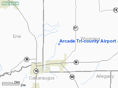
Arcade Tri-county Airport |
Location & QuickFacts
| FAA Information Effective: | 2008-09-25 |
| Airport Identifier: | D23 |
| Airport Status: | Operational |
| Longitude/Latitude: | 078-25-34.0660W/42-34-00.2230N
-78.426129/42.566729 (Estimated) |
| Elevation: | 1745 ft / 531.88 m (Estimated) |
| Land: | 175 acres |
| From nearest city: | 2 nautical miles N of Arcade, NY |
| Location: | Wyoming County, NY |
| Magnetic Variation: | 10W (1985) |
Owner & Manager
| Ownership: | Privately owned |
| Owner: | Larry Snyder |
| Address: | 8234 Hunters Creek Rd
Holland, NY 14080 |
| Phone number: | 716-537-9172 |
| Manager: | Larry Snyder |
| Address: | 8234 Hunters Creek Rd
Holland, NY 14080 |
| Phone number: | 716-537-9172 |
Airport Operations and Facilities
| Airport Use: | Open to public |
| Wind indicator: | Yes |
| Segmented Circle: | No |
| Control Tower: | No |
| Lighting Schedule: | RDO-CTL
ACTVT MIRL RY 09/27 - 123.0. |
| Landing fee charge: | No |
| Sectional chart: | Detroit |
| Region: | AEA - Eastern |
| Boundary ARTCC: | ZOB - Cleveland |
| Tie-in FSS: | BUF - Buffalo |
| FSS on Airport: | No |
| FSS Toll Free: | 1-800-WX-BRIEF |
| NOTAMs Facility: | BUF (NOTAM-d service avaliable) |
Airport Communications
| CTAF: | 123.000 |
| Unicom: | 123.000 |
Airport Services
| Airframe Repair: | NONE |
| Power Plant Repair: | NONE |
Runway Information
Runway 09/27
| Dimension: | 3220 x 60 ft / 981.5 x 18.3 m |
| Surface: | GRVL, Fair Condition |
| Edge Lights: | Medium |
| |
Runway 09 |
Runway 27 |
| Traffic Pattern: | Left | Left |
| Markings: | Basic, | Basic, |
| Obstruction: | 62 ft trees, 114 ft right of centerline | 9 ft brush, 129.0 ft from runway, 11 ft left of centerline, 14:1 slope to clear |
|
Runway 14/32
| Dimension: | 2710 x 80 ft / 826.0 x 24.4 m |
| Surface: | TURF, Fair Condition |
| |
Runway 14 |
Runway 32 |
| Traffic Pattern: | Left | Left |
| Obstruction: | 26 ft trees, 268.0 ft from runway, 97 ft right of centerline, 10:1 slope to clear | 87 ft trees, 0.0 ft from runway, 120 ft left of centerline |
|
Radio Navigation Aids
| ID |
Type |
Name |
Ch |
Freq |
Var |
Dist |
| LYS | NDB | Olean | | 360.00 | 09W | 17.5 nm |
| EL | NDB | Halos | | 269.00 | 09W | 35.6 nm |
| AVN | NDB | Avon | | 344.00 | 09W | 39.4 nm |
| IAG | TACAN | Niagara Falls | 047X | | 10W | 40.4 nm |
| BUF | VOR/DME | Buffalo | 111X | 116.40 | 08W | 23.8 nm |
| GEE | VOR/DME | Geneseo | 019X | 108.20 | 09W | 34.6 nm |
| JHW | VOR/DME | Jamestown | 094X | 114.70 | 07W | 38.3 nm |
| BFD | VOR/DME | Bradford | 113X | 116.60 | 07W | 47.7 nm |
| ELZ | VORTAC | Wellsville | 051X | 111.40 | 09W | 34.4 nm |
| DKK | VORTAC | Dunkirk | 109X | 116.20 | 07W | 37.8 nm |
| ROC | VORTAC | Rochester | 037X | 110.00 | 09W | 47.0 nm |
| BUF | VOT | Buffalo | | 109.00 | | 26.2 nm |
Remarks
- PARACHUTE ACTIVITIES IRREGULAR HOURS.
- ULTRALGT ACFT PROHIBITED.
- ARPT CLSD WINTER MONTHS.
- PRVDD ALL OPNS DAYLGT VFR UNLESS LIGHTING INSTALLED, OPNS CONDUCTED TO MINIMIZE NOISE, ASSURE COORDINATION WITH PVT-USE ARPT TO ASSURE EACH IS FAMILIAR WITH TFC PATTERSN & VISUAL REPORTING POINTS AT EACH FACILITY, & TREES AT APCH RY 07 WOULD REQUIRE DSPLCD THLD FOR SAFE PUBLIC-USE OPNS.
Images and information placed above are from
http://www.airport-data.com/airport/D23/
We thank them for the data!
| General Info
|
| Country |
United States
|
| State |
NEW YORK
|
| FAA ID |
D23
|
| Latitude |
42-34-00.223N
|
| Longitude |
078-25-34.066W
|
| Elevation |
1745 feet
|
| Near City |
ARCADE
|
We don't guarantee the information is fresh and accurate. The data may
be wrong or outdated.
For more up-to-date information please refer to other sources.
|
|


