 |
|
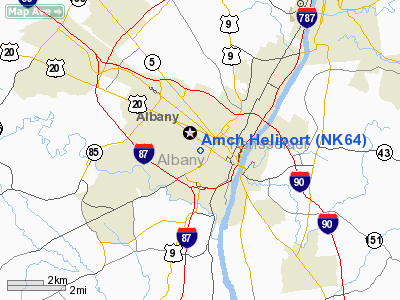
Location & QuickFacts
| FAA Information Effective: | 2008-09-25 |
| Airport Identifier: | NK64 |
| Airport Status: | Operational |
| Longitude/Latitude: | 073-46-29.4360W/42-39-06.2850N
-73.774843/42.651746 (Estimated) |
| Elevation: | 209 ft / 63.70 m (Estimated) |
| Land: | 0 acres |
| From nearest city: | 8 nautical miles N of Albany, NY |
| Location: | Albany County, NY |
| Magnetic Variation: | 14W (1985) |
Owner & Manager
| Ownership: | Privately owned |
| Owner: | Albany Medical Center Hosp |
| Address: | New Scotland Avenue
Albany, NY 12208 |
| Phone number: | 518-445-3595 |
| Manager: | Claude D. Rounds |
| Address: | New Scotland Avenue
Albany, NY 12208 |
| Phone number: | 518-445-3243 |
Airport Operations and Facilities
| Airport Use: | Private |
| Wind indicator: | Yes |
| Segmented Circle: | No |
| Control Tower: | No |
| Landing fee charge: | No |
| Sectional chart: | New York |
| Region: | AEA - Eastern |
| Boundary ARTCC: | ZBW - Boston |
| Tie-in FSS: | BTV - Burlington |
| FSS on Airport: | No |
| FSS Toll Free: | 1-800-WX-BRIEF |
Runway Information
Helipad H1
| Dimension: | 80 x 80 ft / 24.4 x 24.4 m |
| Surface: | ASPH, |
| |
Runway H1 |
Runway |
| Traffic Pattern: | Left | Left |
|
Radio Navigation Aids
| ID |
Type |
Name |
Ch |
Freq |
Var |
Dist |
| PSF | FAN MARKER | Abyss | | | 13W | 27.5 nm |
| GBR | FAN MARKER | Sheffield | | | 13W | 36.4 nm |
| HEU | NDB | Hunter | | 356.00 | 14W | 14.0 nm |
| PFH | NDB | Philmont | | 272.00 | 13W | 24.1 nm |
| DXT | NDB | Dalton | | 370.00 | 15W | 28.9 nm |
| JJH | NDB | Johnstown | | 523.00 | 14W | 32.3 nm |
| GBR | NDB | Great Barrington | | 395.00 | 14W | 32.6 nm |
| VWD | NDB | Mount Snow | | 224.00 | 15W | 43.5 nm |
| CAM | VOR/DME | Cambridge | 097X | 115.00 | 14W | 28.0 nm |
| CTR | VOR/DME | Chester | 098X | 115.10 | 13W | 42.5 nm |
| ALB | VORTAC | Albany | 100X | 115.30 | 13W | 5.9 nm |
| GFL | VORTAC | Glens Falls | 039X | 110.20 | 14W | 42.1 nm |
| ALB | VOT | Albany County | | 108.20 | | 5.8 nm |
Remarks
- PRVDD HELIPORT USED FOR VFR OPERATIONS ONLY AND A 4' FENCE IS ERECTED ON THE SOUTH & EAST SIDES OF THE SITE.
Images and information placed above are from
http://www.airport-data.com/airport/NK64/
We thank them for the data!
| General Info
|
| Country |
United States
|
| State |
NEW YORK
|
| FAA ID |
NK64
|
| Latitude |
42-39-06.285N
|
| Longitude |
073-46-29.436W
|
| Elevation |
209 feet
|
| Near City |
ALBANY
|
We don't guarantee the information is fresh and accurate. The data may
be wrong or outdated.
For more up-to-date information please refer to other sources.
|
|


