|
|
| Albany International Airport |
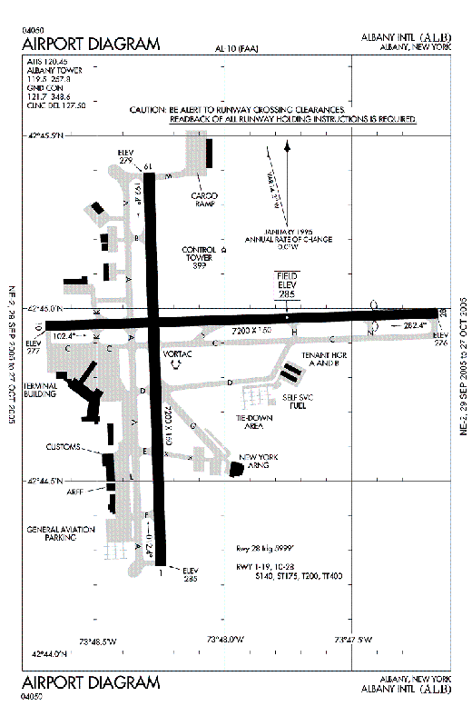 |
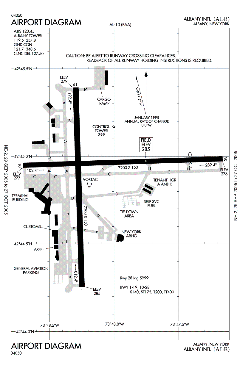
| FAA airport diagram |
| IATA: none – ICAO: KALB – FAA LID: ALB
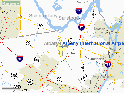
Location of the Albany International Airport
|
| Summary |
| Airport type |
Public |
| Owner |
Albany County Airport Authority |
| Serves |
Albany, New York |
| Location |
Colonie, New York |
| Elevation AMSL |
285 ft / 87 m |
| Coordinates |
42°44′57″N 073°48′07″W / 42.74917°N 73.80194°W / 42.74917; -73.80194 |
| Runways |
| Direction |
Length |
Surface |
| ft |
m |
| 1/19 |
8,500 |
2,591 |
Asphalt |
| 10/28 |
7,200 |
2,195 |
Asphalt |
| Statistics (2009) |
| Aircraft operations |
160,218 |
| Based aircraft |
93 |
| Source: Federal Aviation Administration |
Albany International Airport (IATA: ALB, ICAO: KALB, FAA LID: ALB) is a public use airport located six nautical miles (11 km) northwest of the central business district of Albany, in Albany County, New York, United States. It is owned by the Albany County Airport Authority.
It is an airport of entry serving Albany and located in the town of Colonie. It was built on the site of the Shaker settlement about 6 miles (10 km) north of Albany and stretching north to the hamlet of Verdoy. The airport is the seat of a class C airspace.
Albany International Airport can accept most aircraft. In the past, most airlines operated mainline aircraft to ALB. The biggest aircraft that flew into ALB was Air Force One (Boeing 747), which made two appearances: one in 1994, and the other in 2009. Additionally, the C-5 Galaxy has landed for training, for cargo during Hurricane Katrina, and for the transportation of President Obama's motorcade on September 20 and 21, 2009. An Air Canada Airbus A340-300 (which has seating for 286 passengers) made an unscheduled arrival on December 21, 2007. Many times a week, UPS runs a 757-200 in from their Hartford, CT hub for cargo. FedEx Airlines brings some of the last of the Boeing 727-200 to the airport about 5 times a week for cargo. Today, about half of the planes that depart and land in ALB are regional aircraft. The only airlines to still operate mainline aircraft are Delta Air Lines, Southwest Airlines, United Airlines, and US Airways. The largest passenger aircraft to fly into ALB daily is the Airbus 320 operated by United Airlines with seating for 144 passengers.
The airport previously had pay-as-you-go Wi-Fi access throughout the entire airport provided by WiFiFee, but recently introduced free WiFi service. History
Albany International was the first, and remains the oldest, municipal airport in the United States. In 1908 the airstrip was located on a former polo field on Loudonville Road, three miles (5 km) north of the city in the town of Colonie. In 1909 the airport was moved to Westerlo Island, which is in the city of Albany, but at that time was in the town of Bethlehem. The airport was named after Teddy Roosevelt's son, Quentin, a fighter pilot during World War I. A $10,000 prize was established for sustained flight between Albany and New York City; Glen Curtiss achieved this feat on May 29, 1910. Other early pioneers of aviation that stopped at this early field were Charles Lindbergh, Amelia Earhart, and James Doolittle.
Mayor John Boyd Thacher II once said "a city without the foresight to build an airport for the new traffic may soon be left behind in the race for competition". He therefore decided to build in 1928 a new modern airport on the Shaker site near Albany-Shaker Road in Colonie, not far from the original polo fields used as the first site of the municipal airport. The Shakers not only sold the land used but also loaned the use of tractors and tools.
The early Albany Airport was often closed and threatened with closure which prompted repeated improvements in the late 1930s and 40's. The airport was closed from January 1939 until December 1940 when it reopened to traffic during daylight hours only, and then with no restrictions since January 1942. The airport has not been closed (other than for weather related reasons and emergency landings) since.
The airport up until 1960 had been jointly owned and managed by the city and county of Albany. It was in 1960 that Mayor Erastus Corning 2nd ended the city's stake.
In 1962 a new terminal building was opened. There was a landside building that contained ticket counters, a coffee shop, and baggage claim on the first floor, and a restaurant, offices and viewing area on the second floor. A single-story boarding concourse extended outwards from this building. In 1968 this concourse was widened to allow more concessions and boarding space. The terminal was expanded again in 1979, with the addition of a new two-story building attached diagonally to the northwest. It contained boarding gates for Allegheny Airlines on the second floor, and baggage carousels on the first floor.
The Albany County Airport Authority was created by the county in 1993 with a 40 year lease to operate the airport in 1996. A new terminal was begun on May 16, 1996, officially opening June 1998. It was built around the existing terminal, most of which was demolished upon its completion. Only the 1979 extension remains from the old terminal building.
Service history
At the time of US Airline Deregulation in 1978, most of Albany's service was provided by two "trunk carriers" (American Airlines and Eastern Air Lines) and one "local service carrier" (Allegheny Airlines, which renamed itself USAir in 1979). After Deregulation, many new airlines expanded to Albany. Most did not survive the tumultuous 1980's.
Airlines that served Albany after Deregulation include (but are not limited to):
- Braniff International Airways, which added Albany as part of an unsuccessful large expansion in 1979. Albany was the only Upstate New York market served by this colorful and storied Dallas-based airline, which shut down in 1982.
- Empire Airlines (1976-1985), a regional carrier based in Utica, opened a hub at Syracuse Hancock International Airport after Deregulation and operated flights from Albany and numerous destinations in the Northeast with a fleet of large regional jets and turboprop aircraft.
- Mall Airways, a commuter carrier, ran a hub at Albany in the 1980s with small turboprop aircraft, and operated flights around the Northeast and into Canada.
- Peoplexpress Airlines, a low-cost carrier founded in 1981 with a hub at Newark International Airport. People grew quickly into a major carrier, but some bad decisions led to its downfall and purchase by Continental Airlines in 1986. Continental's Continental Express and Continental Connection affiliates serve Albany today.
- Piedmont Airlines, a pre-deregulation local service carrier based in North Carolina, expanded to the Northeast with a hub at Baltimore-Washington International Airport. They served Albany from this hub. They also bought Empire in 1985 and merged them into itself. In 1987 Piedmont was bought by USAir who wanted to eliminate the unwelcome new competition.
- Republic Airlines (1979-1986), an airline formed from the merger of three pre-Deregulation local service carriers, added service from Albany to their Detroit hub in 1984. They were bought by Northwest Airlines in 1987; Northwest was bought by Delta Air Lines in 2008 and will be merged into them later in 2009.
- United Airlines, which had long served Rochester and Buffalo, added Albany and Syracuse in 1982. United and its affiliates serve Albany today.
During 1986-1987 the airline industry consolidated through a series of mergers, so that after 1989 the US airline industry was dominated by a group of six "legacy carriers:" American, United, Delta, Northwest, USAir, and Continental. All of them served Albany themselves or by their regional affiliates. During the 1990s Albany and other Upstate markets enjoyed little low-fare service, and the legacy carriers mostly kept fares high. Southwest Airlines' entry into Albany in 2000 ushered in a new era of low fare service at the airport.
Recent history
- Albany International Airport is receiving $5.9 million in federal stimulus money to benefit the effort to remove a water tower which is considered an obstruction by the FAA for incoming aircraft on the runway 28 approach.
- American Eagle ended service to ALB on November 1, 2008. Originally ALB had service by American Airlines, but that ended after 9/11.
- Albany International Airport is one of only 4 airports in the world using dual jet bridges (one bridge for the back, one for the front). However, only Southwest Airlines uses them.
- US Airways used to have major operations at Albany, including its own hangar, US Airways Club, MetroJet services to Orlando and Baltimore, and dozens of mainline flights a day. These services were cut down when US Airways went bankrupt in the period after the 9/11 attacks.
- Construction has recently been completed on the 1,300-foot (400 m) runway extension for runway 1/19. The runway now measures 8,500 feet (2,600 m).
- With the January 2006 shutdown of Independence Air, the airport is in further discussions with JetBlue Airways (which serves all other major upstate airports), AirTran (which served Albany for a brief period in the late 1990s) [1], and Frontier Airlines to expand service to the airport.
- In the past ALB had been serviced by Delta Express flying to Orlando and Tampa, MetroJet flying to Orlando and Baltimore. In those airlines' final years of operation, when they flew alongside Southwest Airlines, Albany had up to eight flights to Orlando.
- ALB has become a focus city for Cape Air flying to Watertown, Ogdensburg, and Massena.
 | |
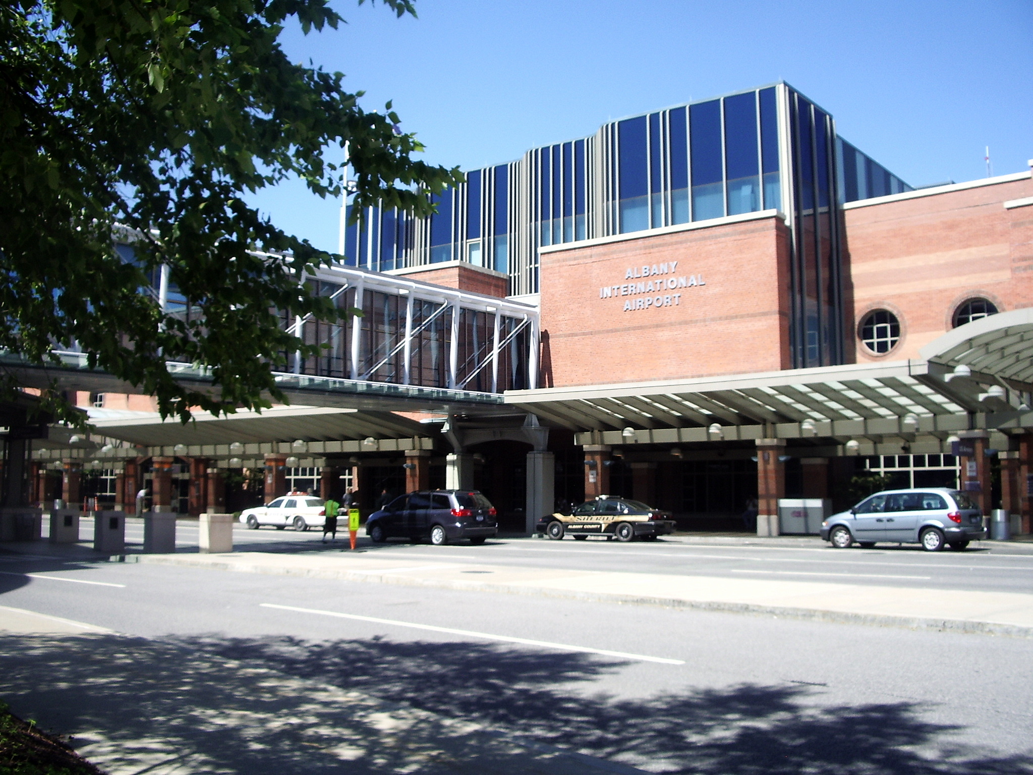
Entrance to Albany International Airport |
CommutAir Hub
In early 2001, CommutAir started to invest in an Albany hub. The hub was to connect smaller cities with bigger cities with Continental Express and mainline. At its peak CommutAir served Allentown, Bangor, Binghamton, Boston, Buffalo, Burlington, Elmira, Portland, Harrisburg, Nantucket, Scranton, La Guardia, Islip, Hartford, White Plains, Manchester, Providence, Syracuse, Rochester, Lake Placid, Montreal, Ottawa, and Plattsburgh. The hub was closed down in late 2005 to shift operations to Cleveland. A few of the markets did do well. The hub was served by Beechcraft 1900's operated by CommutAir for Continental Connection.
The Anticipated Concourse D
There have been discussions between the Town of Colonie and The Albany Airport Board regarding the construction of a new concourse. The concourse will be built to satisfy the needs of a growing US Airways and Southwest, and will also become an international concourse with immigration and customs facilities. Southwest only has two gates for their operations which is not enough. At times, aircraft have to wait until one of the two gates open up or passengers have to deplane on the tarmac via airstairs. The new concourse will also be useful to attract new airlines to ALB. Continental Airlines has also shown interest in a new concourse because, due to them only having one gate, each plane has to wait for the other aircraft occupying the gate to leave. The concourse will have approximately 10 gates. However, there is insufficient space for the new facility on airport property at this time.
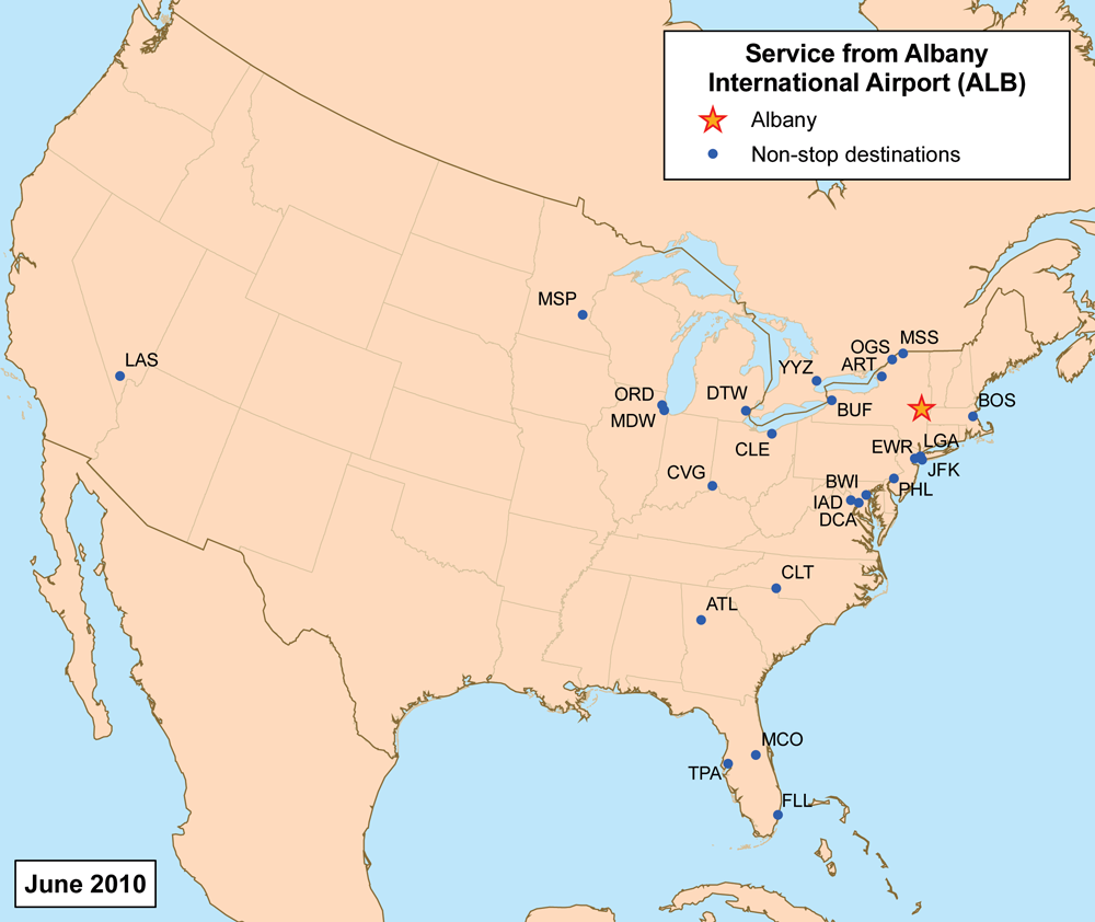
Airlines and destinations
| Airlines |
Destinations |
Concourse |
| Air Canada operated by Air Georgian |
Toronto-Pearson |
C |
| Cape Air |
Ogdensburg, Massena, Watertown |
A |
| Continental Connection operated by Colgan Air |
Newark |
C |
| Continental Connection operated by CommutAir |
Newark |
C |
| Continental Express operated by ExpressJet Airlines |
Cleveland, Newark |
C |
| Delta Air Lines |
Seasonal: Atlanta, Detroit |
B |
| Delta Connection operated by Atlantic Southeast Airlines |
Atlanta, Detroit |
B |
| Delta Connection operated by Chautauqua Airlines |
New York-JFK |
B |
| Delta Connection operated by Comair |
Detroit, New York-JFK |
B |
| Delta Connection operated by Compass Airlines |
Minneapolis/St. Paul |
B |
| Delta Connection operated by Mesaba Airlines |
Detroit
Seasonal: Minneapolis/St. Paul |
B |
| Delta Connection operated by Pinnacle Airlines |
Atlanta, Detroit |
B |
| Southwest Airlines |
Baltimore, Chicago-Midway, Fort Lauderdale, Las Vegas, Orlando, Tampa |
C |
| United Airlines |
Chicago-O'Hare |
A |
| United Express operated by Atlantic Southeast Airlines |
Chicago-O'Hare, Washington-Dulles |
A |
| United Express operated by Expressjet Airlines |
Chicago-O'Hare,Washington-Dulles |
A |
| United Express operated by GoJet Airlines |
Chicago-O'Hare, Washington-Dulles |
A |
| United Express operated by Mesa Airlines |
Chicago-O'Hare, Washington-Dulles |
A |
| US Airways |
Charlotte |
B |
| US Airways Express operated by Air Wisconsin |
Philadelphia, Washington-Reagan |
B |
| US Airways Express operated by Colgan Air |
Boston |
B |
| US Airways Express operated by Piedmont Airlines |
New York-LaGuardia, Philadelphia |
B |
| US Airways Express operated by Republic Airlines |
Charlotte, Philadelphia, Washington-Reagan |
B |
Cargo carriers
- Air Cargo Carriers
- AirNet Systems
- Ameriflight
- FedEx Express
- UPS Airlines
Airline share
| Airline |
Percent of Total Enplanements in 2009 |
| Southwest |
38.8% |
| US Airways |
20.1% |
| United |
14.1% |
| Delta |
9.8% |
| Continental |
8.2% |
| Northwest |
8.1% |
| Cape Air |
0.6% |
| Air Canada |
0.3% |
| American Eagle |
0.0% |
Source: [2]
Incidents and Accidents
On September 16 1953, American Airlines Flight 723 crashed while attempting to land in heavy fog. All 28 people (25 passengers and 3 crew members) were killed in the crash.
On March 3, 1972, Mohawk Airlines Flight 405 crashed while attempting to land at the conclusion of a flight from New York's LaGuardia Airport. 16 passengers and crew were killed, as well as one fatality on the ground.
The above content comes from Wikipedia and is published under free licenses – click here to read more.
Location & QuickFacts
| FAA Information Effective: | 2008-09-25 |
| Airport Identifier: | ALB |
| Airport Status: | Operational |
| Longitude/Latitude: | 073-48-07.1000W/42-44-56.8000N
-73.801972/42.749111 (Estimated) |
| Elevation: | 285 ft / 86.87 m (Surveyed) |
| Land: | 1000 acres |
| From nearest city: | 6 nautical miles NW of Albany, NY |
| Location: | Albany County, NY |
| Magnetic Variation: | 13W (1980) |
Owner & Manager
| Ownership: | Publicly owned |
| Owner: | Albany County Arpt Auth
LEASEE. PROPERTY OWNED BY ALBANY COUNTY, 112 STATE ST., ALBANY, NY 12207; TELEPHONE 518-447-7000. |
| Address: | Arff Bldg Rm 200
Albany, NY 12211 |
| Phone number: | 518-242-2200 |
| Manager: | Joel Russell |
| Address: | 737 Albany Shaker Road
Albany, NY 12211 |
| Phone number: | 518-242-2352 |
Airport Operations and Facilities
| Airport Use: | Open to public |
| Wind indicator: | Yes |
| Segmented Circle: | No |
| Control Tower: | Yes |
| Lighting Schedule: | DUSK-DAWN |
| Beacon Color: | Clear-Green (lighted land airport) |
| Landing fee charge: | Yes |
| Sectional chart: | New York |
| Region: | AEA - Eastern |
| Boundary ARTCC: | ZBW - Boston |
| Tie-in FSS: | BTV - Burlington |
| FSS Toll Free: | 1-800-WX-BRIEF |
| NOTAMs Facility: | ALB (NOTAM-d service avaliable) |
| Certification type/date: | I C S 05/1973 |
| Federal Agreements: | NGHY |
Airport Communications
Airport Services
| Fuel available: | 100LLA |
| Airframe Repair: | MAJOR |
| Power Plant Repair: | MAJOR |
| Bottled Oxygen: | HIGH |
Runway Information
Runway 01/19
| Dimension: | 8500 x 150 ft / 2590.8 x 45.7 m |
| Surface: | ASPH, Good Condition |
| Surface Treatment: | Saw-cut or plastic Grooved |
| Weight Limit: | Single wheel: 140000 lbs.
Dual wheel: 200000 lbs.
Dual tandem wheel: 400000 lbs. |
| Edge Lights: | High |
| |
Runway 01 |
Runway 19 |
| Longitude: | 073-48-15.3198W | 073-48-18.9573W |
| Latitude: | 42-44-13.7922N | 42-45-37.7058N |
| Elevation: | 284.00 ft | 280.00 ft |
| Alignment: | 127 | 127 |
| ILS Type: | ILS/DME
| ILS/DME
|
| Traffic Pattern: | Left | Left |
| Markings: | Precision instrument, Fair Condition | Precision instrument, Fair Condition |
| Crossing Height: | 54.00 ft | 0.00 ft |
| VASI: | 4-light PAPI on right side | |
| Visual Glide Angle: | 3.00° | 0.00° |
| RVR Equipment: | touchdown, rollout | touchdown, rollout |
| Approach lights: | MALSR | MALS |
| Centerline Lights: | Yes | Yes |
| Touchdown Lights: | No | No |
| Obstruction: | , 50:1 slope to clear | 80 ft tree, 2040.0 ft from runway, 75 ft left of centerline, 23:1 slope to clear |
| Decleard distances: | Take off run available 8500.00 ft
Take off distance available 8500.00 ft
Actual stop distance available 8500.00 ft
Landing distance available 8500.00 ft
| Take off run available 8500.00 ft
Take off distance available 8500.00 ft
Actual stop distance available 8500.00 ft
Landing distance available 8500.00 ft
|
|
Runway 10/28
| Dimension: | 7200 x 150 ft / 2194.6 x 45.7 m |
| Surface: | ASPH, Good Condition |
| Surface Treatment: | Saw-cut or plastic Grooved |
| Weight Limit: | Single wheel: 140000 lbs.
Dual wheel: 200000 lbs.
Dual tandem wheel: 400000 lbs. |
| Edge Lights: | Medium |
| |
Runway 10 |
Runway 28 |
| Longitude: | 073-48-43.5284W | 073-47-07.0866W |
| Latitude: | 42-44-56.9415N | 42-44-59.1972N |
| Elevation: | 277.00 ft | 276.00 ft |
| Alignment: | 88 | 127 |
| Traffic Pattern: | Left | Left |
| Markings: | Non-precision instrument, Fair Condition | Non-precision instrument, Fair Condition |
| Crossing Height: | 0.00 ft | 50.00 ft |
| Displaced threshold: | 0.00 ft | 1202.00 ft |
| VASI: | | 4-light PAPI on left side |
| Visual Glide Angle: | 0.00° | 3.35° |
| Runway End Identifier: | Yes | Yes |
| Centerline Lights: | Yes | Yes |
| Obstruction: | 100 ft trees, 1820.0 ft from runway, 350 ft right of centerline, 16:1 slope to clear
+4 FT ELECTRICAL EQUIPMENT FROM RY END 440 FT LEFT. | 249 ft tank, 5074.0 ft from runway, 250 ft left of centerline, 19:1 slope to clear
APCH SLOPE 25:1 TO DSPLCD THLD. |
| Decleard distances: | Take off run available 7200.00 ft
Take off distance available 7200.00 ft
Actual stop distance available 6780.00 ft
Landing distance available 6780.00 ft
| Take off run available 7200.00 ft
Take off distance available 7200.00 ft
Actual stop distance available 7200.00 ft
Landing distance available 6000.00 ft
|
|
Radio Navigation Aids
| ID |
Type |
Name |
Ch |
Freq |
Var |
Dist |
| PSF | FAN MARKER | Abyss | | | 13W | 31.4 nm |
| GBR | FAN MARKER | Sheffield | | | 13W | 42.1 nm |
| HEU | NDB | Hunter | | 356.00 | 14W | 8.5 nm |
| JJH | NDB | Johnstown | | 523.00 | 14W | 27.8 nm |
| PFH | NDB | Philmont | | 272.00 | 13W | 30.0 nm |
| DXT | NDB | Dalton | | 370.00 | 15W | 32.6 nm |
| GBR | NDB | Great Barrington | | 395.00 | 14W | 38.3 nm |
| VWD | NDB | Mount Snow | | 224.00 | 15W | 42.7 nm |
| CAM | VOR/DME | Cambridge | 097X | 115.00 | 14W | 25.0 nm |
| CTR | VOR/DME | Chester | 098X | 115.10 | 13W | 46.7 nm |
| ALB | VORTAC | Albany | 100X | 115.30 | 13W | 0.1 nm |
| GFL | VORTAC | Glens Falls | 039X | 110.20 | 14W | 36.6 nm |
| ALB | VOT | Albany County | | 108.20 | | 1.0 nm |
Remarks
- TWY D EAST OF RY 01/19 IS RESTRD TO ACFT 12500 LBS & LESS.
- BIRDS & DEER ON & INVOF ARPT.
- WEATHER BALLOON LAUNCHES APRXLY 3 MI SOUTH OF ARPT AT 0600 & 1800.
- TWY 'C' W OF TWY 'A' NON MOVEMENT AREA.
- CUSTOMS/IMMIGRATION FIS FACILITY LCTD NORTH END GENERAL AVIATION APRON. ACFT CLEARING CUSTOMS PLEASE UTILIZE PAINTED POSITION MKGS & PROCEED CAUTIOUSLY TO MINIMIZE BLAST IMPACT.
Images and information placed above are from
http://www.airport-data.com/airport/ALB/
We thank them for the data!
| General Info
|
| Country |
United States
|
| State |
NEW YORK
|
| FAA ID |
ALB
|
| Latitude |
42-44-53.230N
|
| Longitude |
073-48-10.723W
|
| Elevation |
285 feet
|
| Near City |
ALBANY
|
We don't guarantee the information is fresh and accurate. The data may
be wrong or outdated.
For more up-to-date information please refer to other sources.
|
|