 |
|
| Akron Airport |
| IATA: none – ICAO: none – FAA LID: 9G3 |
| Summary |
| Airport type |
Public |
| Owner |
Christian Airmen Inc. |
| Serves |
Akron, New York |
| Elevation AMSL |
840 ft / 256 m |
| Coordinates |
43°01′16″N 078°28′57″W / 43.02111°N 78.4825°W / 43.02111; -78.4825 |
| Runways |
| Direction |
Length |
Surface |
| ft |
m |
| 7/25 |
3,270 |
997 |
Asphalt |
| 11/29 |
1,955 |
596 |
Turf |
| Statistics (2009) |
| Aircraft operations |
50,900 |
| Based aircraft |
54 |
| Source: Federal Aviation Administration |
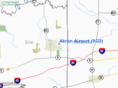
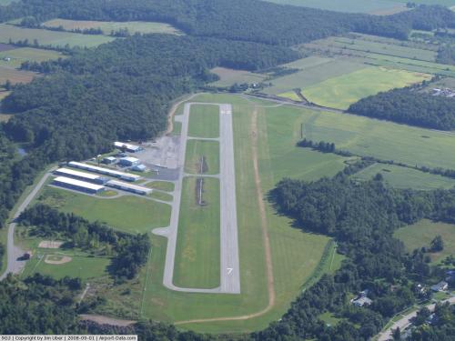
Akron Airport (FAA LID: 9G3) is a privately-owned, public-use airport located one nautical miles (1.852 km) east of the central business district of Akron, a village in Erie County, New York, United States. Facilities and aircraft
Akron Airport covers an area of 137 acres (55 ha) which contains two runways. Runway 7/25 has an asphalt pavement measuring 3,270 by 75 feet (997 by 23 m). Runway 11/29 has a turf surface measuring 1,955 by 50 feet (596 by 15 m).
For the 12-month period ending September 11, 2009, the airport had 50,900 aircraft operations, an average of 139 per day: 98% general aviation and 2% air taxi. At that time there were 54 aircraft based at this airport: 98% single-engine and 2% multi-engine.
Nearby airports
0G0 - North Buffalo Suburban Airport (11 nm NW)
KBUF - Buffalo Niagara International Airport (12 nm SW)
9G6 - Pine Hill Airport (13 nm NE)
KGVQ - Genesee County Airport (14 nm E)
9G0 - Buffalo Airfield (14 nm SW)
Source: AirNav
The above content comes from Wikipedia and is published under free licenses – click here to read more.
 |
(Click on the photo to enlarge) |
Location & QuickFacts
| FAA Information Effective: | 2008-09-25 |
| Airport Identifier: | 9G3 |
| Airport Status: | Operational |
| Longitude/Latitude: | 078-28-57.1200W/43-01-16.1000N
-78.482533/43.021139 (Estimated) |
| Elevation: | 840 ft / 256.03 m (Estimated) |
| Land: | 137 acres |
| From nearest city: | 1 nautical miles E of Akron, NY |
| Location: | Erie County, NY |
| Magnetic Variation: | 11W (1990) |
Owner & Manager
| Ownership: | Privately owned |
| Owner: | Christian Airmen Inc. |
| Address: | Po Box 126
Akron, NY 14001 |
| Phone number: | 716-542-4607 |
| Manager: | John Jesson |
| Address: | Box 126, John St.
Akron, NY 14001 |
| Phone number: | 716-542-4607 |
Airport Operations and Facilities
| Airport Use: | Open to public |
| Wind indicator: | Yes |
| Segmented Circle: | No |
| Control Tower: | No |
| Lighting Schedule: | RDO-CTL
ACTVT MIRL RY 07/25, PAPI RYS 07 & 25, & REIL RY 25 - CTAF. |
| Beacon Color: | Clear-Green (lighted land airport) |
| Landing fee charge: | No |
| Sectional chart: | Detroit |
| Region: | AEA - Eastern |
| Traffic Pattern Alt: | 1000 ft |
| Boundary ARTCC: | ZOB - Cleveland |
| Tie-in FSS: | BUF - Buffalo |
| FSS on Airport: | No |
| FSS Toll Free: | 1-800-WX-BRIEF |
| NOTAMs Facility: | BUF (NOTAM-d service avaliable) |
| Federal Agreements: | N |
Airport Communications
| CTAF: | 122.725 |
| Unicom: | 122.725 |
Airport Services
| Fuel available: | 100LL |
| Airframe Repair: | MAJOR |
| Power Plant Repair: | MAJOR |
| Bottled Oxygen: | NONE |
| Bulk Oxygen: | NONE |
Runway Information
Runway 07/25
| Dimension: | 3270 x 75 ft / 996.7 x 22.9 m
RY 11/29 CLSD INDEFLY. |
| Surface: | ASPH, Good Condition |
| Weight Limit: | Single wheel: 8000 lbs. |
| Edge Lights: | Medium |
| |
Runway 07 |
Runway 25 |
| Longitude: | 078-29-16.4600W | 078-28-38.4800W |
| Latitude: | 43-01-07.7800N | 43-01-24.1100N |
| Elevation: | 830.00 ft | 840.00 ft |
| Alignment: | 60 | 127 |
| Traffic Pattern: | Left | Left |
| Markings: | Non-precision instrument, Good Condition | Non-precision instrument, Good Condition |
| Crossing Height: | 56.00 ft | 56.00 ft |
| VASI: | 2-light PAPI on left side | 2-light PAPI on right side |
| Visual Glide Angle: | 4.00° | 4.00° |
| Runway End Identifier: | No | Yes |
| Centerline Lights: | No | No |
| Touchdown Lights: | No | No |
| Obstruction: | 8 ft trees, 200.0 ft from runway
+8 FT FENCE AT 195 FT OUT, 195 FT RT. | 15 ft road, 200.0 ft from runway, 250 ft left of centerline
RY 25 +8 FT FENCE 199 FT OUT AND 250 FT LEFT. |
|
Runway 11/29
| Dimension: | 1955 x 50 ft / 595.9 x 15.2 m
RY 11/29 CLSD INDEFLY. |
| Surface: | TURF, Good Condition |
| |
Runway 11 |
Runway 29 |
| Longitude: | 078-29-12.0840W | 078-28-47.1740W |
| Latitude: | 43-01-17.2120N | 43-01-10.9840N |
| Alignment: | 109 | 127 |
| Traffic Pattern: | Left | Left |
| Obstruction: | 25 ft trees | 50 ft trees, 0.0 ft from runway, 30 ft right of centerline |
|
Radio Navigation Aids
| ID |
Type |
Name |
Ch |
Freq |
Var |
Dist |
| AVN | NDB | Avon | | 344.00 | 09W | 31.4 nm |
| SN | NDB | St Catherines | | 408.00 | 01E | 34.7 nm |
| LYS | NDB | Olean | | 360.00 | 09W | 44.8 nm |
| IAG | TACAN | Niagara Falls | 047X | | 10W | 21.7 nm |
| BUF | VOR/DME | Buffalo | 111X | 116.40 | 08W | 9.1 nm |
| GEE | VOR/DME | Geneseo | 019X | 108.20 | 09W | 34.9 nm |
| ROC | VORTAC | Rochester | 037X | 110.00 | 09W | 36.0 nm |
| DKK | VORTAC | Dunkirk | 109X | 116.20 | 07W | 47.3 nm |
| BUF | VOT | Buffalo | | 109.00 | | 12.1 nm |
Remarks
- RWY 11/29 IS CLOSED INDEFINITELY.
- PARALLEL TWY LIGHTED AND 35 FT WIDE.
- DEER AND TURKEY IN VINCINITY OF A/P.
- RWY 07: +40' TREES 172' RT., 263' FRM RWY; +49' TREES 200-230' LT., 208-332' FROM RWY; +34' TREES PENTRATE TRANSITON SURFACE ON RIGHT SIDE OF RWY (310' FRM CTLN, 0-310' DOWN RWY)
- RWY 25: +43' TREES, 135' LT., 454' FRM RWY; +15' ACCESS RD. 300' FRM RWY, OB
Images and information placed above are from
http://www.airport-data.com/airport/9G3/
We thank them for the data!
| General Info
|
| Country |
United States
|
| State |
NEW YORK
|
| FAA ID |
9G3
|
| Latitude |
43-01-16.100N
|
| Longitude |
078-28-57.120W
|
| Elevation |
840 feet
|
| Near City |
AKRON
|
We don't guarantee the information is fresh and accurate. The data may
be wrong or outdated.
For more up-to-date information please refer to other sources.
|
|


