 |
|
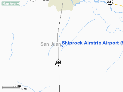
Shiprock Airstrip Airport |
| Shiprock Airstrip |
| IATA: none – ICAO: none – FAA LID: 5V5 |
| Summary |
| Airport type |
Public |
| Operator |
The Navajo Nation |
| Location |
Shiprock, New Mexico |
| Elevation AMSL |
5,270 ft / 1,606 m |
| Coordinates |
36°41′52″N 108°42′04″W / 36.69778°N 108.70111°W / 36.69778; -108.70111Coordinates: 36°41′52″N 108°42′04″W / 36.69778°N 108.70111°W / 36.69778; -108.70111 |
| Runways |
| Direction |
Length |
Surface |
| ft |
m |
| 2/20 |
4,840 |
1,475 |
Asphalt |
Shiprock Airstrip (FAA LID: 5V5), also referred to as Shiprock Airport, is a public airport located five miles (8 km) south of the central business district of Shiprock, in San Juan County, New Mexico, United States.
This is one of six airports owned by the Navajo Nation; the others being Crownpoint Airport (0E8) in New Mexico, plus Chinle Airport (E91), Kayenta Airport (0V7), Tuba City Airport (T03) and Window Rock Airport (RQE) in Arizona.
Facilities
Shiprock Airstrip covers an area of 104 acres (42 ha) and has one runway:
- Runway 2/20: 4,840 x 75 ft (1,475 x 23 m), Surface: Asphalt
The above content comes from Wikipedia and is published under free licenses – click here to read more.
Location & QuickFacts
| FAA Information Effective: | 2008-09-25 |
| Airport Identifier: | 5V5 |
| Airport Status: | Operational |
| Longitude/Latitude: | 108-42-04.3150W/36-41-51.9990N
-108.701199/36.697778 (Estimated) |
| Elevation: | 5270 ft / 1606.30 m (Estimated) |
| Land: | 104 acres |
| From nearest city: | 5 nautical miles S of Shiprock, NM |
| Location: | San Juan County, NM |
| Magnetic Variation: | 12E (1985) |
Owner & Manager
| Ownership: | Publicly owned |
| Owner: | Navajo Tribe |
| Address: | Dept. Of Transportation, Po Box 4620
Window Rock, AZ 86515 |
| Phone number: | 928-871-6498 |
| Manager: | Smauel Johns |
| Address: | Po Box 4620
Window Rock, AZ 86515 |
| Phone number: | 928-810-8527 |
Airport Operations and Facilities
| Airport Use: | Open to public |
| Wind indicator: | Yes |
| Segmented Circle: | Yes |
| Control Tower: | No |
| Landing fee charge: | No |
| Sectional chart: | Denver |
| Region: | ASW - Southwest |
| Boundary ARTCC: | ZDV - Denver |
| Tie-in FSS: | ABQ - Albuquerque |
| FSS on Airport: | No |
| FSS Toll Free: | 1-800-WX-BRIEF |
| NOTAMs Facility: | ABQ (NOTAM-d service avaliable) |
| Federal Agreements: | N |
Airport Communications
Airport Services
| Airframe Repair: | NONE |
| Power Plant Repair: | NONE |
| Bottled Oxygen: | NONE |
| Bulk Oxygen: | NONE |
Runway Information
Runway 02/20
| Dimension: | 4840 x 75 ft / 1475.2 x 22.9 m |
| Surface: | ASPH, Poor Condition
RY HAS BROKEN GLASS & DEBRIS INVOF RY. |
| Weight Limit: | Single wheel: 11000 lbs. |
| |
Runway 02 |
Runway 20 |
| Traffic Pattern: | Left | Left |
| Markings: | Basic, Poor Condition
RY 02/20 MARKINGS FADED. | Basic, Poor Condition |
| Obstruction: | 30 ft pline, 1225.0 ft from runway, 34:1 slope to clear
PLINE 250' LEFT AT CONTROLLING POINT RWY 02. | , 50:1 slope to clear |
|
Radio Navigation Aids
| ID |
Type |
Name |
Ch |
Freq |
Var |
Dist |
| CEZ | VOR/DME | Cortez | 021X | 108.40 | 14E | 42.1 nm |
| RSK | VORTAC | Rattlesnake | 100X | 115.30 | 14E | 29.2 nm |
Remarks
- SHALLOW DRAINAGE DITCH ENTIRE LENGTH NW SIDE OF RY.
- TWY DOES NOT CONNECT TO RY 20 NORTH END.
- RAMP HAS BROKEN GLASS AND DEBRIS.
- COMBINATION FOR AIRPORT ACCESS IS 5270.
Images and information placed above are from
http://www.airport-data.com/airport/5V5/
We thank them for the data!
| General Info
|
| Country |
United States
|
| State |
NEW MEXICO
|
| FAA ID |
5V5
|
| Latitude |
36-41-51.999N
|
| Longitude |
108-42-04.315W
|
| Elevation |
5270 feet
|
| Near City |
SHIPROCK
|
We don't guarantee the information is fresh and accurate. The data may
be wrong or outdated.
For more up-to-date information please refer to other sources.
|
|


