|
|
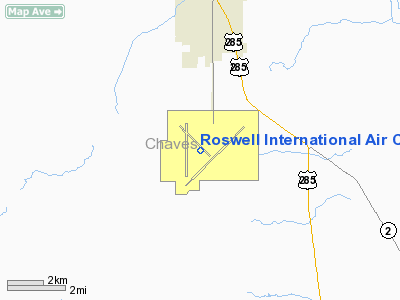
Roswell Intl Air Center Airport |
| Roswell International Air Center |
 |
| IATA: ROW – ICAO: KROW – FAA LID: ROW |
| Summary |
| Airport type |
Public |
| Owner |
City of Roswell |
| Serves |
Roswell, New Mexico |
| Elevation AMSL |
3,671 ft / 1,119 m |
| Coordinates |
33°18′06″N 104°31′50″W / 33.30167°N 104.53056°W / 33.30167; -104.53056 |
| Runways |
| Direction |
Length |
Surface |
| ft |
m |
| 3/21 |
13,001 |
3,963 |
Asphalt/concrete |
| 12/30 |
7,425 |
2,263 |
Asphalt/concrete |
| 17/35 |
10,000 |
3,050 |
Asphalt |
| Statistics (2007) |
| Aircraft operations |
43,990 |
| Based aircraft |
46 |
| Source: Federal Aviation Administration |
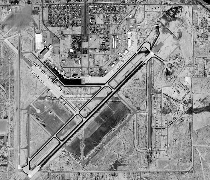
Roswell International Air Center (RIAC) (IATA: ROW, ICAO: KROW, FAA LID: ROW), also known as Roswell Industrial Air Center, is a city-owned public-use airport located three miles (5 km) south of the central business district of Roswell, a city in Chaves County, New Mexico, United States. History
From 1941 to 1967, the facility was known as Roswell Army Airfield during World War II, and Walker Air Force Base during the Cold War. At the time of its closure, it was the largest base of the United States Air Force Strategic Air Command. Roswell International Air Center was developed after the closure of Walker Air Force Base on 30 June 1967.
Walker AFB was named after General Kenneth Newton Walker, a native of Los Cerrillos, New Mexico. He was killed during a bombing mission over Rabaul, New Britain, Papua, New Guinea. on January 5, 1943. Though intercepted by enemy fighters, his group scored direct hits on nine Japanese ships. General Walker was last seen leaving the target area with one engine on fire and several fighters on his tail. For his actions, General Walker was awarded the Medal of Honor posthumously by President Franklin D. Roosevelt in 1943.
The base was renamed in his honor on January 13, 1948. Walker Hall, at Maxwell Air Force Base, Alabama, home of the College of Aerospace Doctrine Research and Education, is also named after the general.
In 1966, the Air Force announced that Walker AFB would be closed. This was during a round of base closings and consolidations as the Defense Department struggled to pay the expenses of the Vietnam War within the budgetary limits set by Congress.
It is also known for the Roswell UFO incident, an event that supposedly happened on 4 July 1947. It is alleged that a "flying disk" crashed during a severe thunderstorm near RIAC at Corona, New Mexico.
The site was used for several years to launch stratospheric balloons for Air Force projects.
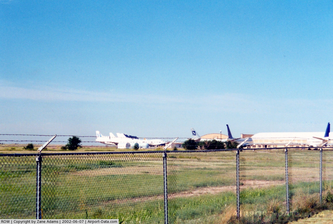
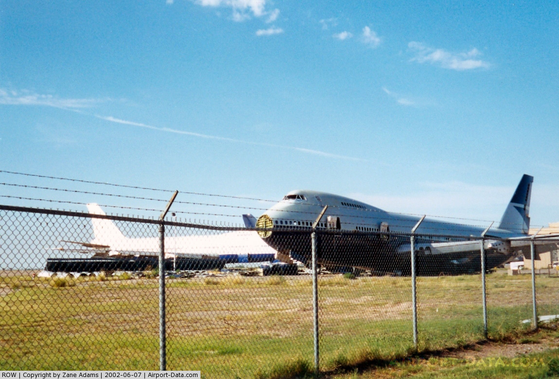
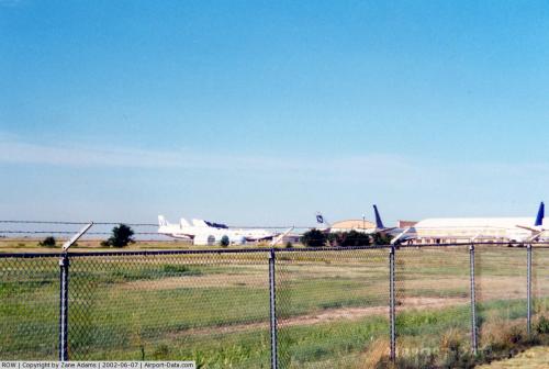
The site is the storage facility for many of American Airlines' retired Airbus A-300 aircraft.
Facilities and aircraft
Roswell International Air Center Airport covers an area of 5,029 acres (2,035 ha), with three paved runways:
- Runway 3/21: 13,001 x 150 ft. (3,963 x 46 m), Surface: asphalt/concrete
- Runway 12/30: 7,425 x 200 ft. (2,263 x 61 m), Surface: asphalt/concrete
- Runway 17/35: 9,999 x 100 ft. (3,048 x 30 m), Surface: asphalt
For the 12-month period ending October 31, 2007, the airport had 43,990 aircraft operations, an average of 120 per day: 51% general aviation, 31% military, 18% air taxi and <1% scheduled commercial. At that time there were 46 aircraft based at this airport: 76% single-engine, 17% multi-engine, 4% jet and 2% helicopter.
Airline and destinations
| Airlines |
Destinations |
| American Eagle |
Dallas/Fort Worth |
Other uses
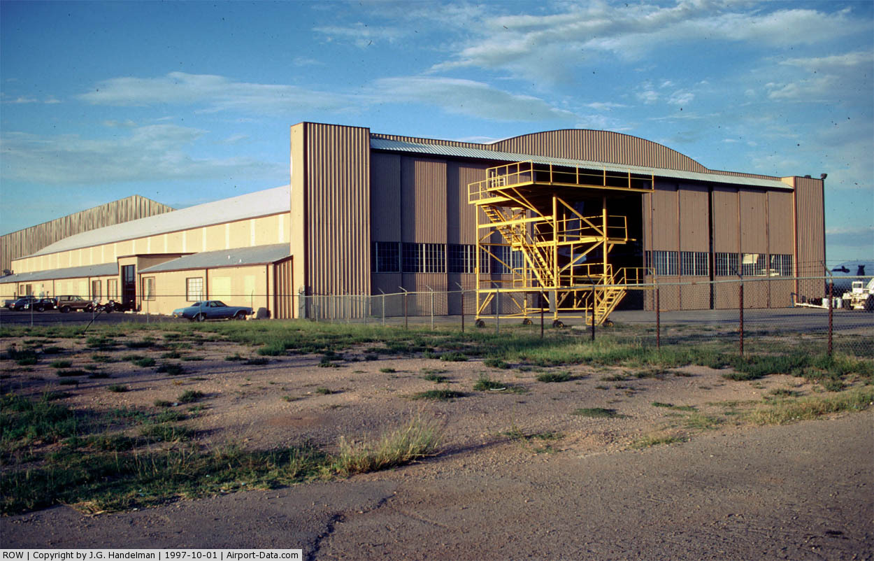
The RIAC is home to a plastic manufacturer; Novabus Inc. has a bus factory there; a candy manufacturer and the Roswell Municipal Airport. Eastern New Mexico University has a campus there, and aircraft repair and refurbishing companies have airliners stored onsite.
RIAC is the home of the New Mexico Rehabilitation Center.
The Boeing Company uses RIAC for braking performance testing of its aircraft, most recent was the testing of the BF Goodrich carbon brakes on the 737-900ER model. Also testing on brakes was performed on the new Boeing 787 Dreamliner.
A New Mexico National Guard unit uses some of the buildings of the facility.
The above content comes from Wikipedia and is published under free licenses – click here to read more.
 |
(Click on the photo to enlarge) |
 |
(Click on the photo to enlarge) |
 |
(Click on the photo to enlarge) |
Location & QuickFacts
| FAA Information Effective: | 2008-09-25 |
| Airport Identifier: | ROW |
| Airport Status: | Operational |
| Longitude/Latitude: | 104-31-50.0000W/33-18-05.6000N
-104.530556/33.301556 (Estimated) |
| Elevation: | 3671 ft / 1118.92 m (Surveyed) |
| Land: | 5029 acres |
| From nearest city: | 3 nautical miles S of Roswell, NM |
| Location: | Chaves County, NM |
| Magnetic Variation: | 10E (1995) |
Owner & Manager
| Ownership: | Publicly owned |
| Owner: | City Of Roswell |
| Address: | 425 N Richardson
Roswell, NM 88201 |
| Phone number: | 575-624-6700 |
| Manager: | Dennis Ybarra |
| Address: | 1 Jerry Smith Circle
Roswell, NM 88203 |
| Phone number: | 575-347-5703 |
Airport Operations and Facilities
| Airport Use: | Open to public |
| Wind indicator: | Yes |
| Segmented Circle: | Yes |
| Control Tower: | Yes |
| Lighting Schedule: | DUSK-DAWN
ACTVT MIRL RY 17/35 & MALSR RY 21 - CTAF. |
| Beacon Color: | Clear-Green (lighted land airport)
ROTG BCN OTS INDEFLY. |
| Landing fee charge: | No |
| Sectional chart: | Albuquerque |
| Region: | ASW - Southwest |
| Boundary ARTCC: | ZAB - Albuquerque |
| Tie-in FSS: | ABQ - Albuquerque |
| FSS on Airport: | No |
| FSS Toll Free: | 1-800-WX-BRIEF |
| NOTAMs Facility: | ROW (NOTAM-d service avaliable) |
| Certification type/date: | I A S 07/1973
CLSD TO ACR OPNS WITH MORE THAN 30 PSGR SEATS EXCP PPR CALL AMGR 575-347-5703 OR 575-626-1827 2 HRS NOTICE REQUIRED. ARFF INDEX B AVAILABLE. |
| Federal Agreements: | NGPY |
Airport Communications
| CTAF: | 118.500 |
| Unicom: | 122.950 |
Airport Services
| Fuel available: | 100LLA A1+
FOR FUEL AFT HRS CALL 575-347-2054. |
| Airframe Repair: | MINOR |
| Power Plant Repair: | MINOR |
| Bulk Oxygen: | LOW |
Runway Information
Runway 03/21
| Dimension: | 13001 x 150 ft / 3962.7 x 45.7 m |
| Surface: | ASPH-CONC, Fair Condition
CENTER 100 FT CONC/100 FT ASPH EITHER SIDE.
PAVEMENT SPALLING, VEGETATION IN CRACKS & LONGITUDINAL CRACKING. |
| Weight Limit: | Single wheel: 100000 lbs.
Dual wheel: 200000 lbs.
Dual tandem wheel: 400000 lbs. |
| Edge Lights: | Non-standard lighting system
MIRL AVBL ON MED INTST ONLY WHEN ATCT CLSD. NSTD MIRL; MIRL LCTD 75 FT FM RY EDGES. |
| |
Runway 03 |
Runway 21 |
| Longitude: | 104-32-12.8503W | 104-30-24.3222W |
| Latitude: | 33-17-09.9357N | 33-18-40.6635N |
| Elevation: | 3667.00 ft | 3624.00 ft |
| Alignment: | 45 | 127 |
| ILS Type: | | ILS/DME
|
| Traffic Pattern: | Right | Left |
| Markings: | Non-precision instrument, Fair Condition | Precision instrument, Fair Condition |
| Crossing Height: | 50.00 ft | 0.00 ft |
| VASI: | 6-box on left side | |
| Visual Glide Angle: | 3.00° | 0.00° |
| Approach lights: | | MALSR |
| Decleard distances: | Take off run available 13001.00 ft
Take off distance available 13001.00 ft
Actual stop distance available 13001.00 ft
Landing distance available 13001.00 ft
| Take off run available 13001.00 ft
Take off distance available 13001.00 ft
Actual stop distance available 13001.00 ft
Landing distance available 13001.00 ft
|
|
Runway 12/30
| Dimension: | 7425 x 200 ft / 2263.1 x 61.0 m |
| Surface: | ASPH-CONC, Poor Condition
CENTER 100 FT CONC/100 FT ASPH EITHER SIDE.
PAVEMENT SPALLING, VEGETATION IN CRACKS & LONGITUDINAL CRACKING. |
| Weight Limit: | Single wheel: 40000 lbs.
Dual wheel: 60000 lbs.
Dual tandem wheel: 120000 lbs. |
| |
Runway 12 |
Runway 30 |
| Longitude: | 104-32-33.8441W | 104-31-32.1219W |
| Latitude: | 33-18-50.3457N | 33-17-58.2991N |
| Elevation: | 3666.00 ft | 3650.00 ft |
| Alignment: | 127 | 127 |
| Traffic Pattern: | Right | Left |
| Markings: | Basic, Fair Condition | Basic, Fair Condition |
| Decleard distances: | Take off run available 7425.00 ft
Take off distance available 7425.00 ft
Actual stop distance available 7425.00 ft
Landing distance available 7425.00 ft
| Take off run available 7425.00 ft
Take off distance available 7425.00 ft
Actual stop distance available 7425.00 ft
Landing distance available 7425.00 ft
|
|
Runway 17/35
| Dimension: | 9999 x 100 ft / 3047.7 x 30.5 m |
| Surface: | ASPH, Good Condition
CENTER 100 FT CONC/100 FT ASPH EITHER SIDE.
PAVEMENT SPALLING, VEGETATION IN CRACKS & LONGITUDINAL CRACKING. |
| Surface Treatment: | Saw-cut or plastic Grooved |
| Weight Limit: | Single wheel: 77000 lbs.
Dual wheel: 104000 lbs.
Dual tandem wheel: 165000 lbs. |
| Edge Lights: | Medium
MIRL AVBL ON MED INTST ONLY WHEN ATCT CLSD. NSTD MIRL; MIRL LCTD 75 FT FM RY EDGES. |
| |
Runway 17 |
Runway 35 |
| Longitude: | 104-32-21.1331W | 104-32-21.3799W |
| Latitude: | 33-18-54.4841N | 33-17-15.5805N |
| Elevation: | 3663.00 ft | 3671.00 ft |
| Alignment: | 127 | 0 |
| Traffic Pattern: | Right | Left |
| Markings: | Non-precision instrument, Good Condition | Non-precision instrument, Good Condition |
| Crossing Height: | 50.00 ft | 50.00 ft |
| VASI: | 4-box on left side | 6-box on left side |
| Visual Glide Angle: | 3.00° | 3.00° |
| Decleard distances: | Take off run available 9999.00 ft
Take off distance available 9999.00 ft
Actual stop distance available 9999.00 ft
Landing distance available 9999.00 ft
| Take off run available 9999.00 ft
Take off distance available 9999.00 ft
Actual stop distance available 9999.00 ft
Landing distance available 9999.00 ft
|
|
Radio Navigation Aids
| ID |
Type |
Name |
Ch |
Freq |
Var |
Dist |
| RO | NDB | Topan | | 305.00 | 10E | 5.9 nm |
| ATS | NDB | Artesia | | 414.00 | 09E | 27.2 nm |
| CEP | NDB | Capitan | | 278.00 | 10E | 45.3 nm |
| CME | VORTAC | Chisum | 108X | 116.10 | 12E | 5.0 nm |
Remarks
- TO EXIT RAMP/FBO AREA AFT HRS USE LGTD PEDESTRIAN GATE WEST SIDE OF TERMINAL. TO ENTER GATE CALL 575-626-1827.
- ASPH RAMP CLSD TO LARGE SKID MOUNTED HELICOPTERS. HELICOPTER PARKING ON GEN AVN RAMP AT WEST END OF TERM BLDG.
- BE ALERT FOR BIRDS ON & INVOF ARPT.
- TWY S NON-MOVEMENT AREA.
- LONG-TERM LARGE ACFT STORAGE AVBL.
- TWY C NON-MOVEMENT AREA.
Images and information placed above are from
http://www.airport-data.com/airport/ROW/
We thank them for the data!
| General Info
|
| Country |
United States
|
| State |
NEW MEXICO
|
| FAA ID |
ROW
|
| Latitude |
33-18-05.600N
|
| Longitude |
104-31-50.000W
|
| Elevation |
3671 feet
|
| Near City |
ROSWELL
|
We don't guarantee the information is fresh and accurate. The data may
be wrong or outdated.
For more up-to-date information please refer to other sources.
|
|