 |
|
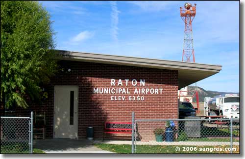
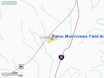
Raton Muni/crews Field Airport |
| Raton Municipal Airport/Crews Field |
 |
| IATA: RTN – ICAO: KRTN |
| Summary |
| Airport type |
Public |
| Operator |
City of Raton |
| Serves |
Colfax County, New Mexico |
| Location |
Raton, New Mexico |
| Elevation AMSL |
6,352 ft / 1,936 m |
| Coordinates |
36°44′30.85″N 104°30′11.05″W / 36.7419028°N 104.5030694°W / 36.7419028; -104.5030694Coordinates: 36°44′30.85″N 104°30′11.05″W / 36.7419028°N 104.5030694°W / 36.7419028; -104.5030694 |
| Runways |
| Direction |
Length |
Surface |
| ft |
m |
| 2/20 |
6,328 |
1,928 |
Asphalt |
| 7/25 |
4,404 |
1,342 |
Asphalt |
Raton Municipal Airport/Crews Field (IATA: RTN, ICAO: KRTN) is a general aviation airport located 10 miles (16 km) southwest of Raton, New Mexico, USA.
Facilities
Raton Municipal Airport/Crews Field covers 1,208 acres (489 ha) and has two runways:
- Runway 2/20: 6,328 x 75 ft (23 m). Surface: Asphalt
- Runway 7/25: 4,404 x 75 ft (23 m). Surface: Asphalt
The above content comes from Wikipedia and is published under free licenses – click here to read more.
Location & QuickFacts
| FAA Information Effective: | 2008-09-25 |
| Airport Identifier: | RTN |
| Airport Status: | Operational |
| Longitude/Latitude: | 104-30-07.8600W/36-44-29.5000N
-104.502183/36.741528 (Estimated) |
| Elevation: | 6352 ft / 1936.09 m (Surveyed) |
| Land: | 1280 acres |
| From nearest city: | 10 nautical miles SW of Raton, NM |
| Location: | Colfax County, NM |
| Magnetic Variation: | 10E (2000) |
Owner & Manager
| Ownership: | Publicly owned |
| Owner: | City Of Raton |
| Address: | Box 19
Raton, NM 87740 |
| Phone number: | 505-445-9551 |
| Manager: | Keith Mangelsdorf
PEGASUS AVIATION FBO. |
| Address: | Hcr 62 Box 19
Raton, NM 87740 |
| Phone number: | 505-445-3076
ALTERNATE PHONE: 505-445-8072. |
Airport Operations and Facilities
| Airport Use: | Open to public |
| Wind indicator: | Yes |
| Segmented Circle: | Yes |
| Control Tower: | No |
| Lighting Schedule: | DUSK-DAWN
MIRL RYS 02/20 & 07/25 PRESET LOW INTST DUSK-2300; TO INCR INTST ACTVT - CTAF. AFT 2300 ACTVT - CTAF. |
| Beacon Color: | Clear-Green (lighted land airport) |
| Landing fee charge: | No |
| Sectional chart: | Denver |
| Region: | ASW - Southwest |
| Boundary ARTCC: | ZAB - Albuquerque |
| Tie-in FSS: | ABQ - Albuquerque |
| FSS on Airport: | No |
| FSS Toll Free: | 1-800-WX-BRIEF |
| NOTAMs Facility: | RTN (NOTAM-d service avaliable) |
| Federal Agreements: | NGY |
Airport Communications
| CTAF: | 122.800 |
| Unicom: | 122.800 |
Airport Services
| Fuel available: | 100LLA1+ |
| Airframe Repair: | MINOR |
| Power Plant Repair: | MINOR |
| Bottled Oxygen: | NONE |
| Bulk Oxygen: | NONE |
Runway Information
Runway 02/20
| Dimension: | 6328 x 75 ft / 1928.8 x 22.9 m |
| Surface: | ASPH, Good Condition |
| Surface Treatment: | Porous Friction Course |
| Weight Limit: | Single wheel: 18000 lbs. |
| Edge Lights: | Medium |
| |
Runway 02 |
Runway 20 |
| Longitude: | 104-30-40.5300W | 104-29-56.8560W |
| Latitude: | 36-44-02.9990N | 36-44-54.7390N |
| Elevation: | 6332.00 ft | 6352.00 ft |
| Alignment: | 34 | 127 |
| Traffic Pattern: | Left | Left |
| Markings: | Non-precision instrument, Good Condition | Basic, Good Condition |
| Crossing Height: | 25.00 ft | 0.00 ft |
| VASI: | pulsating/steady burning on left side | |
| Visual Glide Angle: | 3.00° | 0.00° |
|
Runway 07/25
| Dimension: | 4404 x 75 ft / 1342.3 x 22.9 m |
| Surface: | ASPH, Good Condition |
| Surface Treatment: | Porous Friction Course |
| Weight Limit: | Single wheel: 12000 lbs. |
| Edge Lights: | Medium |
| |
Runway 07 |
Runway 25 |
| Longitude: | 104-30-18.8190W | 104-29-25.9880W |
| Latitude: | 36-44-25.6520N | 36-44-34.9890N |
| Elevation: | 6342.00 ft | 6310.00 ft |
| Alignment: | 78 | 127 |
| Traffic Pattern: | Left | Left |
| Markings: | Basic, Good Condition | Non-precision instrument, Good Condition |
|
Radio Navigation Aids
| ID |
Type |
Name |
Ch |
Freq |
Var |
Dist |
| MXR | NDB | Maxwell | | 284.00 | 10E | 3.1 nm |
| TAD | NDB | Trinidad | | 329.00 | 10E | 34.9 nm |
| CIM | VORTAC | Cimarron | 111X | 116.40 | 13E | 23.3 nm |
Remarks
- RY 02/20 STOPWAY UNLGTD 240 FT SOUTH END.
- TWYS 40 FT WIDE BORDERED BY REFLECTIVE MARKERS.
- ELK ON AND IN VICINITY OF AIRPORT.
Images and information placed above are from
http://www.airport-data.com/airport/RTN/
We thank them for the data!
| General Info
|
| Country |
United States
|
| State |
NEW MEXICO
|
| FAA ID |
RTN
|
| Latitude |
36-44-29.500N
|
| Longitude |
104-30-07.860W
|
| Elevation |
6352 feet
|
| Near City |
RATON
|
We don't guarantee the information is fresh and accurate. The data may
be wrong or outdated.
For more up-to-date information please refer to other sources.
|
|


