 |
|
Location & QuickFacts
| FAA Information Effective: | 2008-09-25 |
| Airport Identifier: | NM01 |
| Airport Status: | Operational |
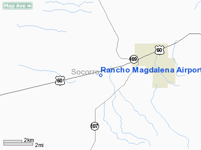
| Longitude/Latitude: | 107-17-51.0000W/34-05-51.0000N
-107.297500/34.097500 (Estimated) |
| Elevation: | 6676 ft / 2034.84 m (Estimated) |
| Land: | 0 acres |
| From nearest city: | 3 nautical miles W of Magdalena, NM |
| Location: | Socorro County, NM |
| Magnetic Variation: | () |
Owner & Manager
| Ownership: | Privately owned |
| Owner: | Lee Scholes |
| Address: | Po Box 1112
Magdalena, NM 87825 |
| Phone number: | 505-854-3090 |
| Manager: | Lee Scholes |
| Address: | Po Box 1112
Magdalena, NM 87825 |
| Phone number: | 505-854-3090 |
Airport Operations and Facilities
| Airport Use: | Private |
| Control Tower: | No |
| Sectional chart: | Albuquerque |
| Region: | ASW - Southwest |
| Boundary ARTCC: | ZAB - Albuquerque |
| Tie-in FSS: | ABQ - Albuquerque |
| FSS Toll Free: | 1-800-WX-BRIEF |
Runway Information
Runway 03/21
| Dimension: | 2200 x 30 ft / 670.6 x 9.1 m |
| Surface: | TURF, |
| |
Runway 03 |
Runway 21 |
| Traffic Pattern: | Left | Left |
| Obstruction: | 200 ft hill, 2000.0 ft from runway | 155 ft hill, 5280.0 ft from runway |
|
Radio Navigation Aids
| ID |
Type |
Name |
Ch |
Freq |
Var |
Dist |
| FIA | NDB | Florida | | 329.00 | 12E | 19.8 nm |
| ONM | VORTAC | Socorro | 115X | 116.80 | 13E | 27.8 nm |
| TCS | VORTAC | Truth Or Consequences | 074X | 112.70 | 13E | 49.0 nm |
Images and information placed above are from
http://www.airport-data.com/airport/NM01/
We thank them for the data!
|
|


