 |
|
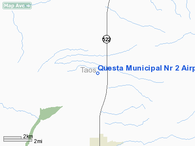
Location & QuickFacts
| FAA Information Effective: | 2008-09-25 |
| Airport Identifier: | N24 |
| Airport Status: | Operational |
| Longitude/Latitude: | 105-35-51.0000W/36-48-01.1000N
-105.597500/36.800306 (Estimated) |
| Elevation: | 7700 ft / 2346.96 m (Estimated) |
| Land: | 480 acres |
| From nearest city: | 6 nautical miles N of Questa, NM |
| Location: | Taos County, NM |
| Magnetic Variation: | 11E (1985) |
Owner & Manager
| Ownership: | Publicly owned |
| Owner: | Village Of Questa |
| Address: | Po Box 260
Questa, NM 87556 |
| Phone number: | 575-586-0694 |
| Manager: | Brent Jaramillo |
| Address: | Po Box 260
Questa, NM 87556 |
| Phone number: | 575-586-0694 |
Airport Operations and Facilities
| Airport Use: | Open to public |
| Wind indicator: | Yes |
| Segmented Circle: | Yes |
| Control Tower: | No |
| Lighting Schedule: | DUSK-DAWN
ACTVT MIRL RY 17/35 - 123.6. |
| Beacon Color: | Clear-Green (lighted land airport) |
| Sectional chart: | Denver |
| Region: | ASW - Southwest |
| Boundary ARTCC: | ZDV - Denver |
| Tie-in FSS: | ABQ - Albuquerque |
| FSS on Airport: | No |
| FSS Toll Free: | 1-800-WX-BRIEF |
| NOTAMs Facility: | ABQ (NOTAM-d service avaliable) |
| Federal Agreements: | NGY |
Airport Communications
Airport Services
Runway Information
Runway 17/35
| Dimension: | 6861 x 75 ft / 2091.2 x 22.9 m |
| Surface: | ASPH, Good Condition |
| Weight Limit: | Single wheel: 12500 lbs. |
| Edge Lights: | Medium |
| |
Runway 17 |
Runway 35 |
| Longitude: | 105-35-50.8990W | 105-35-51.0020W |
| Latitude: | 36-48-34.9530N | 36-47-27.1430N |
| Elevation: | 7667.00 ft | 7690.00 ft |
| Alignment: | 127 | 0 |
| Traffic Pattern: | Left | Left |
| Markings: | Basic, Good Condition | Basic, Good Condition |
|
Radio Navigation Aids
| ID |
Type |
Name |
Ch |
Freq |
Var |
Dist |
| SKX | NDB | Ski | | 414.00 | 11E | 20.9 nm |
| MVI | NDB | Monte Vista | | 311.00 | 11E | 48.7 nm |
| TAS | VORTAC | Taos | 123X | 117.60 | 13E | 18.8 nm |
| ALS | VORTAC | Alamosa | 086X | 113.90 | 13E | 34.6 nm |
| CIM | VORTAC | Cimarron | 111X | 116.40 | 13E | 39.6 nm |
Remarks
- ELK & LIVESTOCK ON & INVOF ARPT.
- FOR ACCESS ON & OFF AIRFIELD CTC VILLAGE OFFICE AT 575-586-0694.
- RY 17 PREFERRED CALM WIND RY.
- MOUNTAINS EAST AND SW OF ARPT.
Images and information placed above are from
http://www.airport-data.com/airport/N24/
We thank them for the data!
| General Info
|
| Country |
United States
|
| State |
NEW MEXICO
|
| FAA ID |
N24
|
| Latitude |
36-48-01.100N
|
| Longitude |
105-35-51.000W
|
| Elevation |
7700 feet
|
| Near City |
QUESTA
|
We don't guarantee the information is fresh and accurate. The data may
be wrong or outdated.
For more up-to-date information please refer to other sources.
|
|


