 |
|
| Lea County Regional Airport |
| IATA: HOB – ICAO: KHOB |
| Summary |
| Airport type |
Public |
| Operator |
Lea County |
| Location |
Hobbs, New Mexico |
| Elevation AMSL |
3,661 ft / 1,115.9 m |
| Coordinates |
32°41′15″N 103°13′01″W / 32.6875°N 103.21694°W / 32.6875; -103.21694Coordinates: 32°41′15″N 103°13′01″W / 32.6875°N 103.21694°W / 32.6875; -103.21694 |
| Runways |
| Direction |
Length |
Surface |
| ft |
m |
| 3/21 |
7,398 |
2,255 |
Asphalt |
| 8/26 |
3,512 |
1,070 |
Asphalt |
| 12/30 |
6,002 |
1,829 |
Asphalt |
| 17/35 |
4,998 |
1,523 |
Asphalt |
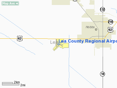
Lea County Regional Airport (IATA: HOB, ICAO: KHOB), also known as Lea County-Hobbs Airport, is a public airport located four miles (6.4 km) west of the central business district (CBD) of Hobbs, a city in Lea County, New Mexico, USA. The airport covers 898 acres (363 ha) and has four runways. It is mostly used for general aviation, but is also served by one commercial airline. Service is subsidized by the Essential Air Service program. Airline and destination
- New Mexico Airlines (Carlsbad, Midland/Odessa, Ruidoso)
History
The current Lea County Regional Airport was originally called the Me-Tex Airport and opened as a commercially operated airport on July 23, 1937. In 1937 the Me-Tex Supply Company leased the land where the airport is located from the State of New Mexico. Oiled runways were installed and a hangar constructed.
In 1940, the City of Hobbs passed a bond issue for funds to purchase the airport and some adjoining acreage, with the intent of bringing regular airline service and airmail delivery to the City. Federal grants helped pay for improvements such as paved runways and taxiways and a terminal building for the renamed Hobbs Municipal Airport.
The first air mail arrived in Hobbs via Continental Airlines in May 1940 which also initiated air passenger service that same year.
Ownership of the airport was transferred from the City of Hobbs to Lea County on November 19, 1945
Continental Airlines continued service to the airport until 1963, when they were replaced by Trans-Texas Airlines. Supplemental service was provided by Bison Airlines from 1963 to 1964.
The above content comes from Wikipedia and is published under free licenses – click here to read more.
Location & QuickFacts
| FAA Information Effective: | 2008-09-25 |
| Airport Identifier: | HOB |
| Airport Status: | Operational |
| Longitude/Latitude: | 103-13-01.3000W/32-41-15.1000N
-103.217028/32.687528 (Estimated) |
| Elevation: | 3661 ft / 1115.87 m (Surveyed) |
| Land: | 898 acres |
| From nearest city: | 4 nautical miles W of Hobbs, NM |
| Location: | Lea County, NM |
| Magnetic Variation: | 10E (1980) |
Owner & Manager
| Ownership: | Publicly owned |
| Owner: | Lea County |
| Address: | Courthouse Box 5c
Lovington, NM 88260 |
| Phone number: | 575-396-8521 |
| Manager: | Bill Gatchell |
| Address: | Box 1106
Hobbs, NM 88241 |
| Phone number: | 575-391-2934 |
Airport Operations and Facilities
| Airport Use: | Open to public |
| Wind indicator: | Yes |
| Segmented Circle: | Yes |
| Control Tower: | Yes |
| Lighting Schedule: | DUSK-DAWN
WHEN ATCT CLSD HIRL RY 03/21 & MIRL RY 12/30 PRESET LOW INTST; TO INCR INTST & ACTVT TWY LGTS - CTAF. ACTVT MALSR RY 03 & ODALS RY 21 - CTAF. |
| Beacon Color: | Clear-Green (lighted land airport)
ROTG BCN OTS INDEFLY. |
| Landing fee charge: | No |
| Sectional chart: | Albuquerque |
| Region: | ASW - Southwest |
| Boundary ARTCC: | ZFW - Fort Worth |
| Tie-in FSS: | ABQ - Albuquerque |
| FSS on Airport: | No |
| FSS Toll Free: | 1-800-WX-BRIEF |
| NOTAMs Facility: | HOB (NOTAM-d service avaliable) |
| Certification type/date: | II A S 09/198
CLSD TO ACR OPNS WITH MORE THAN 30 PSGR SEATS EXCP PPR CALL AMGR 575-391-2934. RY 17/35 NOT AVBL FOR ACR OPNS WITH OVER 9 PSGR SEATS. |
| Federal Agreements: | NGY3 |
Airport Communications
| CTAF: | 120.650 |
| Unicom: | 122.950 |
Airport Services
Runway Information
Runway 03/21
| Dimension: | 7398 x 150 ft / 2254.9 x 45.7 m |
| Surface: | ASPH, Good Condition |
| Surface Treatment: | Porous Friction Course |
| Weight Limit: | Single wheel: 65000 lbs.
Dual wheel: 100000 lbs. |
| Edge Lights: | High |
| |
Runway 03 |
Runway 21 |
| Longitude: | 103-13-33.1430W | 103-12-31.8270W |
| Latitude: | 32-40-43.2790N | 32-41-34.9310N |
| Elevation: | 3652.00 ft | 3646.00 ft |
| Alignment: | 45 | 127 |
| ILS Type: | ILS/DME
| |
| Traffic Pattern: | Left | Left |
| Markings: | Precision instrument, Good Condition | Non-precision instrument, Good Condition |
| Crossing Height: | 0.00 ft | 44.00 ft |
| VASI: | | 4-box on left side |
| Visual Glide Angle: | 0.00° | 3.00° |
| Approach lights: | MALSR | ODALS |
| Obstruction: | , 50:1 slope to clear | 34 ft tree, 824.0 ft from runway, 437 ft left of centerline, 18:1 slope to clear |
| Decleard distances: | Take off run available 7398.00 ft
Take off distance available 7398.00 ft
Actual stop distance available 7398.00 ft
Landing distance available 7398.00 ft
| Take off run available 7398.00 ft
Take off distance available 7398.00 ft
Actual stop distance available 7398.00 ft
Landing distance available 7398.00 ft
|
|
Runway 08/26
| Dimension: | 3512 x 150 ft / 1070.5 x 45.7 m |
| Surface: | ASPH, Fair Condition |
| Weight Limit: | Single wheel: 12000 lbs. |
| |
Runway 08 |
Runway 26 |
| Longitude: | 103-13-15.9250W | 103-12-34.8420W |
| Latitude: | 32-41-15.1370N | 32-41-15.0580N |
| Elevation: | 3653.00 ft | 3647.00 ft |
| Alignment: | 90 | 127 |
| Traffic Pattern: | Left | Left |
| Markings: | Basic, Poor Condition
RY MARKINGS FADED. | Basic, Poor Condition
RY MARKINGS FADED. |
| Obstruction: | 6 ft fence, 330.0 ft from runway, 21:1 slope to clear | , 50:1 slope to clear |
| Decleard distances: | Take off run available 3512.00 ft
Take off distance available 3512.00 ft
Actual stop distance available 3512.00 ft
Landing distance available 3512.00 ft
| Take off run available 3512.00 ft
Take off distance available 3512.00 ft
Actual stop distance available 3512.00 ft
Landing distance available 3512.00 ft
|
|
Runway 12/30
| Dimension: | 6002 x 150 ft / 1829.4 x 45.7 m |
| Surface: | ASPH, Good Condition |
| Weight Limit: | Single wheel: 90000 lbs.
Dual wheel: 120000 lbs. |
| Edge Lights: | Medium |
| |
Runway 12 |
Runway 30 |
| Longitude: | 103-13-16.6970W | 103-12-27.1410W |
| Latitude: | 32-41-38.0840N | 32-40-56.0270N |
| Elevation: | 3661.00 ft | 3638.00 ft |
| Alignment: | 127 | 127 |
| Traffic Pattern: | Left | Left |
| Markings: | Non-precision instrument, Good Condition | Non-precision instrument, Good Condition |
| Crossing Height: | 49.00 ft | 44.00 ft |
| VASI: | 4-box on left side | 4-light PAPI on right side |
| Visual Glide Angle: | 3.00° | 3.00° |
| Decleard distances: | Take off run available 6001.00 ft
Take off distance available 6001.00 ft
Actual stop distance available 6001.00 ft
Landing distance available 6001.00 ft
| Take off run available 6001.00 ft
Take off distance available 6001.00 ft
Actual stop distance available 6001.00 ft
Landing distance available 6001.00 ft
|
|
Runway 17/35
| Dimension: | 4998 x 100 ft / 1523.4 x 30.5 m |
| Surface: | ASPH, Good Condition |
| Weight Limit: | Single wheel: 32000 lbs.
Dual wheel: 50000 lbs. |
| |
Runway 17 |
Runway 35 |
| Longitude: | 103-13-14.9820W | 103-13-15.0930W |
| Latitude: | 32-41-46.1400N | 32-40-56.6940N |
| Elevation: | 3660.00 ft | 3650.00 ft |
| Alignment: | 127 | 0 |
| Traffic Pattern: | Left | Left |
| Markings: | Basic, Good Condition | Basic, Good Condition |
| Displaced threshold: | 492.00 ft | 0.00 ft |
| Obstruction: | 27 ft pline, 290.0 ft from runway, 3:1 slope to clear
APCH RATIO 38:1 TO DSPLCD THR.
+17 FT ROAD 150 FT FM THR & 5 FT FENCE 100 FT FM THR. | , 50:1 slope to clear |
| Decleard distances: | Take off run available 4998.00 ft
Take off distance available 4998.00 ft
Actual stop distance available 4998.00 ft
Landing distance available 4506.00 ft
| Take off run available 4998.00 ft
Take off distance available 4998.00 ft
Actual stop distance available 4998.00 ft
Landing distance available 4998.00 ft
|
|
Radio Navigation Aids
| ID |
Type |
Name |
Ch |
Freq |
Var |
Dist |
| GNC | NDB | Gaines County | | 344.00 | 09E | 28.9 nm |
| ANR | NDB | Andrews | | 245.00 | 09E | 40.1 nm |
| HOB | VORTAC | Hobbs | 047X | 111.00 | 11E | 4.0 nm |
| INK | VORTAC | Wink | 058X | 112.10 | 11E | 48.9 nm |
Remarks
- TWY E CLSD WEST OF TWY C AND EAST IF TWY D INDEFLY.
Images and information placed above are from
http://www.airport-data.com/airport/HOB/
We thank them for the data!
| General Info
|
| Country |
United States
|
| State |
NEW MEXICO
|
| FAA ID |
HOB
|
| Latitude |
32-41-15.100N
|
| Longitude |
103-13-01.300W
|
| Elevation |
3661 feet
|
| Near City |
HOBBS
|
We don't guarantee the information is fresh and accurate. The data may
be wrong or outdated.
For more up-to-date information please refer to other sources.
|
|


