 |
|
| Lea County-Jal Airport |
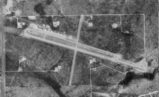 |
| USGS aerial image, 1997 (North is to the right) |
| IATA: none – ICAO: none – FAA LID: E26 |
| Summary |
| Airport type |
Public |
| Owner |
Lea County |
| Serves |
Jal, New Mexico |
| Elevation AMSL |
3,118 ft / 950 m |
| Coordinates |
32°07′52″N 103°09′17″W / 32.13111°N 103.15472°W / 32.13111; -103.15472 |
| Website |
leacounty.net/jalairport.htm |
| Runways |
| Direction |
Length |
Surface |
| ft |
m |
| 1/19 |
4,704 |
1,434 |
Asphalt |
| 9/27 |
2,604 |
794 |
Asphalt |
| Statistics (2008) |
| Aircraft operations |
4,200 |
| Based aircraft |
2 |
| Source: Federal Aviation Administration |
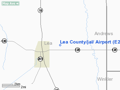
Lea County-Jal Airport (FAA LID: E26) is a county-owned public-use airport located three nautical miles (6 km) northeast of the central business district of Jal, a city in Lea County, New Mexico, United States.
This airport is included in the FAA's National Plan of Integrated Airport Systems (2009-2013), which categorizes it as a general aviation airport.
Facilities and aircraft
Lea County-Jal Airport covers an area of 320 acres (129 ha) at an elevation of 3,118 feet (950 m) above mean sea level. It has two asphalt paved runways: 1/19 is 4,704 by 60 feet (1,434 x 18 m) and 9/27 is 2,604 by 50 feet (794 x 15 m). For the 12-month period ending April 7, 2008, the airport had 4,200 aircraft operations, an average of 11 per day.
The above content comes from Wikipedia and is published under free licenses – click here to read more.
Location & QuickFacts
| FAA Information Effective: | 2008-09-25 |
| Airport Identifier: | E26 |
| Airport Status: | Operational |
| Longitude/Latitude: | 103-09-17.4620W/32-07-51.8820N
-103.154851/32.131078 (Estimated) |
| Elevation: | 3118 ft / 950.37 m (Surveyed) |
| Land: | 320 acres |
| From nearest city: | 3 nautical miles NE of Jal, NM |
| Location: | Lea County, NM |
| Magnetic Variation: | 09E (1985) |
Owner & Manager
| Ownership: | Publicly owned |
| Owner: | Lea County |
| Address: | Po Box 1106
Hobbs, NM 88241-1106 |
| Phone number: | 575-391-2934 |
| Manager: | Bill Gatchell
LEA CO/HOBBS/ ARPT MGR ALSO. |
| Address: | Po Box 1106
Hobbs, NM 88241-1106 |
| Phone number: | 575-391-2934 |
Airport Operations and Facilities
| Airport Use: | Open to public |
| Wind indicator: | Yes |
| Segmented Circle: | Yes |
| Control Tower: | No |
| Lighting Schedule: | DUSK-DAWN
MIRL RY 01/19 PRESET LOW INTST; TO INCR INTST ACTVT - CTAF. |
| Beacon Color: | Clear-Green (lighted land airport) |
| Landing fee charge: | No |
| Sectional chart: | Albuquerque |
| Region: | ASW - Southwest |
| Boundary ARTCC: | ZFW - Fort Worth |
| Tie-in FSS: | ABQ - Albuquerque |
| FSS on Airport: | No |
| FSS Toll Free: | 1-800-WX-BRIEF |
| NOTAMs Facility: | ABQ (NOTAM-d service avaliable) |
| Federal Agreements: | NGY |
Airport Communications
Airport Services
| Airframe Repair: | NONE |
| Power Plant Repair: | NONE |
| Bottled Oxygen: | NONE |
| Bulk Oxygen: | NONE |
Runway Information
Runway 01/19
| Dimension: | 4704 x 60 ft / 1433.8 x 18.3 m |
| Surface: | ASPH, Fair Condition |
| Weight Limit: | Single wheel: 23000 lbs. |
| Edge Lights: | Medium |
| |
Runway 01 |
Runway 19 |
| Longitude: | 103-09-25.3500W | 103-09-09.3700W |
| Latitude: | 32-07-30.8600N | 32-08-15.3800N |
| Elevation: | 3097.00 ft | 3104.00 ft |
| Alignment: | 17 | 127 |
| Traffic Pattern: | Left | Left |
| Markings: | Basic, Fair Condition | Basic, Fair Condition |
| Obstruction: | 30 ft pline, 825.0 ft from runway, 20:1 slope to clear | 10 ft trees, 300.0 ft from runway, 12:1 slope to clear |
|
Runway 09/27
| Dimension: | 2604 x 50 ft / 793.7 x 15.2 m |
| Surface: | ASPH, Good Condition |
| Weight Limit: | Single wheel: 12000 lbs. |
| |
Runway 09 |
Runway 27 |
| Longitude: | 103-09-32.5300W | 103-09-02.7600W |
| Latitude: | 32-07-52.0100N | 32-07-47.2800N |
| Elevation: | 3118.00 ft | 3097.00 ft |
| Alignment: | 101 | 127 |
| Traffic Pattern: | Left | Left |
| Markings: | Basic, Good Condition | Basic, Good Condition |
| Displaced threshold: | 40.00 ft | 45.00 ft |
| Obstruction: | 5 ft brush, 200.0 ft from runway
APCH SLOPE 10:1 TO DSPLCD THR FM +15 FT ROAD 160 FT.
+4 FT FENCE & ROAD 70 FT FM END; +4 FT GND AND BRUSH 10 FT RIGHT OF RY EDGE. | 30 ft pline, 880.0 ft from runway, 22:1 slope to clear
APCH SLOPE 28:1 TO DSPLCD THR FM +4 FT FENCE 115 FT.
+4 FT FENCE 15 FT FM RY END, +7 FT BRUSH 20 FT FM RY END. |
|
Radio Navigation Aids
| ID |
Type |
Name |
Ch |
Freq |
Var |
Dist |
| ANR | NDB | Andrews | | 245.00 | 09E | 34.1 nm |
| OHE | NDB | Monahans | | 214.00 | 09E | 35.6 nm |
| GNC | NDB | Gaines County | | 344.00 | 09E | 41.5 nm |
| MA | NDB | Farly | | 326.00 | 09E | 43.1 nm |
| PEQ | VOR/DME | Pecos | 055X | 111.80 | 11E | 45.2 nm |
| INK | VORTAC | Wink | 058X | 112.10 | 11E | 16.1 nm |
| HOB | VORTAC | Hobbs | 047X | 111.00 | 11E | 31.0 nm |
| MAF | VORTAC | Midland | 095X | 114.80 | 11E | 49.7 nm |
| MAF | VOT | Midland International | | 108.20 | | 49.7 nm |
Remarks
- 5 FT LINE OF SIGHT NOT AVBL BTN RYS 01/19 AND 09/27 ENDS.
- EXTENSIVE OIL WELL DRILLING ACTIVITY ON & INVOF ARPT.
- +20 FT PUMP JACK 990 FT FM THLD 50 FT RIGHT OF CENTERLINE.
- RY 09/27 +4-7 FT BRUSH 60 FT FM CNTRLN BOTH SIDES LENGTH OF RUNWAY.
Images and information placed above are from
http://www.airport-data.com/airport/E26/
We thank them for the data!
| General Info
|
| Country |
United States
|
| State |
NEW MEXICO
|
| FAA ID |
E26
|
| Latitude |
32-07-51.882N
|
| Longitude |
103-09-17.462W
|
| Elevation |
3118 feet
|
| Near City |
JAL
|
We don't guarantee the information is fresh and accurate. The data may
be wrong or outdated.
For more up-to-date information please refer to other sources.
|
|


