 |
|
| Gallup Municipal Airport |
| IATA: GUP – ICAO: KGUP – FAA LID: GUP |
| Summary |
| Airport type |
Public |
| Owner |
City of Gallup |
| Serves |
Gallup, New Mexico |
| Elevation AMSL |
6,472 ft / 1,973 m |
| Coordinates |
35°30′40″N 108°47′22″W / 35.51111°N 108.78944°W / 35.51111; -108.78944 |
| Website |
ci.gallup.nm.us/... |
| Runways |
| Direction |
Length |
Surface |
| ft |
m |
| 6/24 |
7,316 |
2,230 |
Asphalt |
| Statistics (2009) |
| Aircraft operations |
4,643 |
| Based aircraft |
23 |
| Source: Federal Aviation Administration |
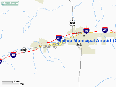
Gallup Municipal Airport (IATA: GUP, ICAO: KGUP, FAA LID: GUP) is a city-owned public-use airport located three nautical miles (6 km) southwest of the central business district of Gallup, a city in McKinley County, New Mexico, United States.
The airport is located on Historic Hwy 66. Full FBO services are provided by Gallup Flying Service. Gallup Med Flight operates Critical Care Air Transport Air Ambulance service.
In 2007 and early 2008, the airport was served by Great Lakes Airlines, with non-stop flights to Phoenix and flights to Denver via Farmington. and There is no scheduled commercial airline service at this time.
Facilities and aircraft
Gallup Municipal Airport covers an area of 359 acres (145 ha) at an elevation of 6,472 feet (1,973 m) above mean sea level. It has one asphalt paved runway designated 6/24 which measures 7,316 by 100 feet (2,230 x 30 m).
For the 12-month period ending March 31, 2009, the airport had 4,643 aircraft operations, an average of 12 per day: 58% air taxi, 26% general aviation, 12% scheduled commercial and 4% military. At that time there were 23 aircraft based at this airport: 57% single-engine and 43% multi-engine.
The above content comes from Wikipedia and is published under free licenses – click here to read more.
Location & QuickFacts
| FAA Information Effective: | 2008-09-25 |
| Airport Identifier: | GUP |
| Airport Status: | Operational |
| Longitude/Latitude: | 108-47-21.5140W/35-30-39.8100N
-108.789309/35.511058 (Estimated) |
| Elevation: | 6472 ft / 1972.67 m (Surveyed) |
| Land: | 359 acres |
| From nearest city: | 3 nautical miles SW of Gallup, NM |
| Location: | Mc Kinley County, NM |
| Magnetic Variation: | 12E (1985) |
Owner & Manager
| Ownership: | Publicly owned |
| Owner: | City Of Gallup |
| Address: | Box 1270
Gallup, NM 87305 |
| Phone number: | 505-863-1270 |
| Manager: | Stan Henderson |
| Address: | 110 West Aztec
Gallup, NM 87305 |
| Phone number: | 505-863-1290 |
Airport Operations and Facilities
| Airport Use: | Open to public |
| Wind indicator: | Yes |
| Segmented Circle: | Yes |
| Control Tower: | No |
| Lighting Schedule: | DUSK-DAWN
ACTVT MIRL RY 06/24 - CTAF. |
| Beacon Color: | Clear-Green (lighted land airport) |
| Landing fee charge: | No |
| Sectional chart: | Albuquerque |
| Region: | ASW - Southwest |
| Boundary ARTCC: | ZAB - Albuquerque |
| Tie-in FSS: | ABQ - Albuquerque |
| FSS on Airport: | No |
| FSS Toll Free: | 1-800-WX-BRIEF |
| NOTAMs Facility: | GUP (NOTAM-d service avaliable) |
| Federal Agreements: | NGY |
Airport Communications
| CTAF: | 122.950 |
| Unicom: | 122.950 |
Airport Services
| Fuel available: | 100LLA1+ |
| Airframe Repair: | MAJOR |
| Power Plant Repair: | MAJOR |
| Bottled Oxygen: | HIGH |
Runway Information
Runway 06/24
| Dimension: | 7316 x 100 ft / 2229.9 x 30.5 m |
| Surface: | ASPH, Good Condition |
| Weight Limit: | Single wheel: 45000 lbs.
Dual wheel: 55000 lbs. |
| Edge Lights: | Medium |
| |
Runway 06 |
Runway 24 |
| Longitude: | 108-48-03.9850W | 108-46-39.0010W |
| Latitude: | 35-30-29.7740N | 35-30-49.8500N |
| Elevation: | 6465.00 ft | 6472.00 ft |
| Alignment: | 74 | 127 |
| ILS Type: | LOC/DME
| |
| Traffic Pattern: | Left | Left |
| Markings: | Non-precision instrument, Fair Condition | Non-precision instrument, Fair Condition |
| Crossing Height: | 46.00 ft | 44.00 ft |
| VASI: | 2-light PAPI on left side | 2-light PAPI on left side |
| Visual Glide Angle: | 3.00° | 3.00° |
| Obstruction: | 35 ft tree, 1400.0 ft from runway, 34:1 slope to clear | 15 ft berm, 500.0 ft from runway, 20:1 slope to clear |
|
Radio Navigation Aids
| ID |
Type |
Name |
Ch |
Freq |
Var |
Dist |
| AWR | NDB | Window Rock | | 254.00 | 12E | 16.5 nm |
| GUP | VORTAC | Gallup | 098X | 115.10 | 14E | 4.6 nm |
| ZUN | VORTAC | Zuni | 081X | 113.40 | 14E | 37.4 nm |
Remarks
- FEE FOR SVC AFT HRS.
- GND EXPLOSIVES DEMOLITION OPNS 16 NM NW OF ARPT WEEKDAYS SR-SS.
Images and information placed above are from
http://www.airport-data.com/airport/GUP/
We thank them for the data!
| General Info
|
| Country |
United States
|
| State |
NEW MEXICO
|
| FAA ID |
GUP
|
| Latitude |
35-30-39.810N
|
| Longitude |
108-47-21.514W
|
| Elevation |
6472 feet
|
| Near City |
GALLUP
|
We don't guarantee the information is fresh and accurate. The data may
be wrong or outdated.
For more up-to-date information please refer to other sources.
|
|


