 |
|
Four Corners Rgnl Airport |
| Four Corners Regional Airport |
 |
| IATA: FMN – ICAO: KFMN – FAA LID: FMN |
| Summary |
| Airport type |
Public |
| Operator |
City of Farmington |
| Location |
Farmington, New Mexico |
| Elevation AMSL |
5,506 ft / 1,678.2 m |
| Coordinates |
36°44′28″N 108°13′48″W / 36.74111°N 108.23°W / 36.74111; -108.23Coordinates: 36°44′28″N 108°13′48″W / 36.74111°N 108.23°W / 36.74111; -108.23 |
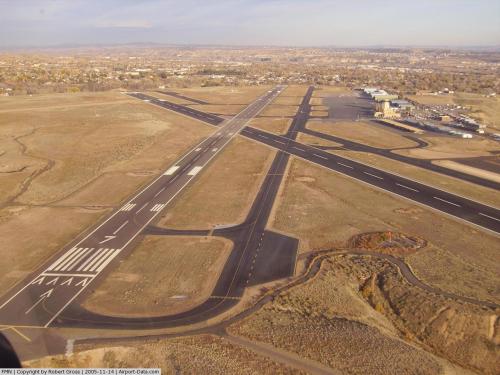
| Runways |
| Direction |
Length |
Surface |
| ft |
m |
| 5/23 |
6,500 |
1,981 |
Asphalt |
| 7/25 |
6,704 |
2,043 |
Asphalt |
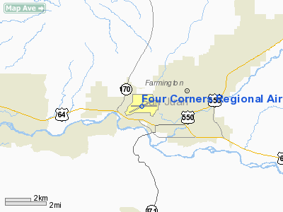
FAA airport diagram Four Corners Regional Airport (IATA: FMN, ICAO: KFMN, FAA LID: FMN) is a public airport located 1 miles (2 km) northwest of the central business district (CBD) of Farmington, a city in San Juan County, New Mexico, United States. Formerly Mesa Airlines provided flights to Albuquerque, however these were discontinued in 2007. The City of Farmington is currently in negotiations with New Mexico Airlines and Great Lakes Airlines to take over Mesa's service to Albuquerque.
Mesa Airlines was headquartered in Farmington, but eventually moved out of Farmington, canceling their last flight out of Farmington in August 2007. However, even after Mesa's headquarters moved, their pilot development program remained in Farmington.
Over the years, Four Corners Regional Airport has been served by the original Frontier Airlines, Sunwest Airlines, Air Midwest, Aspen Airways, Pioneer Airlines, Trans Colorado Airlines, America West Express, Continental Express, United Express, American Eagle, and USAirways Express.
Airlines and destinations
| Airlines |
Destinations |
| Great Lakes Airlines |
Denver, Kingman, Page, Prescott, Ontario |
The above content comes from Wikipedia and is published under free licenses – click here to read more.
 |
(Click on the photo to enlarge) |
Location & QuickFacts
| FAA Information Effective: | 2008-09-25 |
| Airport Identifier: | FMN |
| Airport Status: | Operational |
| Longitude/Latitude: | 108-13-47.8000W/36-44-28.5000N
-108.229944/36.741250 (Estimated) |
| Elevation: | 5506 ft / 1678.23 m (Surveyed) |
| Land: | 603 acres |
| From nearest city: | 1 nautical miles NW of Farmington, NM |
| Location: | San Juan County, NM |
| Magnetic Variation: | 12E (1985) |
Owner & Manager
| Ownership: | Publicly owned |
| Owner: | City Of Farmington |
| Address: | 800 Municipal Drive
Farmington, NM 87401 |
| Phone number: | 505-599-1100 |
| Manager: | Brent S. Shiner
ACTING AIRPORT DIRECTOR. |
| Address: | 800 Municipal Drive
Farmington, NM 87401 |
| Phone number: | 505-599-1394 |
Airport Operations and Facilities
| Airport Use: | Open to public |
| Wind indicator: | Yes |
| Segmented Circle: | Yes |
| Control Tower: | Yes |
| Lighting Schedule: | DUSK-DAWN
WHEN ATCT CLSD MIRL RY 07/25 & REIL RY 25 PRESET LOW INTST; TO INCR INTST & ACTVT MIRL RY 05/23 & REIL RY 23 - CTAF. |
| Beacon Color: | Clear-Green (lighted land airport) |
| Landing fee charge: | No |
| Sectional chart: | Denver |
| Region: | ASW - Southwest |
| Boundary ARTCC: | ZDV - Denver |
| Tie-in FSS: | ABQ - Albuquerque |
| FSS on Airport: | No |
| FSS Toll Free: | 1-800-WX-BRIEF |
| NOTAMs Facility: | FMN (NOTAM-d service avaliable) |
| Certification type/date: | III A S 05/19
PPR 24 HRS FOR UNSKED ACR OPNS WITH MORE THAN 30 PSGR SEATS CALL AMGR 505-599-1394. |
| Federal Agreements: | NGVY |
Airport Communications
| CTAF: | 118.900 |
| Unicom: | 122.950 |
Airport Services
| Fuel available: | 100LLA A1+ |
| Airframe Repair: | MAJOR |
| Power Plant Repair: | MAJOR |
| Bottled Oxygen: | LOW |
| Bulk Oxygen: | LOW |
Runway Information
Runway 05/23
| Dimension: | 6500 x 150 ft / 1981.2 x 45.7 m |
| Surface: | ASPH, Fair Condition |
| Surface Treatment: | Porous Friction Course |
| Weight Limit: | Single wheel: 47000 lbs.
Dual wheel: 66000 lbs. |
| Edge Lights: | Medium |
| |
Runway 05 |
Runway 23 |
| Longitude: | 108-14-29.2240W | 108-13-17.0680W |
| Latitude: | 36-44-14.3280N | 36-44-41.8340N |
| Elevation: | 5472.00 ft | 5504.00 ft |
| Alignment: | 65 | 127 |
| Traffic Pattern: | Left | Left |
| Markings: | Non-precision instrument, Good Condition | Non-precision instrument, Good Condition |
| Crossing Height: | 61.00 ft | 52.00 ft |
| Displaced threshold: | 0.00 ft | 124.00 ft |
| VASI: | 4-box on right side | 4-box on right side |
| Visual Glide Angle: | 3.00° | 3.00° |
| Runway End Identifier: | | Yes |
| Decleard distances: | Take off run available 6500.00 ft
Take off distance available 6900.00 ft
Actual stop distance available 6375.00 ft
Landing distance available 6375.00 ft
| Take off run available 6500.00 ft
Take off distance available 7500.00 ft
Actual stop distance available 6500.00 ft
Landing distance available 6375.00 ft
|
|
Runway 07/25
| Dimension: | 6704 x 100 ft / 2043.4 x 30.5 m |
| Surface: | ASPH, Good Condition |
| Surface Treatment: | Porous Friction Course |
| Weight Limit: | Single wheel: 50000 lbs.
Dual wheel: 90000 lbs. |
| Edge Lights: | Medium |
| |
Runway 07 |
Runway 25 |
| Longitude: | 108-14-23.7430W | 108-13-01.4330W |
| Latitude: | 36-44-27.9340N | 36-44-29.8850N |
| Elevation: | 5477.00 ft | 5503.00 ft |
| Alignment: | 88 | 127 |
| ILS Type: | | ILS/DME
|
| Traffic Pattern: | Left | Left |
| Markings: | Precision instrument, Good Condition | Precision instrument, Good Condition |
| Crossing Height: | 52.00 ft | 52.00 ft |
| Displaced threshold: | 239.00 ft | 188.00 ft |
| VASI: | 4-box on left side | 4-box on left side |
| Visual Glide Angle: | 3.00° | 3.00° |
| Runway End Identifier: | | Yes |
| Decleard distances: | Take off run available 6704.00 ft
Take off distance available 7704.00 ft
Actual stop distance available 6518.00 ft
Landing distance available 6277.00 ft
| Take off run available 6704.00 ft
Take off distance available 6704.00 ft
Actual stop distance available 6463.00 ft
Landing distance available 6277.00 ft
|
|
Radio Navigation Aids
| ID |
Type |
Name |
Ch |
Freq |
Var |
Dist |
| DRO | VOR/DME | Durango | 019X | 108.20 | 14E | 33.8 nm |
| CEZ | VOR/DME | Cortez | 021X | 108.40 | 14E | 42.1 nm |
| RSK | VORTAC | Rattlesnake | 100X | 115.30 | 14E | 6.3 nm |
Images and information placed above are from
http://www.airport-data.com/airport/FMN/
We thank them for the data!
| General Info
|
| Country |
United States
|
| State |
NEW MEXICO
|
| FAA ID |
FMN
|
| Latitude |
36-44-28.500N
|
| Longitude |
108-13-47.800W
|
| Elevation |
5506 feet
|
| Near City |
FARMINGTON
|
We don't guarantee the information is fresh and accurate. The data may
be wrong or outdated.
For more up-to-date information please refer to other sources.
|
|


