 |
|
Coordinates: 35°08′43″N 106°47′43″W / 35.14528°N 106.79528°W / 35.14528; -106.79528
| Double Eagle II Airport |
 |
| IATA: none – ICAO: KAEG – FAA LID: AEG |
| Summary |
| Airport type |
Public |
| Owner |
City of Albuquerque |
| Serves |
Albuquerque, New Mexico |
| Elevation AMSL |
5,837 ft / 1,779 m |
| Runways |
| Direction |
Length |
Surface |
| ft |
m |
| 4/22 |
7,400 |
2,256 |
Asphalt |
| 17/35 |
5,999 |
1,828 |
Asphalt |
| Statistics (2006) |
| Aircraft operations |
131,397 |
| Based aircraft |
254 |
| Source: Federal Aviation Administration |
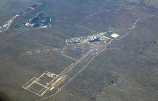
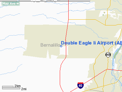
Double Eagle II Airport (ICAO: KAEG, FAA LID: AEG) is a public airport located seven miles (11 km) northwest of the central business district of Albuquerque, a city in Bernalillo County, New Mexico, United States. It is owned by the City of Albuquerque.
Located on the far west side of the city, it is Albuquerque’s second airport after Albuquerque International Sunport. Construction began in 1982, and the airport was named for the Double Eagle II Balloon, the first balloon to cross the Atlantic ocean, piloted by Ben Abruzzo, Maxie Anderson, and Larry Newman.
Although most U.S. airports use the same three-letter location identifier for the FAA and IATA, Double Eagle II is assigned AEG by the FAA but has no designation from the IATA (which assigned AEG to Aek Godang Airport in Padang Sidempuan, Sumatra, Indonesia).
Air ambulance, corporate flights, military flights, training flights, charter, and private make up approximately 120,000 annual operations.
Utilicraft Aerospace Industries has announced that, together with the Navajo Nation, the city, and the State of New Mexico, it is building the FF-1080 Freight Feeder, a small cargo aircraft. Double Eagle II will be the final assembly point. Facilities and aircraft
Double Eagle II Airport covers an area of 4,257 acres (1,723 ha) which contains two asphalt paved runways:
- Runway 4/22 - 7,400 x 100 ft (2,256 x 30 m). Full ILS & MALSR (22 end); PAPI visual navigational aide
- Runway 17/35 - 5,999 x 100 ft (1,828 x 30 m). REIL (each end); PAPI visual navigational aide
Traffic pattern altitude is 6,800' mean sea level. Right hand traffic patterns for runways 22 and 35.
For the 12-month period ending April 30, 2006, the airport had 131,397 aircraft operations, an average of 359 per day: 97% general aviation, 2% air taxi and 1% military. There are 254 aircraft based at this airport: 83% single-engine, 8% multi-engine, 7% helicopter, 2% ultralight and <1% jet.
Filming location
Scenes for the pilot episode of the television series Terminator: The Sarah Connor Chronicles were filmed on location at Double Eagle II Airport. For the filming, the airport's sign was partially covered with a new sign stating the fictional name, "Red Valley Regional Airport", but the lower portion of the sign stating the actual latitude, longitude, and elevation of the airport was left uncovered.
The above content comes from Wikipedia and is published under free licenses – click here to read more.
Location & QuickFacts
| FAA Information Effective: | 2008-09-25 |
| Airport Identifier: | AEG |
| Airport Status: | Operational |
| Longitude/Latitude: | 106-47-42.6000W/35-08-42.6000N
-106.795167/35.145167 (Estimated) |
| Elevation: | 5837 ft / 1779.12 m (Surveyed) |
| Land: | 4257 acres |
| From nearest city: | 7 nautical miles NW of Albuquerque, NM |
| Location: | Bernalillo County, NM |
| Magnetic Variation: | 11E (1990) |
Owner & Manager
| Ownership: | Publicly owned |
| Owner: | City Of Albuquerque |
| Address: | Po Box 9948
Albuquerque, NM 87119 |
| Phone number: | 505-244-7899 |
| Manager: | Mike Medley |
| Address: | Po Box 9948
Albuquerque, NM 87119 |
| Phone number: | 505-244-7888 |
Airport Operations and Facilities
| Airport Use: | Open to public |
| Wind indicator: | Yes |
| Segmented Circle: | Yes |
| Control Tower: | No |
| Lighting Schedule: | DUSK-DAWN
ACTVT MIRL RYS 04/22 & 17/35; REIL RYS 17 & 35; MALSR RY 22; PAPI RYS 04 & 17 - CTAF. |
| Beacon Color: | Clear-Green (lighted land airport) |
| Sectional chart: | Albuquerque |
| Region: | ASW - Southwest |
| Boundary ARTCC: | ZAB - Albuquerque |
| Tie-in FSS: | ABQ - Albuquerque |
| FSS Toll Free: | 1-800-WX-BRIEF |
| NOTAMs Facility: | AEG (NOTAM-d service avaliable) |
| Federal Agreements: | NGY |
Airport Communications
| CTAF: | 122.800 |
| Unicom: | 122.800
AUTOMATED UNICOM: 3 CLICKS FOR BASIC ARPT ADVISORY, 3 MORE CLICKS FOR EXTENDED ADVISORY, 4 CLICKS FOR RADIO CHECK. |
Airport Services
| Fuel available: | 100LLA |
| Airframe Repair: | MAJOR |
| Power Plant Repair: | MAJOR |
| Bottled Oxygen: | HIGH |
Runway Information
Runway 04/22
| Dimension: | 7398 x 100 ft / 2254.9 x 30.5 m |
| Surface: | ASPH, Good Condition |
| Weight Limit: | Single wheel: 30000 lbs. |
| Edge Lights: | Medium |
| |
Runway 04 |
Runway 22 |
| Longitude: | 106-48-33.0509W | 106-47-28.7929W |
| Latitude: | 35-08-19.4995N | 35-09-10.1508N |
| Elevation: | 5837.00 ft | 5810.00 ft |
| Alignment: | 46 | 127 |
| ILS Type: | | ILS
|
| Traffic Pattern: | Left | Right |
| Markings: | Precision instrument, Good Condition | Precision instrument, Good Condition |
| Crossing Height: | 44.00 ft | 0.00 ft |
| VASI: | 4-light PAPI on left side | |
| Visual Glide Angle: | 3.00° | 0.00° |
| Approach lights: | | MALSR |
|
Runway 17/35
| Dimension: | 5993 x 100 ft / 1826.7 x 30.5 m |
| Surface: | ASPH, |
| Weight Limit: | Single wheel: 30000 lbs. |
| Edge Lights: | Medium |
| |
Runway 17 |
Runway 35 |
| Longitude: | 106-47-19.9950W | 106-47-19.9330W |
| Latitude: | 35-09-09.3717N | 35-08-10.1119N |
| Elevation: | 5806.00 ft | 5799.00 ft |
| Alignment: | 127 | 127 |
| Traffic Pattern: | Left | Right |
| Markings: | Non-precision instrument, Good Condition | Non-precision instrument, Good Condition |
| Crossing Height: | 44.00 ft | 0.00 ft |
| VASI: | 4-light PAPI on left side | |
| Visual Glide Angle: | 3.00° | 0.00° |
| Runway End Identifier: | Yes | Yes |
|
Radio Navigation Aids
| ID |
Type |
Name |
Ch |
Freq |
Var |
Dist |
| ILT | NDB | Isleta | | 247.00 | 11E | 12.8 nm |
| OTO | VOR | Otto | | 114.00 | 13E | 42.5 nm |
| ABQ | VORTAC | Albuquerque | 079X | 113.20 | 13E | 6.2 nm |
| SAF | VORTAC | Santa Fe | 043X | 110.60 | 13E | 43.0 nm |
| ONM | VORTAC | Socorro | 115X | 116.80 | 13E | 48.5 nm |
| ABQ | VOT | Albuquerque Intl | | 111.00 | | 11.1 nm |
Remarks
- FBO BODE AVIATION 505-352-0292 - 0500-2100; WEST MESA AVIATION 505-831-2359 - 0600-1800.
Images and information placed above are from
http://www.airport-data.com/airport/AEG/
We thank them for the data!
| General Info
|
| Country |
United States
|
| State |
NEW MEXICO
|
| FAA ID |
AEG
|
| Latitude |
35-08-42.550N
|
| Longitude |
106-47-42.582W
|
| Elevation |
5837 feet
|
| Near City |
ALBUQUERQUE
|
We don't guarantee the information is fresh and accurate. The data may
be wrong or outdated.
For more up-to-date information please refer to other sources.
|
|


