 |
|
| Crownpoint Airport |
| IATA: none – ICAO: none – FAA LID: 0E8 |
| Summary |
| Airport type |
The Navajo Nation |
| Operator |
Crownpoint, New Mexico |
| Location |
6,696 |
| Elevation AMSL |
2,041 ft / m |
| Coordinates |
35°43′04″N 108°12′06″W / 35.71778°N 108.20167°W / 35.71778; -108.20167Coordinates: 35°43′04″N 108°12′06″W / 35.71778°N 108.20167°W / 35.71778; -108.20167 |
| Runways |
| Direction |
Length |
Surface |
| ft |
m |
| 18/36 |
5,820 |
1,774 |
Asphalt |
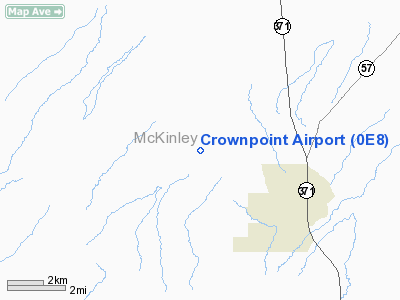
Crownpoint Airport (FAA LID: 0E8) is a public airport located three miles (5 km) northwest of the central business district of Crownpoint, in McKinley County, New Mexico, United States.
This is one of six airports owned by the Navajo Nation; the others being Shiprock Airport (5V5) in New Mexico, plus Chinle Airport (E91), Kayenta Airport (0V7), Tuba City Airport (T03) and Window Rock Airport (RQE) in Arizona.
Facilities
Crownpoint Airport covers an area of 22 acres (9 ha) and has one runway:
- Runway 18/36: 5,820 x 60 ft (1,774 x 18 m), Surface: Asphalt
The above content comes from Wikipedia and is published under free licenses – click here to read more.
Location & QuickFacts
| FAA Information Effective: | 2008-09-25 |
| Airport Identifier: | 0E8 |
| Airport Status: | Operational |
| Longitude/Latitude: | 108-12-05.7460W/35-43-03.5720N
-108.201596/35.717659 (Estimated) |
| Elevation: | 6696 ft / 2040.94 m (Surveyed) |
| Land: | 22 acres |
| From nearest city: | 3 nautical miles NW of Crownpoint, NM |
| Location: | Mc Kinley County, NM |
| Magnetic Variation: | 12E (1985) |
Owner & Manager
| Ownership: | Publicly owned |
| Owner: | Navajo Tribe |
| Address: | Hwy 264 Hogan Tso Building
Window Rock, AZ 86515 |
| Phone number: | 928-871-6498
ALTERNATE PHONE 520-871-6498. |
| Manager: | David Warren |
| Address: | Po Box 4620
Window Rock, AZ 86515 |
| Phone number: | 928-797-1684 |
Airport Operations and Facilities
| Airport Use: | Open to public |
| Wind indicator: | Yes |
| Segmented Circle: | Yes |
| Control Tower: | No |
| Lighting Schedule: | DUSK-DAWN
ACTVT MIRL RY 18/36 - 122.9. |
| Beacon Color: | Clear-Green (lighted land airport) |
| Landing fee charge: | No |
| Sectional chart: | Denver |
| Region: | ASW - Southwest |
| Boundary ARTCC: | ZAB - Albuquerque |
| Tie-in FSS: | ABQ - Albuquerque |
| FSS on Airport: | No |
| FSS Toll Free: | 1-800-WX-BRIEF |
| NOTAMs Facility: | ABQ (NOTAM-d service avaliable) |
| Federal Agreements: | NGY |
Airport Communications
Runway Information
Runway 18/36
| Dimension: | 5820 x 60 ft / 1773.9 x 18.3 m |
| Surface: | ASPH, Good Condition |
| Edge Lights: | Medium |
| |
Runway 18 |
Runway 36 |
| Longitude: | 108-11-57.4070W | 108-12-14.0860W |
| Latitude: | 35-43-31.5350N | 35-42-35.6090N |
| Elevation: | 6689.00 ft | 6696.00 ft |
| Alignment: | 127 | 14 |
| Traffic Pattern: | Left | Left |
| Markings: | Basic, Good Condition | Basic, Good Condition |
| Crossing Height: | 40.00 ft | 0.00 ft |
| VASI: | pulsating/steady burning on left side | |
| Visual Glide Angle: | 3.00° | 0.00° |
| Obstruction: | 43 ft hill, 1500.0 ft from runway, 30:1 slope to clear
+8 FT BERM 0-200 FT FROM THLD 81 FT RIGHT. | 32 ft pline, 900.0 ft from runway, 21:1 slope to clear |
|
Radio Navigation Aids
| ID |
Type |
Name |
Ch |
Freq |
Var |
Dist |
| AWR | NDB | Window Rock | | 254.00 | 12E | 42.4 nm |
| GUP | VORTAC | Gallup | 098X | 115.10 | 14E | 35.9 nm |
Remarks
- PPR 505-786-5291 ASK FOR SECURITY.
- ARPT GATE ENTRANCE PADLOCK COMBINATION IS 6708.
- PRVDD RWY LCTD TO PRVD 20:1 APCH/DEP CLNC OVER ELECTRICAL TRANSMISSION LINE SOUTH END.
Images and information placed above are from
http://www.airport-data.com/airport/0E8/
We thank them for the data!
| General Info
|
| Country |
United States
|
| State |
NEW MEXICO
|
| FAA ID |
0E8
|
| Latitude |
35-43-03.572N
|
| Longitude |
108-12-05.746W
|
| Elevation |
6696 feet
|
| Near City |
CROWNPOINT
|
We don't guarantee the information is fresh and accurate. The data may
be wrong or outdated.
For more up-to-date information please refer to other sources.
|
|


