 |
|
Conchas Lake Seaplane Base Airport |
| Conchas Lake Seaplane Base |
| IATA: none – ICAO: none – FAA LID: E61 |
| Summary |
| Airport type |
Public |
| Owner |
U.S. Army Corps of Engineers |
| Serves |
Conchas Dam, New Mexico |
| Elevation AMSL |
4,201 ft / 1,280 m |
| Coordinates |
35°23′03″N 104°12′59″W / 35.38417°N 104.21639°W / 35.38417; -104.21639 |
| Runways |
| Direction |
Length |
Surface |
| ft |
m |
| ALL/WAY |
21,120 |
6,437 |
Water |
| Source: Federal Aviation Administration |
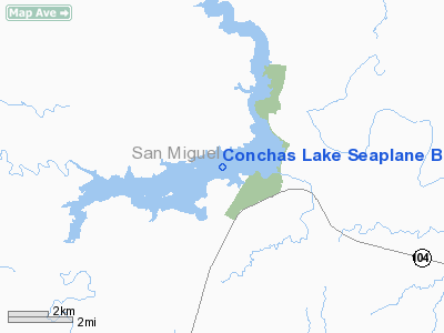
Conchas Lake Seaplane Base (FAA LID: E61) is a public use seaplane base located two nautical miles (4 km) southwest of the central business district of Conchas Dam, in San Miguel County, New Mexico, United States. It is owned by the U.S. Army Corps of Engineers. It has one seaplane landing area measuring 21,120 by 1,320 feet (6,437 by 402 m).
The above content comes from Wikipedia and is published under free licenses – click here to read more.
Location & QuickFacts
| FAA Information Effective: | 2008-09-25 |
| Airport Identifier: | E61 |
| Airport Status: | Operational |
| Longitude/Latitude: | 104-12-58.9150W/35-23-03.1750N
-104.216365/35.384215 (Estimated) |
| Elevation: | 4201 ft / 1280.46 m (Estimated) |
| Land: | 0 acres |
| From nearest city: | 2 nautical miles SW of Conchas Dam, NM |
| Location: | San Miguel County, NM |
| Magnetic Variation: | 10E (1985) |
Owner & Manager
| Ownership: | Publicly owned |
| Owner: | Abq Dist;us Army Corps Of Eng |
| Address: | Po Box 1008
Conchas Dam, NM 88416 |
| Phone number: | 505-868-2221 |
| Manager: | Gary Cordova |
| Address: | Po Box 1008
Conchas Dam, NM 88416 |
| Phone number: | 505-868-2221 |
Airport Operations and Facilities
| Airport Use: | Open to public |
| Wind indicator: | Yes |
| Segmented Circle: | No |
| Control Tower: | No |
| Landing fee charge: | No |
| Sectional chart: | Albuquerque |
| Region: | ASW - Southwest |
| Boundary ARTCC: | ZAB - Albuquerque |
| Tie-in FSS: | ABQ - Albuquerque |
| FSS on Airport: | No |
| FSS Toll Free: | 1-800-WX-BRIEF |
| NOTAMs Facility: | ABQ (NOTAM-d service avaliable) |
Airport Communications
Runway Information
Runway ALL/WAY
| Dimension: | 21120 x 1320 ft / 6437.4 x 402.3 m |
| Surface: | WATER, |
| |
Runway ALL |
Runway WAY |
| Traffic Pattern: | Left | Left |
|
Radio Navigation Aids
| ID |
Type |
Name |
Ch |
Freq |
Var |
Dist |
| TCC | VORTAC | Tucumcari | 083X | 113.60 | 12E | 32.7 nm |
| ACH | VORTAC | Anton Chico | 125X | 117.80 | 12E | 43.6 nm |
| FTI | VORTAC | Fort Union | 120X | 117.30 | 13E | 47.9 nm |
Remarks
- SMALL BOAT TRAFFIC HEAVY IN LANDING AREA MAY-OCT.
- LAKE LEVEL FLUCTUATES FM 4155 FT TO 4201 FT MSL. LNDG AREA BECOMES HAZARDOUS DUE TO EXPOSED SNAGS & LAND MASSES AT LEVELS BELOW 4170 FT.
- SEAPLANE OPERATIONS ARE PROHIBITED ON THAT PORTION OF THE LAKE NORTH OF THE DAM.
- WIND WARNING LGTS LCTD ON DAM, AT CENTRAL RECREATION AREA & AT SOUTH DOCK. LIGHTS FLASH IF WINDS ARE GREATER THAN 20 MPH.
- MOST WINDS OUT OF SW. RECOMMEND LNDG AND TKOF OPNS TO THE WEST.
- MOST OPNS DURING SCHEDULED FLY-INS & HOLS.
Images and information placed above are from
http://www.airport-data.com/airport/E61/
We thank them for the data!
| General Info
|
| Country |
United States
|
| State |
NEW MEXICO
|
| FAA ID |
E61
|
| Latitude |
35-23-03.175N
|
| Longitude |
104-12-58.915W
|
| Elevation |
4201 feet
|
| Near City |
CONCHAS DAM
|
We don't guarantee the information is fresh and accurate. The data may
be wrong or outdated.
For more up-to-date information please refer to other sources.
|
|


