 |
|
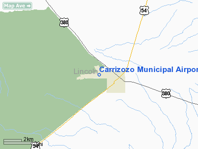
| Carrizozo Municipal Airport |
| IATA: F37 – ICAO: none |
| Summary |
| Airport type |
Public |
| Location |
Carrizozo, New Mexico |
| Elevation AMSL |
5,371 ft / 1,637 m |
| Coordinates |
33°38′55.901″N 105°53′44.466″W / 33.64886139°N 105.895685°W / 33.64886139; -105.895685Coordinates: 33°38′55.901″N 105°53′44.466″W / 33.64886139°N 105.895685°W / 33.64886139; -105.895685 |
| Runways |
| Direction |
Length |
Surface |
| ft |
m |
| 6/24 |
4,900 |
1,494 |
Asphalt |
| 15/33 |
2,500 |
762 |
Asphalt |
Carrizozo Municipal Airport (IATA: F37) is located in Carrizozo, New Mexico, serving Lincoln County.
The above content comes from Wikipedia and is published under free licenses – click here to read more.
Location & QuickFacts
| FAA Information Effective: | 2008-09-25 |
| Airport Identifier: | F37 |
| Airport Status: | Operational |
| Longitude/Latitude: | 105-53-44.4660W/33-38-55.9010N
-105.895685/33.648861 (Estimated) |
| Elevation: | 5371 ft / 1637.08 m (Estimated) |
| Land: | 204 acres |
| From nearest city: | 1 nautical miles NW of Carrizozo, NM |
| Location: | Lincoln County, NM |
| Magnetic Variation: | 11E (1985) |
Owner & Manager
| Ownership: | Publicly owned |
| Owner: | Town Of Carrizozo |
| Address: | Po Box 247
Carrizozo, NM 88301 |
| Phone number: | 575-648-2371 |
| Manager: | Bill Hayes |
| Address: | Po Box 597
Carrizozo, NM 88301 |
| Phone number: | 575-648-9996 |
Airport Operations and Facilities
| Airport Use: | Open to public |
| Wind indicator: | Yes |
| Segmented Circle: | Yes |
| Control Tower: | No |
| Lighting Schedule: | DUSK-DAWN
ACTVT MIRL RY 06/24, PAPI & REIL RYS 06 & 24 - CTAF. |
| Beacon Color: | Clear-Green (lighted land airport) |
| Landing fee charge: | No |
| Sectional chart: | Albuquerque |
| Region: | ASW - Southwest |
| Boundary ARTCC: | ZAB - Albuquerque |
| Tie-in FSS: | ABQ - Albuquerque |
| FSS on Airport: | No |
| FSS Toll Free: | 1-800-WX-BRIEF |
| NOTAMs Facility: | ABQ (NOTAM-d service avaliable) |
| Federal Agreements: | NGY |
Airport Communications
| CTAF: | 122.800 |
| Unicom: | 122.800 |
Airport Services
| Fuel available: | 100LL |
| Airframe Repair: | MINOR |
| Power Plant Repair: | MINOR |
| Bottled Oxygen: | NONE |
| Bulk Oxygen: | NONE |
Runway Information
Runway 06/24
| Dimension: | 4900 x 75 ft / 1493.5 x 22.9 m |
| Surface: | ASPH, |
| Weight Limit: | Single wheel: 12000 lbs. |
| Edge Lights: | Medium |
| |
Runway 06 |
Runway 24 |
| Longitude: | 105-54-15.1200W | 105-53-21.2000W |
| Latitude: | 33-38-44.8000N | 33-39-02.6000N |
| Elevation: | 5348.00 ft | 5355.00 ft |
| Alignment: | 68 | 127 |
| Traffic Pattern: | Left | Left |
| Markings: | Basic, Good Condition | Basic, Good Condition |
| Crossing Height: | 37.00 ft | 37.00 ft |
| VASI: | 4-light PAPI on left side | 4-light PAPI on left side |
| Visual Glide Angle: | 3.00° | 3.00° |
| Runway End Identifier: | Yes | Yes |
| Obstruction: | 10 ft road, 523.0 ft from runway, 32:1 slope to clear | 20 ft trees, 308.0 ft from runway, 37 ft right of centerline, 5:1 slope to clear |
|
Runway 15/33
| Dimension: | 2500 x 90 ft / 762.0 x 27.4 m |
| Surface: | DIRT, Good Condition |
| |
Runway 15 |
Runway 33 |
| Longitude: | 105-53-32.4000W | 105-53-32.0500W |
| Latitude: | 33-39-11.8000N | 33-38-48.6300N |
| Elevation: | 5339.00 ft | 5370.00 ft |
| Alignment: | 127 | 127 |
| Traffic Pattern: | Left | Left |
| Obstruction: | 5 ft fence, 200.0 ft from runway, 40:1 slope to clear | 200 ft ant, 3967.0 ft from runway, 120 ft left of centerline, 19:1 slope to clear |
|
Radio Navigation Aids
| ID |
Type |
Name |
Ch |
Freq |
Var |
Dist |
| CEP | NDB | Capitan | | 278.00 | 10E | 26.4 nm |
| ALM | NDB | Alamogordo | | 341.00 | 11E | 48.2 nm |
| HMN | TACAN | Holloman | 092X | | 10E | 48.5 nm |
| CNX | VORTAC | Corona | 102X | 115.50 | 13E | 44.5 nm |
Images and information placed above are from
http://www.airport-data.com/airport/F37/
We thank them for the data!
| General Info
|
| Country |
United States
|
| State |
NEW MEXICO
|
| FAA ID |
F37
|
| Time |
UTC-7(-6DT)
|
| Latitude |
33.648861
33° 38' 55.90" N
|
| Longitude |
-105.895686
105° 53' 44.47" W
|
| Elevation |
5371 feet
1637 meters
|
| Magnetic Variation |
009° E (01/06)
|
| Beacon |
Yes
|
| Operating Agency |
U.S.CIVIL AIRPORT WHEREIN PERMIT COVERS USE BY TRANSIT MILITARY AIRCRAFT
|
| Operating Hours |
24 HOUR OPERATIONS
|
| Daylight Saving Time |
Second Sunday in March at 0200 to first Sunday in November at 0200 local time (Exception Arizona and that portion of Indiana in the Eastern Time Zone)
|
We don't guarantee the information is fresh and accurate. The data may
be wrong or outdated.
For more up-to-date information please refer to other sources.
|
|


