 |
|
| Black Rock Airport |
| IATA: none – ICAO: KZUN – FAA LID: ZUN |
| Summary |
| Airport type |
Public |
| Owner |
Pueblo of Zuñi |
| Serves |
Zuni Pueblo, New Mexico |
| Elevation AMSL |
6,454 ft / 1,967 m |
| Coordinates |
35°04′59″N 108°47′30″W / 35.08306°N 108.79167°W / 35.08306; -108.79167 |
| Runways |
| Direction |
Length |
Surface |
| ft |
m |
| 6/24 |
4,807 |
1,465 |
Asphalt |
| Statistics (2009) |
| Aircraft operations |
110 |
| Source: Federal Aviation Administration |
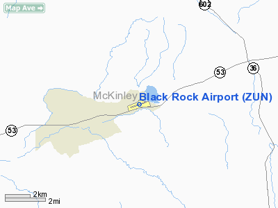
Black Rock Airport (ICAO: KZUN, FAA LID: ZUN) is a public use airport located three nautical miles (6 km) northeast of the central business district of Zuni Pueblo, a pueblo in McKinley County, New Mexico, United States. It is owned by the Pueblo of Zuñi. According to the FAA's National Plan of Integrated Airport Systems for 2009–2013, it is classified as a general aviation airport.
Although many U.S. airports use the same three-letter location identifier for the FAA and IATA, this airport is assigned ZUN by the FAA but has no designation from the IATA (which assigned ZUN to Union Station in Chicago, Illinois).
Facilities and aircraft
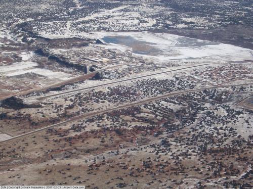
Black Rock Airport covers an area of 88 acres (36 ha) at an elevation of 6,454 feet (1,967 m) above mean sea level. It has one runway designated 6/24 with a packed dirt surface measuring 4,807 by 50 feet (1,465 x 15 m). For the 12-month period ending March 31, 2009, the airport had 110 aircraft operations: 91% air taxi and 9% general aviation.
The above content comes from Wikipedia and is published under free licenses – click here to read more.
 |
(Click on the photo to enlarge) |
Location & QuickFacts
| FAA Information Effective: | 2008-09-25 |
| Airport Identifier: | ZUN |
| Airport Status: | Operational |
| Longitude/Latitude: | 108-47-30.3970W/35-04-59.6170N
-108.791777/35.083227 (Estimated) |
| Elevation: | 6454 ft / 1967.18 m (Surveyed) |
| Land: | 88 acres |
| From nearest city: | 3 nautical miles NE of Zuni Pueblo, NM |
| Location: | Mc Kinley County, NM |
| Magnetic Variation: | 11E (2005) |
Owner & Manager
| Ownership: | Publicly owned |
| Owner: | Pueblo Of Zuni |
| Address: | Po Box 339
Zuni, NM 87327 |
| Phone number: | 505-782-7000 |
| Manager: | Calvert Martinez |
| Address: | Po Box 339
Zuni, NM 87327 |
| Phone number: | 505-782-7000 |
Airport Operations and Facilities
| Airport Use: | Open to public |
| Wind indicator: | Yes |
| Segmented Circle: | No |
| Control Tower: | No |
| Lighting Schedule: | DUSK-DAWN |
| Beacon Color: | Clear-Green (lighted land airport)
ROTG BCN OTS INDEFLY. |
| Landing fee charge: | No |
| Sectional chart: | Albuquerque |
| Region: | ASW - Southwest |
| Boundary ARTCC: | ZAB - Albuquerque |
| Tie-in FSS: | ABQ - Albuquerque |
| FSS on Airport: | No |
| FSS Toll Free: | 1-800-WX-BRIEF |
| NOTAMs Facility: | ABQ (NOTAM-d service avaliable) |
| Federal Agreements: | NGY |
Airport Communications
Airport Services
| Airframe Repair: | NONE |
| Power Plant Repair: | NONE |
Runway Information
Runway 06/24
| Dimension: | 4807 x 50 ft / 1465.2 x 15.2 m |
| Surface: | ASPH, Fair Condition
LARGE BUMPS AT 1000 FT & 1200 FT FM EAST END OF RY 24. |
| Edge Lights: | Low
LIRL OTS INDEFLY. |
| |
Runway 06 |
Runway 24 |
| Longitude: | 108-47-57.9950W | 108-47-02.8960W |
| Latitude: | 35-04-52.3760N | 35-05-06.8520N |
| Elevation: | 6434.00 ft | 6449.00 ft |
| Alignment: | 72 | 127 |
| Traffic Pattern: | Left | Left |
| Markings: | Basic, Poor Condition
RY MARKINGS FADED. | Basic, Poor Condition
RY MARKINGS FADED. |
| Obstruction: | 10 ft trees, 245.0 ft from runway, 4:1 slope to clear
4 FT BUSH 150 FT FROM THLD 75 FT RIGHT. | 30 ft trees, 210.0 ft from runway
+4' FENCE 150' FM THR; +15' ROAD 180' FM THR 50' R. |
|
Radio Navigation Aids
| ID |
Type |
Name |
Ch |
Freq |
Var |
Dist |
| AWR | NDB | Window Rock | | 254.00 | 12E | 37.5 nm |
| ZUN | VORTAC | Zuni | 081X | 113.40 | 14E | 19.2 nm |
| GUP | VORTAC | Gallup | 098X | 115.10 | 14E | 23.9 nm |
| SJN | VORTAC | St Johns | 070X | 112.30 | 12E | 43.3 nm |
Remarks
- PEDESTRIANS AND UNCONTROLLED VEHICULAR TFC CROSSING RY.
Images and information placed above are from
http://www.airport-data.com/airport/ZUN/
We thank them for the data!
| General Info
|
| Country |
United States
|
| State |
NEW MEXICO
|
| FAA ID |
ZUN
|
| Latitude |
35-04-59.617N
|
| Longitude |
108-47-30.397W
|
| Elevation |
6454 feet
|
| Near City |
ZUNI PUEBLO
|
We don't guarantee the information is fresh and accurate. The data may
be wrong or outdated.
For more up-to-date information please refer to other sources.
|
|


