 |
|
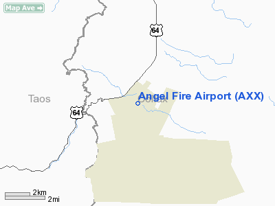
Location & QuickFacts
| FAA Information Effective: | 2008-09-25 |
| Airport Identifier: | AXX |
| Airport Status: | Operational |
| Longitude/Latitude: | 105-17-23.6580W/36-25-19.2010N
-105.289905/36.422000 (Estimated) |
| Elevation: | 8380 ft / 2554.22 m (Surveyed) |
| Land: | 220 acres |
| From nearest city: | 1 nautical miles NW of Angel Fire, NM |
| Location: | Colfax County, NM |
| Magnetic Variation: | 10E (2000) |
Owner & Manager
| Ownership: | Publicly owned |
| Owner: | Colfax County
COUNTY MANAGER. |
| Address: | Po Box 1498
Raton, NM 88740 |
| Phone number: | 575-445-9661 |
| Manager: | Ross Aviation |
| Address: | Po Box 860
Angel Fire, NM 87710 |
| Phone number: | 575-377-3171 |
Airport Operations and Facilities
| Airport Use: | Open to public |
| Wind indicator: | Yes |
| Segmented Circle: | Yes |
| Control Tower: | No |
| Lighting Schedule: | RDO-CTL
ACTVT ROTG BCN - CTAF. |
| Beacon Color: | Clear-Green (lighted land airport) |
| Landing fee charge: | No |
| Sectional chart: | Denver |
| Region: | ASW - Southwest |
| Boundary ARTCC: | ZAB - Albuquerque |
| Tie-in FSS: | ABQ - Albuquerque |
| FSS on Airport: | No |
| FSS Toll Free: | 1-800-WX-BRIEF |
| NOTAMs Facility: | ABQ (NOTAM-d service avaliable) |
| Federal Agreements: | NGY |
Airport Communications
| CTAF: | 122.800 |
| Unicom: | 122.800 |
Airport Services
Runway Information
Runway 17/35
| Dimension: | 8900 x 100 ft / 2712.7 x 30.5 m |
| Surface: | ASPH, Good Condition |
| Weight Limit: | Single wheel: 30000 lbs.
Dual wheel: 45000 lbs. |
| Edge Lights: | Medium |
| |
Runway 17 |
Runway 35 |
| Longitude: | 105-17-21.9940W | 105-17-25.3230W |
| Latitude: | 36-26-03.1650N | 36-24-35.2360N |
| Elevation: | 8322.00 ft | 8380.00 ft |
| Alignment: | 127 | 2 |
| Traffic Pattern: | Left | Left |
| Markings: | Non-precision instrument, Good Condition | Non-precision instrument, Good Condition |
| VASI: | pulsating/steady burning on left side | |
| Runway End Identifier: | No | No |
| Obstruction: | 119 ft gnd, 2576.0 ft from runway, 360 ft right of centerline, 19:1 slope to clear | 8 ft road, 360.0 ft from runway, 20:1 slope to clear |
|
Radio Navigation Aids
| ID |
Type |
Name |
Ch |
Freq |
Var |
Dist |
| SKX | NDB | Ski | | 414.00 | 11E | 18.8 nm |
| MXR | NDB | Maxwell | | 284.00 | 10E | 39.9 nm |
| CIM | VORTAC | Cimarron | 111X | 116.40 | 13E | 20.6 nm |
| TAS | VORTAC | Taos | 123X | 117.60 | 13E | 31.8 nm |
| FTI | VORTAC | Fort Union | 120X | 117.30 | 13E | 46.6 nm |
Remarks
- ARPT LCTD IN MOUNTAIN VALLEY; RISING TERRAIN IN ALL DIRECTIONS.
- ULTRALIGHT ACTIVITY ON & INVOF ARPT.
- DEER & ELK ON & INVOF ARPT.
- 6-8 INCH DROP OFFS EAST SIDE OF RY.
- AVOID OVERFLIGHT OF TAOS PUEBLO WORLD HERITGE SITE WEST OF ARPT.
Images and information placed above are from
http://www.airport-data.com/airport/AXX/
We thank them for the data!
| General Info
|
| Country |
United States
|
| State |
NEW MEXICO
|
| FAA ID |
AXX
|
| Latitude |
36-25-19.201N
|
| Longitude |
105-17-23.658W
|
| Elevation |
8380 feet
|
| Near City |
ANGEL FIRE
|
We don't guarantee the information is fresh and accurate. The data may
be wrong or outdated.
For more up-to-date information please refer to other sources.
|
|


