 |
|
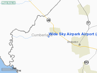
Location & QuickFacts
| FAA Information Effective: | 2008-09-25 |
| Airport Identifier: | JY31 |
| Airport Status: | Operational |
| Longitude/Latitude: | 075-18-47.6900W/39-26-48.4100N
-75.313247/39.446781 (Estimated) |
| Elevation: | 100 ft / 30.48 m (Surveyed) |
| Land: | 23 acres |
| From nearest city: | 3 nautical miles NW of Bridgeton, NJ |
| Location: | Cumberland County, NJ |
| Magnetic Variation: | 11W (1985) |
Owner & Manager
| Ownership: | Privately owned |
| Owner: | Cherokee Realty Corp. |
| Address: | 440 Front St, P.o. Box 617
Elmer, NJ 68318 |
| Phone number: | 856-358-7216 |
| Manager: | Winfield Andrews |
| Address: | 263 Shilph Rd
Bridgeton, NJ 08302 |
| Phone number: | 609-451-0424 |
Airport Operations and Facilities
| Airport Use: | Private |
| Wind indicator: | Yes |
| Segmented Circle: | No |
| Control Tower: | No |
| Lighting Schedule: | PHONE REQ
FOR LIRL RY 04/22 CALL 609-451-0424. |
| Landing fee charge: | No |
| Sectional chart: | Washington |
| Region: | AEA - Eastern |
| Traffic Pattern Alt: | 900 ft |
| Boundary ARTCC: | ZDC - Washington |
| Tie-in FSS: | MIV - Millville |
| FSS on Airport: | No |
| FSS Toll Free: | 1-800-WX-BRIEF |
Airport Services
Runway Information
Runway 04/22
| Dimension: | 2550 x 150 ft / 777.2 x 45.7 m |
| Surface: | TURF, Good Condition |
| Edge Lights: | Low |
| |
Runway 04 |
Runway 22 |
| Traffic Pattern: | Left | Left |
| Runway End Identifier: | No | No |
| Obstruction: | 66 ft trees, 550.0 ft from runway | |
|
Radio Navigation Aids
| ID |
Type |
Name |
Ch |
Freq |
Var |
Dist |
| RNB | NDB | Rainbow | | 363.00 | 11W | 8.4 nm |
| APG | NDB | Aberdeen | | 349.00 | 11W | 37.2 nm |
| ING | NDB | Ambler | | 275.00 | 11W | 40.8 nm |
| NXX | NDB | Willow Grove | | 388.00 | 12W | 45.3 nm |
| DOV | TACAN | Dover | 037X | | 09W | 20.2 nm |
| NXX | TACAN | Willow Grove | 061X | | 10W | 45.6 nm |
| PNE | VOR | North Philadelphia | | 112.00 | 10W | 40.7 nm |
| ATR | VOR/DME | Waterloo | 073X | 112.60 | 09W | 38.6 nm |
| PPM | VOR/DME | Phillips | 021X | 108.40 | 09W | 39.8 nm |
| OOD | VORTAC | Woodstown | 075X | 112.80 | 10W | 11.4 nm |
| ENO | VORTAC | Smyrna | 051X | 111.40 | 09W | 16.0 nm |
| VCN | VORTAC | Cedar Lake | 099X | 115.20 | 10W | 17.0 nm |
| DQO | VORTAC | Dupont | 087X | 114.00 | 10W | 19.5 nm |
| SIE | VORTAC | Sea Isle | 095X | 114.80 | 09W | 31.9 nm |
| MXE | VORTAC | Modena | 079X | 113.20 | 09W | 32.8 nm |
| ACY | VORTAC | Atlantic City | 023X | 108.60 | 10W | 34.2 nm |
| CYN | VORTAC | Coyle | 081X | 113.40 | 10W | 46.5 nm |
| GXU | VORTAC | Mc Guire | 043X | 110.60 | 11W | 47.4 nm |
| PTW | VORTAC | Pottstown | 112X | 116.50 | 09W | 48.0 nm |
| PHL | VOT | Philadelphia Intl | | 109.80 | | 25.7 nm |
Remarks
- ARPT MAY BE CLSD DURING FREEZING AND THAWING PERIODS DUE TO RWY CONDITIONS.
- VFR USE ONLY.
Images and information placed above are from
http://www.airport-data.com/airport/JY31/
We thank them for the data!
| General Info
|
| Country |
United States
|
| State |
NEW JERSEY
|
| FAA ID |
JY31
|
| Latitude |
39-26-48.410N
|
| Longitude |
075-18-47.690W
|
| Elevation |
100 feet
|
| Near City |
BRIDGETON
|
We don't guarantee the information is fresh and accurate. The data may
be wrong or outdated.
For more up-to-date information please refer to other sources.
|
|


