 |
|
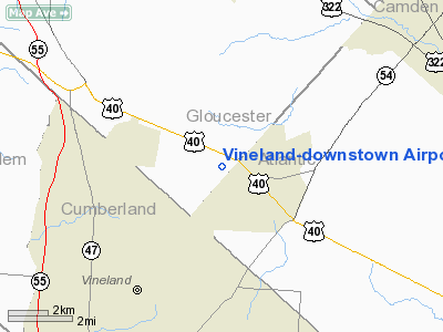
Vineland-downstown Airport |
Coordinates: 39°32′15.416″N 074°57′58.618″W / 39.53761556°N 74.96628278°W / 39.53761556; -74.96628278
| Vineland-Downstown Airport |
| IATA: none – ICAO: none – FAA LID: 28N |
| Summary |
| Airport type |
Public |
| Owner |
Downstown Arpt. Inc. |
| Operator |
Curtis Nixholm |
| Serves |
Vineland, New Jersey |
| Location |
Gloucester County, New Jersey |
| Elevation AMSL |
120 ft / 37 m |
| Runways |
| Direction |
Length |
Surface |
| ft |
m |
| 02/20 |
2,251 |
686 |
Turf |
| 12/30 |
1,800 |
549 |
Turf |
| Statistics (2009) |
| Aircraft operations |
13,700 |
| Based aircraft |
21 |
| Source: Federal Aviation Administration |
Vineland-Downstown Airport (FAA LID: 28N) is a public-use airport located four nautical miles (7.408 km) northeast of the central business district of the city of Vineland, New Jersey. The privately owned airport is located in Gloucester County, New Jersey, United States.
The above content comes from Wikipedia and is published under free licenses – click here to read more.
Location & QuickFacts
| FAA Information Effective: | 2008-09-25 |
| Airport Identifier: | 28N |
| Airport Status: | Operational |
| Longitude/Latitude: | 074-57-58.6180W/39-32-15.4160N
-74.966283/39.537616 (Estimated) |
| Elevation: | 120 ft / 36.58 m (Estimated) |
| Land: | 45 acres |
| From nearest city: | 4 nautical miles NE of Vineland, NJ |
| Location: | Gloucester County, NJ |
| Magnetic Variation: | 11W (1985) |
Owner & Manager
| Ownership: | Privately owned |
| Owner: | Downstown Arpt. Inc. |
| Address: | 339 Harding Hwy
Vineland, NJ 08360 |
| Phone number: | 856-697-3300 |
| Manager: | Curtis Nixholm |
| Address: | 339 Harding Hwy
Vineland, NJ 08360 |
| Phone number: | 856-697-3300 |
Airport Operations and Facilities
| Airport Use: | Open to public |
| Wind indicator: | Yes |
| Segmented Circle: | No |
| Control Tower: | No |
| Lighting Schedule: | PHONE REQ
LGTS BY PRIOR ARRANGEMENT CALL 856-697-3300. |
| Landing fee charge: | No |
| Sectional chart: | Washington |
| Region: | AEA - Eastern |
| Traffic Pattern Alt: | 1200 ft |
| Boundary ARTCC: | ZDC - Washington |
| Tie-in FSS: | MIV - Millville |
| FSS on Airport: | No |
| FSS Toll Free: | 1-800-WX-BRIEF |
| NOTAMs Facility: | MIV (NOTAM-d service avaliable) |
Airport Communications
| CTAF: | 122.800 |
| Unicom: | 122.800 |
Airport Services
| Fuel available: | 100LLA
FOR FUEL PHONE 856-697-3300. |
| Airframe Repair: | NONE |
| Power Plant Repair: | NONE |
| Bottled Oxygen: | NONE |
| Bulk Oxygen: | NONE |
Runway Information
Runway 02/20
| Dimension: | 2251 x 100 ft / 686.1 x 30.5 m |
| Surface: | TURF, Good Condition |
| Edge Lights: | Low |
| |
Runway 02 |
Runway 20 |
| Traffic Pattern: | Left | Left |
| Obstruction: | 35 ft tree, 400.0 ft from runway, 160 ft left of centerline, 11:1 slope to clear | 16 ft bldg, 200.0 ft from runway, 135 ft right of centerline, 12:1 slope to clear |
|
Runway 12/30
| Dimension: | 1800 x 100 ft / 548.6 x 30.5 m |
| Surface: | TURF, Good Condition |
| |
Runway 12 |
Runway 30 |
| Traffic Pattern: | Left | Left |
| Obstruction: | 18 ft trees, 110.0 ft from runway, 40 ft right of centerline, 6:1 slope to clear | 4 ft fence, 120.0 ft from runway, 30:1 slope to clear |
|
Radio Navigation Aids
| ID |
Type |
Name |
Ch |
Freq |
Var |
Dist |
| RNB | NDB | Rainbow | | 363.00 | 11W | 10.6 nm |
| ING | NDB | Ambler | | 275.00 | 11W | 38.3 nm |
| NXX | NDB | Willow Grove | | 388.00 | 12W | 40.0 nm |
| NEL | NDB | Lakehurst | | 396.00 | 13W | 42.2 nm |
| DYL | NDB | Doylestown | | 237.00 | 10W | 48.5 nm |
| DOV | TACAN | Dover | 037X | | 09W | 33.7 nm |
| NXX | TACAN | Willow Grove | 061X | | 10W | 40.4 nm |
| NEL | TACAN | Lakehurst | 055X | | 11W | 41.3 nm |
| NEL | UHF/NDB | Lakehurst | | 274.80 | 13W | 42.2 nm |
| PNE | VOR | North Philadelphia | | 112.00 | 10W | 32.8 nm |
| ARD | VOR/DME | Yardley | 019X | 108.20 | 10W | 43.1 nm |
| ATR | VOR/DME | Waterloo | 073X | 112.60 | 09W | 45.2 nm |
| OOD | VORTAC | Woodstown | 075X | 112.80 | 10W | 16.7 nm |
| ACY | VORTAC | Atlantic City | 023X | 108.60 | 10W | 18.7 nm |
| SIE | VORTAC | Sea Isle | 095X | 114.80 | 09W | 27.7 nm |
| CYN | VORTAC | Coyle | 081X | 113.40 | 10W | 29.9 nm |
| DQO | VORTAC | Dupont | 087X | 114.00 | 10W | 30.9 nm |
| ENO | VORTAC | Smyrna | 051X | 111.40 | 09W | 31.5 nm |
| GXU | VORTAC | Mc Guire | 043X | 110.60 | 11W | 33.1 nm |
| MXE | VORTAC | Modena | 079X | 113.20 | 09W | 39.8 nm |
| RBV | VORTAC | Robbinsville | 085X | 113.80 | 10W | 45.5 nm |
| PTW | VORTAC | Pottstown | 112X | 116.50 | 09W | 49.4 nm |
| PHL | VOT | Philadelphia Intl | | 109.80 | | 23.8 nm |
Remarks
- ARPT CLSD AT NIGHT TO TRANSIENTS.
- HEAVY AGRICULTURAL OPNS APR-OCT.
- RADIO CONTROLLED MODELS OPR WEST OF RY 02/20.
- RY 12/30 RESTRICTED TO AGRICULTUARAL AND FIREFIGHTING ACFT ONLY.
- ARPT IN OPERN SINCE 1945.
Images and information placed above are from
http://www.airport-data.com/airport/28N/
We thank them for the data!
| General Info
|
| Country |
United States
|
| State |
NEW JERSEY
|
| FAA ID |
28N
|
| Latitude |
39-32-15.416N
|
| Longitude |
074-57-58.618W
|
| Elevation |
120 feet
|
| Near City |
VINELAND
|
We don't guarantee the information is fresh and accurate. The data may
be wrong or outdated.
For more up-to-date information please refer to other sources.
|
|


