 |
|
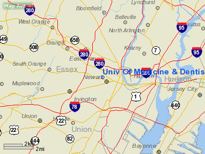
Univ Of Medicine & Dentistry Rooftop Heliport |
Location & QuickFacts
| FAA Information Effective: | 2008-09-25 |
| Airport Identifier: | NJ87 |
| Airport Status: | Operational |
| Longitude/Latitude: | 074-11-28.5220W/40-44-26.3640N
-74.191256/40.740657 (Estimated) |
| Elevation: | 237 ft / 72.24 m (Estimated) |
| Land: | 0 acres |
| From nearest city: | 0 nautical miles N of Newark, NJ |
| Location: | Essex County, NJ |
| Magnetic Variation: | 13W (1985) |
Owner & Manager
| Ownership: | Publicly owned |
| Owner: | Univ Of Medicine & Dentistry
OF NJ (UMDNJ). |
| Address: | 100 Bergen St
Newark, NJ 07103-2425 |
| Phone number: | 800-332-4356 |
| Manager: | Don Banghart |
| Address: | 150 Cabinet St
Newark, NJ 07107 |
| Phone number: | 800-332-4356 |
Airport Operations and Facilities
| Airport Use: | Private
MEDICAL USE. |
| Wind indicator: | Yes |
| Segmented Circle: | No |
| Control Tower: | No |
| Lighting Schedule: | DUSK-DAWN |
| Beacon Color: | Clear (unlighted land airport) |
| Sectional chart: | New York |
| Region: | AEA - Eastern |
| Boundary ARTCC: | ZNY - New York |
| Tie-in FSS: | MIV - Millville |
| FSS on Airport: | No |
| FSS Toll Free: | 1-800-WX-BRIEF |
Runway Information
Helipad H1
| Dimension: | 64 x 48 ft / 19.5 x 14.6 m |
| Surface: | CONC,
ROOFTOP. |
| |
Runway H1 |
Runway |
| Traffic Pattern: | Left | Left |
|
Radio Navigation Aids
| ID |
Type |
Name |
Ch |
Freq |
Var |
Dist |
| EWR | FAN MARKER | Maryann | | | 11W | 2.3 nm |
| SKU | FAN MARKER | Stanwyck | | | 12W | 47.8 nm |
| CAT | NDB | Chatham | | 254.00 | 11W | 10.9 nm |
| PNJ | NDB | Paterson | | 347.00 | 12W | 12.5 nm |
| OGY | NDB | Bridge | | 414.00 | 12W | 17.5 nm |
| BBN | NDB | Babylon | | 275.00 | 14W | 37.0 nm |
| NEL | NDB | Lakehurst | | 396.00 | 13W | 42.4 nm |
| SW | NDB | Neely | | 335.00 | 14W | 44.8 nm |
| SKU | NDB | Stanwyck | | 261.00 | 12W | 47.8 nm |
| DYL | NDB | Doylestown | | 237.00 | 10W | 49.0 nm |
| NEL | TACAN | Lakehurst | 055X | | 11W | 42.9 nm |
| NEL | UHF/NDB | Lakehurst | | 274.80 | 13W | 42.3 nm |
| TEB | VOR/DME | Teterboro | 021X | 108.40 | 11W | 8.8 nm |
| LGA | VOR/DME | La Guardia | 078X | 113.10 | 12W | 14.6 nm |
| CRI | VOR/DME | Canarsie | 070X | 112.30 | 11W | 15.6 nm |
| JFK | VOR/DME | Kennedy | 106X | 115.90 | 12W | 20.2 nm |
| COL | VOR/DME | Colts Neck | 101X | 115.40 | 11W | 25.8 nm |
| SBJ | VOR/DME | Solberg | 076X | 112.90 | 10W | 26.8 nm |
| BWZ | VOR/DME | Broadway | 089X | 114.20 | 11W | 28.9 nm |
| STW | VOR/DME | Stillwater | 033X | 109.60 | 11W | 34.4 nm |
| DPK | VOR/DME | Deer Park | 124X | 117.70 | 12W | 40.5 nm |
| CMK | VOR/DME | Carmel | 113X | 116.60 | 12W | 42.6 nm |
| ARD | VOR/DME | Yardley | 019X | 108.20 | 10W | 43.9 nm |
| HUO | VOR/DME | Huguenot | 108X | 116.10 | 11W | 44.1 nm |
| SAX | VORTAC | Sparta | 104X | 115.70 | 11W | 25.2 nm |
| RBV | VORTAC | Robbinsville | 085X | 113.80 | 10W | 35.2 nm |
| GXU | VORTAC | Mc Guire | 043X | 110.60 | 11W | 47.7 nm |
| JFK | VOT | Kennedy | | 115.10 | | 19.8 nm |
| ISP | VOT | Long Island Mac Arthur | | 109.40 | | 50.0 nm |
Remarks
- APCH FM EAST TO WEST OR FM NORTH TO SOUTH; DEP TO SOUTHWEST.
- PRVDD CTC IS MADE WITH MGR NEWARK ATCT FOR RQRD COORDINATION REGARDING TFC PATS & INST OPNS AT NEWARK INTL ARPT; IF RQRD BY NEWARK ATCT ENTER INTO A LOA WITH NEWARK ATCT STIPULATING OPERATING PROCEDURES; PILOTS OPERATING OUT OF THIS FAC ARE BRIEFED BY THE HELIPORT OPR OF OPERATING PROCEDURES.
Images and information placed above are from
http://www.airport-data.com/airport/NJ87/
We thank them for the data!
| General Info
|
| Country |
United States
|
| State |
NEW JERSEY
|
| FAA ID |
NJ87
|
| Latitude |
40-44-26.364N
|
| Longitude |
074-11-28.522W
|
| Elevation |
237 feet
|
| Near City |
NEWARK
|
We don't guarantee the information is fresh and accurate. The data may
be wrong or outdated.
For more up-to-date information please refer to other sources.
|
|


