 |
|
- For the airport in Mercer County, West Virginia, see Mercer County Airport (West Virginia).
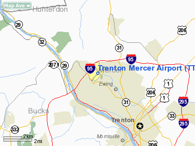
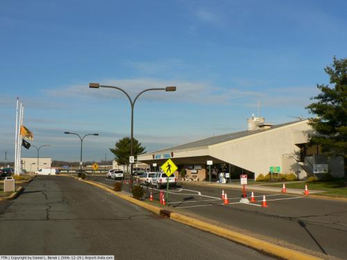
Trenton-Mercer Airport (IATA: TTN, ICAO: KTTN, FAA LID: TTN), formerly known as Mercer County Airport, is a public airport located in Ewing, New Jersey, four miles (6 km) northwest of the central business district (CBD) of Trenton, a city in Mercer County, New Jersey. The airport handles general and corporate aviation.
Trenton-Mercer is the sixth busiest airport in New Jersey overall (after Newark, Essex County, Teterboro, Morristown, and Atlantic City) and was formerly the third busiest commercially (after Newark and Atlantic City). Passenger volume, which hovered around 90,000 in the late 1990s, has fallen in the 2000s, and about 20,000 passengers traveled through the airport in 2005 according to data released by Mercer County, which owns and operates the facility. As of March 2008, all commercial passenger service to and from the airport has ceased. History
The first airplane landed at what is now Trenton-Mercer Airport in 1907, in what was then Alfred Reeder's farm field, just off of Bear Tavern Road in Ewing. Twenty-two years later in 1929, "Skillman Airport" was officially opened to the public.
During World War II, the nearby General Motors plant ceased producing civilian vehicles and began producing TBF Avenger bombers for the United States Navy. Skillman Airport was greatly expanded to accommodate test-flights of this aircraft, and after the airport was returned to county control following the end of the war, it was renamed "Mercer County Airport".
Airport Air Traffic Control operations based in the control tower were 6 AM to Midnight during the 1980s and early 1990s. Since January 1994, tower operations have been slightly shortened to 6 AM to 10 PM.
In 1995, the airport's name was officially changed from "Mercer County Airport" to "Trenton-Mercer Airport" in an effort to more closely identify it with the city of Trenton (the capital of New Jersey and county seat of Mercer County).
On March 11, 1998, an NWS/FAA Automated Surface Observing System (ASOS) became operational at the airport, replacing the human weather observers which had previously reported airport weather conditions.
For many years, the county has had plans to expand the airport and attract more commercial airlines. However, these plans have been greatly impeded due to vociferous opposition from residents of local suburban housing tracts in Ewing, Lawrence, Hopewell, Lower Makefield, Pennington and Yardley (some of which are in Pennsylvania, across the Delaware River). Most of these developments were built after the airport was first established. However, these residents see aircraft noise as detracting from their quality of life, and feel threatened by the possibility of accidents resulting from increased air traffic.
Facilities
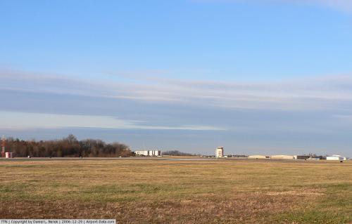
Trenton Mercer Airport covers 1,345 acres (5.44 km) and has two runways and three helipads:
- Runway 6/24: 6,006 x 150 ft (1,831 x 46 m), Surface: Asphalt
- Runway 16/34: 4,800 x 150 ft (1,463 x 46 m), Surface: Asphalt
- Helipad H1: 64 x 64 ft (20 x 20 m), Surface: Asphalt
- Helipad H2: 64 x 64 ft (20 x 20 m), Surface: Asphalt
- Helipad H3: 64 x 64 ft (20 x 20 m), Surface: Asphalt
Pilot Training
Trenton-Mercer Airport is home to multiple flight schools. Both Mercer County Community College's flight department and Airline Transport Professionals are based on the field.
The airport also is home to Royal Karina Air Service, which provides both flight training and aircraft rental.
Civil Air Patrol
Trenton-Mercer Airport is also home to the Twin Pine Composite Squadron (NER-NJ-092) of the Civil Air Patrol.
Former Commercial Service
Trenton currently has no scheduled airline service.
- In the Mid to Late 1990s Eastwind Airlines operated a hub out of Trenton to Florida and Virginia as well as airports in Massachusetts, New York and Pennsylvania. The airline flew from Philadelphia as an alternitave for a short time too. This was one of the only times Trenton-Mercer saw scheduled jet service from its short runways with 737-200 and 737-700 aircraft.
- From 1998 until 2003 Shuttle America operated a scheduled business commuter service to airports in Connecticut, Massachusetts, New York and North Carolina. The airline flew 50 seat Dash 8-311 turboprops and had all its aircraft stocked with in-flight service items when stopping in Trenton. The airline ceased operations at TTN after a codeshare service with US Airways drew customers to nearby Philadelphia from Trenton.
- In 2006 and 2007 Comair flew to both Atlanta and Boston from Trenton on behalf of Delta Connection using CRJ-200 aircraft. After a few months, Big Sky Airlines took over the Boston service flying Beech 1900 equipment. The service ended in early January 2008.
- From May 2000 until February 2008, Boston-Maine Airways operated a flight known as the Pan Am Clipper Connection between Trenton-Mercer Airport and Hanscom Field in Bedford, Massachusetts. The flight was terminated when Boston-Maine Airways ceased operating on February 28, 2008.
The above content comes from Wikipedia and is published under free licenses – click here to read more.
 |
(Click on the photo to enlarge) |
 |
(Click on the photo to enlarge) |
Location & QuickFacts
| FAA Information Effective: | 2008-09-25 |
| Airport Identifier: | TTN |
| Airport Status: | Operational |
| Longitude/Latitude: | 074-48-48.4860W/40-16-36.0880N
-74.813468/40.276691 (Estimated) |
| Elevation: | 213 ft / 64.92 m (Surveyed) |
| Land: | 1345 acres |
| From nearest city: | 4 nautical miles NW of Trenton, NJ |
| Location: | Mercer County, NJ |
| Magnetic Variation: | 12W (1985) |
Owner & Manager
| Ownership: | Publicly owned |
| Owner: | County Of Mercer |
| Address: | 640 S Broad St
Trenton, NJ 08650 |
| Phone number: | 609-989-6518 |
| Manager: | Justin P. Edwards |
| Address: | 1100 Terminal Circle Drive,ste. 301
West Trenton, NJ 08628 |
| Phone number: | 609-882-1601 |
Airport Operations and Facilities
| Airport Use: | Open to public |
| Wind indicator: | Yes |
| Segmented Circle: | No |
| Control Tower: | Yes |
| Lighting Schedule: | DUSK-DAWN
WHEN ATCT CLSD ACTVT HIRL RY 06/24; HIRL RY 16/34; MALSR RY 06; PAPI RYS 24; 16; 34; REIL RYS 24; 16; 34 & TWY LGTS - CTAF. |
| Beacon Color: | Clear-Green (lighted land airport) |
| Landing fee charge: | Yes
LDG FEE FOR ALL TRANSIENT ACFT. |
| Sectional chart: | New York |
| Region: | AEA - Eastern |
| Boundary ARTCC: | ZDC - Washington |
| Responsible ARTCC: | ZNY - New York |
| Tie-in FSS: | MIV - Millville |
| FSS on Airport: | No |
| FSS Toll Free: | 1-800-WX-BRIEF |
| NOTAMs Facility: | TTN (NOTAM-d service avaliable) |
| Certification type/date: | I A S 10/1976 |
| Federal Agreements: | NGPHY3 |
Airport Communications
| CTAF: | 120.700 |
| Unicom: | 122.950 |
Airport Services
| Fuel available: | 100LLA
FUEL AVBL ON 24/7. |
| Airframe Repair: | MAJOR |
| Power Plant Repair: | MAJOR |
| Bottled Oxygen: | LOW |
| Bulk Oxygen: | LOW |
Runway Information
Runway 06/24
| Dimension: | 6006 x 150 ft / 1830.6 x 45.7 m |
| Surface: | ASPH, Good Condition |
| Surface Treatment: | Saw-cut or plastic Grooved |
| Weight Limit: | Single wheel: 120000 lbs.
Dual wheel: 180000 lbs.
Dual tandem wheel: 320000 lbs. |
| Edge Lights: | High |
| |
Runway 06 |
Runway 24 |
| Longitude: | 074-49-17.6782W | 074-48-21.4918W |
| Latitude: | 40-16-11.1100N | 40-16-51.9810N |
| Elevation: | 160.00 ft | 192.00 ft |
| Alignment: | 46 | 127 |
| ILS Type: | ILS
| |
| Traffic Pattern: | Left | Left |
| Markings: | Precision instrument, Good Condition | Precision instrument, Good Condition |
| Crossing Height: | 0.00 ft | 39.00 ft |
| VASI: | | 4-light PAPI on left side |
| Visual Glide Angle: | 0.00° | 3.00° |
| Approach lights: | MALSR | |
| Runway End Identifier: | | Yes |
| Obstruction: | 87 ft tree, 2120.0 ft from runway, 790 ft right of centerline, 22:1 slope to clear
RWY 06, 185 FT LGTD POLE; 100 FT FROM THRESHOLD, 500 FT R. | 72 ft tree, 1610.0 ft from runway, 350 ft left of centerline, 19:1 slope to clear |
|
Runway 16/34
| Dimension: | 4800 x 150 ft / 1463.0 x 45.7 m |
| Surface: | ASPH, Good Condition |
| Surface Treatment: | Saw-cut or plastic Grooved |
| Weight Limit: | Single wheel: 120000 lbs.
Dual wheel: 180000 lbs.
Dual tandem wheel: 320000 lbs. |
| Edge Lights: | High |
| |
Runway 16 |
Runway 34 |
| Longitude: | 074-49-04.6966W | 074-48-29.7652W |
| Latitude: | 40-17-01.3748N | 40-16-22.2086N |
| Elevation: | 212.00 ft | 174.00 ft |
| Alignment: | 127 | 127 |
| Traffic Pattern: | Left | Left |
| Markings: | Non-precision instrument, Good Condition | Non-precision instrument, Good Condition |
| Crossing Height: | 40.00 ft | 50.00 ft |
| VASI: | 4-light PAPI on left side | 4-light PAPI on left side |
| Visual Glide Angle: | 3.00° | 3.00° |
| Runway End Identifier: | Yes | Yes |
| Obstruction: | , 50:1 slope to clear | 43 ft tree, 720.0 ft from runway, 300 ft left of centerline, 12:1 slope to clear |
|
Helipad H1
| Dimension: | 64 x 64 ft / 19.5 x 19.5 m |
| Surface: | ASPH, Good Condition |
| |
Runway H1 |
Runway |
| Traffic Pattern: | Left | Left |
| Markings: | Basic, Good Condition | , |
|
Helipad H2
| Dimension: | 64 x 64 ft / 19.5 x 19.5 m |
| Surface: | ASPH, Good Condition |
| |
Runway H2 |
Runway |
| Traffic Pattern: | Left | Left |
| Markings: | Basic, Good Condition | , |
|
Helipad H3
| Dimension: | 64 x 64 ft / 19.5 x 19.5 m |
| Surface: | ASPH, Good Condition |
| |
Runway H3 |
Runway |
| Traffic Pattern: | Left | Left |
| Markings: | Basic, Good Condition | , |
|
Radio Navigation Aids
| ID |
Type |
Name |
Ch |
Freq |
Var |
Dist |
| EWR | FAN MARKER | Maryann | | | 11W | 38.4 nm |
| DYL | NDB | Doylestown | | 237.00 | 10W | 14.6 nm |
| NXX | NDB | Willow Grove | | 388.00 | 12W | 16.1 nm |
| ING | NDB | Ambler | | 275.00 | 11W | 23.5 nm |
| UKT | NDB | Quakertown | | 208.00 | 12W | 23.9 nm |
| NEL | NDB | Lakehurst | | 396.00 | 13W | 26.0 nm |
| CAT | NDB | Chatham | | 254.00 | 11W | 33.0 nm |
| OGY | NDB | Bridge | | 414.00 | 12W | 46.0 nm |
| NXX | TACAN | Willow Grove | 061X | | 10W | 16.1 nm |
| NEL | TACAN | Lakehurst | 055X | | 11W | 25.6 nm |
| NEL | UHF/NDB | Lakehurst | | 274.80 | 13W | 26.0 nm |
| PNE | VOR | North Philadelphia | | 112.00 | 10W | 14.8 nm |
| ARD | VOR/DME | Yardley | 019X | 108.20 | 10W | 4.5 nm |
| SBJ | VOR/DME | Solberg | 076X | 112.90 | 10W | 18.7 nm |
| CKZ | VOR/DME | Pennridge | 025Y | 108.85 | 12W | 22.8 nm |
| COL | VOR/DME | Colts Neck | 101X | 115.40 | 11W | 30.0 nm |
| BWZ | VOR/DME | Broadway | 089X | 114.20 | 11W | 31.4 nm |
| STW | VOR/DME | Stillwater | 033X | 109.60 | 11W | 43.3 nm |
| ETX | VOR/DME | East Texas | 039X | 110.20 | 09W | 43.8 nm |
| CRI | VOR/DME | Canarsie | 070X | 112.30 | 11W | 46.6 nm |
| TEB | VOR/DME | Teterboro | 021X | 108.40 | 11W | 48.6 nm |
| RBV | VORTAC | Robbinsville | 085X | 113.80 | 10W | 15.3 nm |
| GXU | VORTAC | Mc Guire | 043X | 110.60 | 11W | 18.9 nm |
| CYN | VORTAC | Coyle | 081X | 113.40 | 10W | 32.7 nm |
| PTW | VORTAC | Pottstown | 112X | 116.50 | 09W | 34.4 nm |
| FJC | VORTAC | Allentown | 122X | 117.50 | 10W | 39.9 nm |
| OOD | VORTAC | Woodstown | 075X | 112.80 | 10W | 44.6 nm |
| MXE | VORTAC | Modena | 079X | 113.20 | 09W | 44.9 nm |
| VCN | VORTAC | Cedar Lake | 099X | 115.20 | 10W | 45.0 nm |
| SAX | VORTAC | Sparta | 104X | 115.70 | 11W | 49.2 nm |
| PHL | VOT | Philadelphia Intl | | 109.80 | | 31.5 nm |
Remarks
- GEESE & FLOCKS OF SEA GULLS & DEER ON & INVOF ARPT.
- NOISE ABATEMENT PROCS IN EFCT; DEPS OVER 12500 LBS FLY RY HEADING UNTIL 1700 FT MSL; DEPS UNDER 12500 LBS FLY RY HEADING UNTIL 1200 FT MSL.
- NO TGL OR TRAINING OPNS 2200-0700.
- RCMD ACFT DEPG NE CLIMB AS EXPEDITIOUSLY AS PSBL TO 1500 MSL TO AVOID TWIN PINES TFC PAT; & ACFT LNDG RY 24 MAINT AT LEAST 1500 MSL TIL CLEARING THE TWIN PINES TFC PAT.
Images and information placed above are from
http://www.airport-data.com/airport/TTN/
We thank them for the data!
| General Info
|
| Country |
United States
|
| State |
NEW JERSEY
|
| FAA ID |
TTN
|
| Latitude |
40-16-36.088N
|
| Longitude |
074-48-48.486W
|
| Elevation |
213 feet
|
| Near City |
TRENTON
|
We don't guarantee the information is fresh and accurate. The data may
be wrong or outdated.
For more up-to-date information please refer to other sources.
|
|


