 |
|
Coordinates: 40°01′35.404″N 074°41′33.572″W / 40.02650111°N 74.69265889°W / 40.02650111; -74.69265889
| Redwing Airport |
| IATA: none – ICAO: none – FAA LID: 2N6 |
| Summary |
| Airport type |
Public use |
| Owner |
Central Jersey R.W. Inc. |
| Operator |
George P. Dengler |
| Serves |
Jobstown, New Jersey |
| Location |
Burlington County, New Jersey |
| Elevation AMSL |
75 ft / 23 m |
| Runways |
| Direction |
Length |
Surface |
| ft |
m |
| 06/24 |
1,830 |
558 |
Turf |
| 11/29 |
1,590 |
485 |
Turf |
| Statistics (2009) |
| Aircraft operations |
6,300 |
| Based aircraft |
15 |
| Source: Federal Aviation Administration |
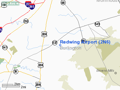
Redwing Airport (FAA LID: 2N6) is a public-use airport located one nautical mile (1.852 km) south of the central business district of the Jobstown area of Burlington County, New Jersey, United States, The airport is privately owned.
The above content comes from Wikipedia and is published under free licenses – click here to read more.
Location & QuickFacts
| FAA Information Effective: | 2008-09-25 |
| Airport Identifier: | 2N6 |
| Airport Status: | Operational |
| Longitude/Latitude: | 074-41-33.5720W/40-01-35.4040N
-74.692659/40.026501 (Estimated) |
| Elevation: | 75 ft / 22.86 m (Estimated) |
| Land: | 53 acres |
| From nearest city: | 1 nautical miles S of Jobstown, NJ |
| Location: | Burlington County, NJ |
| Magnetic Variation: | 12W (1985) |
Owner & Manager
| Ownership: | Privately owned |
| Owner: | Central Jersey R.w. Inc |
| Address: | Po Box 186 Barbara Dr.
Crosswicks, NJ 08515 |
| Phone number: | 609-298-6645 |
| Manager: | George P. Dengler |
| Address: | 46 Airport Road
Jobstown, NJ 08041 |
| Phone number: | 609-298-6645 |
Airport Operations and Facilities
| Airport Use: | Open to public |
| Wind indicator: | Yes
LIGHTED WIND TEE - UNLIGHTED WINDSOCK. |
| Segmented Circle: | No |
| Control Tower: | No |
| Landing fee charge: | No |
| Sectional chart: | New York |
| Region: | AEA - Eastern |
| Traffic Pattern Alt: | 725 ft |
| Boundary ARTCC: | ZDC - Washington |
| Responsible ARTCC: | ZNY - New York |
| Tie-in FSS: | MIV - Millville |
| FSS on Airport: | No |
| FSS Toll Free: | 1-800-WX-BRIEF |
| NOTAMs Facility: | MIV (NOTAM-d service avaliable) |
Airport Communications
Airport Services
| Airframe Repair: | MINOR |
| Power Plant Repair: | MINOR |
| Bottled Oxygen: | NONE |
| Bulk Oxygen: | NONE |
Runway Information
Runway 06/24
| Dimension: | 1830 x 50 ft / 557.8 x 15.2 m |
| Surface: | TURF, Good Condition |
| |
Runway 06 |
Runway 24 |
| Traffic Pattern: | Left | Left |
| Obstruction: | 56 ft trees, 725.0 ft from runway, 155 ft left of centerline, 12:1 slope to clear | 15 ft road, 0.0 ft from runway |
|
Runway 11/29
| Dimension: | 1590 x 70 ft / 484.6 x 21.3 m |
| Surface: | TURF, Good Condition |
| Edge Lights: | Non-standard lighting system
RWY 11/29 NSTD EDGE LIGHTS, BRIGHTNESS ADJUSTABLE LOW-HIGH. |
| |
Runway 11 |
Runway 29 |
| Traffic Pattern: | Right | Left |
| Obstruction: | 38 ft trees, 10.0 ft from runway, 100 ft left of centerline | 63 ft tree, 1500.0 ft from runway, 23:1 slope to clear |
|
Radio Navigation Aids
| ID |
Type |
Name |
Ch |
Freq |
Var |
Dist |
| EWR | FAN MARKER | Maryann | | | 11W | 46.8 nm |
| NEL | NDB | Lakehurst | | 396.00 | 13W | 16.5 nm |
| NXX | NDB | Willow Grove | | 388.00 | 12W | 23.0 nm |
| DYL | NDB | Doylestown | | 237.00 | 10W | 27.1 nm |
| ING | NDB | Ambler | | 275.00 | 11W | 27.9 nm |
| UKT | NDB | Quakertown | | 208.00 | 12W | 36.7 nm |
| RNB | NDB | Rainbow | | 363.00 | 11W | 41.9 nm |
| CAT | NDB | Chatham | | 254.00 | 11W | 44.6 nm |
| OGY | NDB | Bridge | | 414.00 | 12W | 49.4 nm |
| NEL | TACAN | Lakehurst | 055X | | 11W | 15.6 nm |
| NXX | TACAN | Willow Grove | 061X | | 10W | 23.2 nm |
| NEL | UHF/NDB | Lakehurst | | 274.80 | 13W | 16.5 nm |
| PNE | VOR | North Philadelphia | | 112.00 | 10W | 15.0 nm |
| ARD | VOR/DME | Yardley | 019X | 108.20 | 10W | 16.8 nm |
| COL | VOR/DME | Colts Neck | 101X | 115.40 | 11W | 29.9 nm |
| SBJ | VOR/DME | Solberg | 076X | 112.90 | 10W | 33.5 nm |
| CKZ | VOR/DME | Pennridge | 025Y | 108.85 | 12W | 35.1 nm |
| BWZ | VOR/DME | Broadway | 089X | 114.20 | 11W | 46.8 nm |
| GXU | VORTAC | Mc Guire | 043X | 110.60 | 11W | 4.6 nm |
| RBV | VORTAC | Robbinsville | 085X | 113.80 | 10W | 13.9 nm |
| CYN | VORTAC | Coyle | 081X | 113.40 | 10W | 17.4 nm |
| VCN | VORTAC | Cedar Lake | 099X | 115.20 | 10W | 32.0 nm |
| ACY | VORTAC | Atlantic City | 023X | 108.60 | 10W | 34.7 nm |
| OOD | VORTAC | Woodstown | 075X | 112.80 | 10W | 36.7 nm |
| PTW | VORTAC | Pottstown | 112X | 116.50 | 09W | 41.6 nm |
| MXE | VORTAC | Modena | 079X | 113.20 | 09W | 45.5 nm |
| DQO | VORTAC | Dupont | 087X | 114.00 | 10W | 47.1 nm |
| PHL | VOT | Philadelphia Intl | | 109.80 | | 27.1 nm |
Remarks
- NIGHT LANDINGS PROHIBITED DUE TO PERMANENT REDUCTION IN LENGTH OF RWY 11/29.
- NSTD LIGHTING RY 11/29 OTS INDEFLY.
- STD LEFT TFC PATTERN AT REDWING AIRPORT IS COMPATIBLE W/TFC PTN OPERATION AT PEMBERTON ARPT & MCGUIRE AFB...VFR WX CONDS.
Images and information placed above are from
http://www.airport-data.com/airport/2N6/
We thank them for the data!
| General Info
|
| Country |
United States
|
| State |
NEW JERSEY
|
| FAA ID |
2N6
|
| Latitude |
40-01-35.404N
|
| Longitude |
074-41-33.572W
|
| Elevation |
75 feet
|
| Near City |
JOBSTOWN
|
We don't guarantee the information is fresh and accurate. The data may
be wrong or outdated.
For more up-to-date information please refer to other sources.
|
|


