 |
|
Coordinates: 39°54′14.946″N 074°44′58.377″W / 39.90415167°N 74.74954917°W / 39.90415167; -74.74954917
| Red Lion Airport |
| IATA: none – ICAO: none – FAA LID: N73 |
| Summary |
| Airport type |
Public use |
| Owner |
Affiliated Air Services, Inc. |
| Operator |
Raymond P. Daniels |
| Serves |
Vincentown, New Jersey |
| Location |
Burlington County, New Jersey |
| Elevation AMSL |
54 ft / 17 m |
| Runways |
| Direction |
Length |
Surface |
| ft |
m |
| 5/23 |
2,880 |
878 |
Asphalt |
| Statistics (2008) |
| Aircraft operations |
5,920 |
| Based aircraft |
33 |
| Source: Federal Aviation Administration |
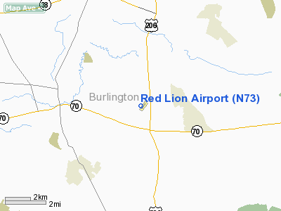
Red Lion Airport (FAA LID: N73) is a public-use airport located two nautical miles (3.704 km) south of the central business district of the Vincentown area of Southampton Township, in Burlington County, New Jersey, United States. The airport is privately owned.
The above content comes from Wikipedia and is published under free licenses – click here to read more.
Location & QuickFacts
| FAA Information Effective: | 2008-09-25 |
| Airport Identifier: | N73 |
| Airport Status: | Operational |
| Longitude/Latitude: | 074-44-58.3770W/39-54-14.9460N
-74.749549/39.904152 (Estimated) |
| Elevation: | 54 ft / 16.46 m (Surveyed) |
| Land: | 92 acres |
| From nearest city: | 2 nautical miles S of Vincentown, NJ |
| Location: | Burlington County, NJ |
| Magnetic Variation: | 10W (1965) |
Owner & Manager
| Ownership: | Privately owned |
| Owner: | Affiliated Air Services Inc |
| Address: | 235 Red Lion Rd
Southampton, NJ 08088 |
| Phone number: | 609-859-2266 |
| Manager: | Raymond P. Daniels |
| Address: | 235 Red Lion Rd
Southampton, NJ 08088 |
| Phone number: | 609-859-8544 |
Airport Operations and Facilities
| Airport Use: | Open to public |
| Wind indicator: | Yes |
| Segmented Circle: | No |
| Control Tower: | No |
| Lighting Schedule: | DUSK-DAWN
ACTVT MIRL RY 05/23 - 123.5. |
| Beacon Color: | Clear-Green (lighted land airport) |
| Landing fee charge: | No |
| Sectional chart: | Washington |
| Region: | AEA - Eastern |
| Boundary ARTCC: | ZNY - New York |
| Tie-in FSS: | MIV - Millville |
| FSS on Airport: | No |
| FSS Toll Free: | 1-800-WX-BRIEF |
| NOTAMs Facility: | MIV (NOTAM-d service avaliable) |
| Federal Agreements: | N |
Airport Communications
| CTAF: | 122.800 |
| Unicom: | 122.800 |
Airport Services
| Fuel available: | 100LL |
| Airframe Repair: | MAJOR |
| Power Plant Repair: | MAJOR |
| Bottled Oxygen: | NONE |
| Bulk Oxygen: | NONE |
Runway Information
Runway 05/23
| Dimension: | 2880 x 50 ft / 877.8 x 15.2 m |
| Surface: | ASPH, Fair Condition |
| Edge Lights: | Non-standard lighting system
RWY 05 THLD LGTS INSTALLED 110 FT BYND THLD. |
| |
Runway 05 |
Runway 23 |
| Longitude: | 074-45-09.8710W | 074-44-46.8830W |
| Latitude: | 39-54-03.8040N | 39-54-26.0880N |
| Elevation: | 54.00 ft | 43.00 ft |
| Alignment: | 38 | 127 |
| Traffic Pattern: | Left | Left |
| Markings: | Nonstandard, Good Condition
NSTD THLD MKGS, APPROX 50 FT LONG. | Nonstandard, Good Condition
NSTD THLD MKGS, APPROX 50 FT LONG. |
| Crossing Height: | 28.00 ft | 35.00 ft |
| Displaced threshold: | 0.00 ft | 140.00 ft |
| VASI: | 2-light PAPI on left side | 2-light PAPI on right side
PAPI OTS INDEFLY. |
| Visual Glide Angle: | 4.00° | 5.00° |
| Obstruction: | 58 ft trees, 225.0 ft from runway, 129 ft left of centerline
+35 FT TREE, 143 FT FM RWY END, 114 FT R. | 75 ft trees, 795.0 ft from runway, 7:1 slope to clear
12:1 BASED ON DSPLCD THLD. |
|
Radio Navigation Aids
| ID |
Type |
Name |
Ch |
Freq |
Var |
Dist |
| NEL | NDB | Lakehurst | | 396.00 | 13W | 20.9 nm |
| NXX | NDB | Willow Grove | | 388.00 | 12W | 25.0 nm |
| ING | NDB | Ambler | | 275.00 | 11W | 28.0 nm |
| DYL | NDB | Doylestown | | 237.00 | 10W | 31.1 nm |
| RNB | NDB | Rainbow | | 363.00 | 11W | 34.2 nm |
| UKT | NDB | Quakertown | | 208.00 | 12W | 40.2 nm |
| NEL | TACAN | Lakehurst | 055X | | 11W | 19.9 nm |
| NXX | TACAN | Willow Grove | 061X | | 10W | 25.3 nm |
| NEL | UHF/NDB | Lakehurst | | 274.80 | 13W | 20.9 nm |
| PNE | VOR | North Philadelphia | | 112.00 | 10W | 16.1 nm |
| ARD | VOR/DME | Yardley | 019X | 108.20 | 10W | 22.2 nm |
| COL | VOR/DME | Colts Neck | 101X | 115.40 | 11W | 36.5 nm |
| CKZ | VOR/DME | Pennridge | 025Y | 108.85 | 12W | 38.3 nm |
| SBJ | VOR/DME | Solberg | 076X | 112.90 | 10W | 40.8 nm |
| GXU | VORTAC | Mc Guire | 043X | 110.60 | 11W | 9.5 nm |
| CYN | VORTAC | Coyle | 081X | 113.40 | 10W | 15.6 nm |
| RBV | VORTAC | Robbinsville | 085X | 113.80 | 10W | 21.4 nm |
| VCN | VORTAC | Cedar Lake | 099X | 115.20 | 10W | 24.2 nm |
| ACY | VORTAC | Atlantic City | 023X | 108.60 | 10W | 28.1 nm |
| OOD | VORTAC | Woodstown | 075X | 112.80 | 10W | 30.2 nm |
| DQO | VORTAC | Dupont | 087X | 114.00 | 10W | 41.9 nm |
| PTW | VORTAC | Pottstown | 112X | 116.50 | 09W | 41.9 nm |
| MXE | VORTAC | Modena | 079X | 113.20 | 09W | 42.5 nm |
| SIE | VORTAC | Sea Isle | 095X | 114.80 | 09W | 48.7 nm |
| PHL | VOT | Philadelphia Intl | | 109.80 | | 22.9 nm |
Images and information placed above are from
http://www.airport-data.com/airport/N73/
We thank them for the data!
| General Info
|
| Country |
United States
|
| State |
NEW JERSEY
|
| FAA ID |
N73
|
| Latitude |
39-54-14.946N
|
| Longitude |
074-44-58.377W
|
| Elevation |
54 feet
|
| Near City |
VINCENTOWN
|
We don't guarantee the information is fresh and accurate. The data may
be wrong or outdated.
For more up-to-date information please refer to other sources.
|
|


