|
|
| Princeton Airport |
 |
| IATA: PCT – ICAO: none – FAA LID: 39N |
| Summary |
| Airport type |
Public use |
| Owner |
Princeton Aero Corp., Phil Cortese |
| Serves |
Princeton, New Jersey |
| Location |
Montgomery Township, New Jersey |
| Elevation AMSL |
128 ft / 39 m |
| Coordinates |
40°23′57″N 074°39′32″W / 40.39917°N 74.65889°W / 40.39917; -74.65889 |
| Website |
www.PrincetonAirport.com |
| Runways |
| Direction |
Length |
Surface |
| ft |
m |
| 10/28 |
3,500 |
1,067 |
Asphalt |
| Statistics (2005) |
| Aircraft operations |
56,958 |
| Based aircraft |
146 |
| Source: Federal Aviation Administration |
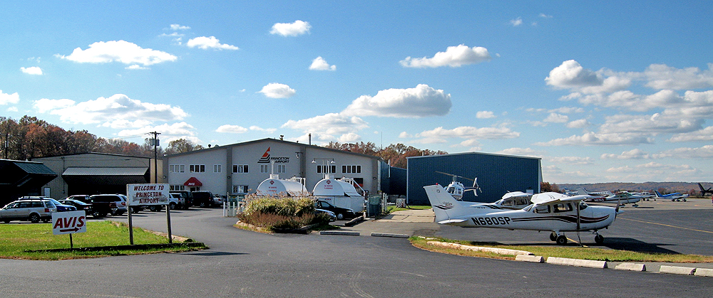
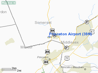
Princeton Airport (IATA: PCT, FAA LID: 39N) is a public-use airport located in Montgomery Township, Somerset County, New Jersey, United States, three miles (5 km) north of the central business district of Princeton and just west of Rocky Hill. The airport is privately owned by Princeton Aero Corp. The airport also houses the Raritan Valley Flying School, Princeton Pilot Shop, Pacific Aircraft, Analar Helicopter Charter, Air Transport Charter, and Nassau Helicopters. History
The airport was established by Richard A. Newhouse (original spelling Neuhaus). Among his other aviation-related projects, in 1911 he built a plane of his own design, featuring separate floating ailerons — a major innovation, as the planes of that time used wing warping for roll control.
On March 29, 1985, the airport was purchased by Princeton Aero Corp. Principals of the company are members of the Nierenberg family, previously the fixed base operator at Kupper Airport for eighteen years.
Facilities and aircraft
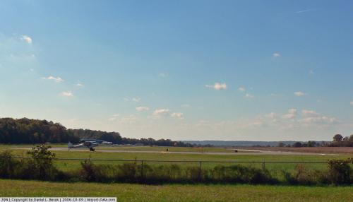
Princeton Airport covers an area of 104 acres (40 ha) which contains one paved runway (10/28) measuring 3,500 x 75 ft (1,067 x 23 m).
For the 12-month period ending January 2, 2005, the airport had 56,958 aircraft operations, an average of 156 per day: 89% general aviation and 11% air taxi. There are 148 aircraft based at this airport: 81% single engine, 11% multi-engine and 7% helicopters.
The above content comes from Wikipedia and is published under free licenses – click here to read more.
 |
(Click on the photo to enlarge) |
Location & QuickFacts
| FAA Information Effective: | 2008-09-25 |
| Airport Identifier: | 39N |
| Airport Status: | Operational |
| Longitude/Latitude: | 074-39-32.0000W/40-23-57.0000N
-74.658889/40.399167 (Estimated) |
| Elevation: | 128 ft / 39.01 m (Surveyed) |
| Land: | 100 acres |
| From nearest city: | 3 nautical miles N of Princeton/rocky Hill, NJ |
| Location: | Somerset County, NJ |
| Magnetic Variation: | 13W (2005) |
Owner & Manager
| Ownership: | Privately owned |
| Owner: | Princeton Aero Corp |
| Address: | Princeton Arpt 41 Airpark Rd
Princeton, NJ 08540 |
| Phone number: | 609-921-3100 |
| Manager: | Kenneth Nierenberg |
| Address: | Princeton Arpt 41 Airpark Rd
Princeton, NJ 08540 |
| Phone number: | 609-921-3100 |
Airport Operations and Facilities
| Airport Use: | Open to public |
| Wind indicator: | Yes |
| Segmented Circle: | No |
| Control Tower: | No |
| Lighting Schedule: | DUSK-DAWN
ACTVT MIRL RY 10/28 AND REIL RWY 10 - 123.05. |
| Beacon Color: | Clear-Green (lighted land airport) |
| Landing fee charge: | Yes |
| Sectional chart: | New York |
| Region: | AEA - Eastern |
| Traffic Pattern Alt: | 1075 ft |
| Boundary ARTCC: | ZNY - New York |
| Tie-in FSS: | MIV - Millville |
| FSS on Airport: | No |
| FSS Toll Free: | 1-800-WX-BRIEF |
| NOTAMs Facility: | MIV (NOTAM-d service avaliable) |
| Federal Agreements: | NGY |
Airport Communications
| CTAF: | 122.725 |
| Unicom: | 122.725 |
Airport Services
| Fuel available: | 100LLA |
| Airframe Repair: | MAJOR |
| Power Plant Repair: | MAJOR |
| Bottled Oxygen: | NONE |
| Bulk Oxygen: | NONE |
Runway Information
Runway 10/28
| Dimension: | 3500 x 75 ft / 1066.8 x 22.9 m |
| Surface: | ASPH, Good Condition |
| Weight Limit: | Single wheel: 15000 lbs. |
| Edge Lights: | Medium |
| |
Runway 10 |
Runway 28 |
| Longitude: | 074-39-55.0300W | 074-39-09.8000W |
| Latitude: | 40-23-56.5380N | 40-23-56.9200N |
| Elevation: | 120.00 ft | 128.00 ft |
| Alignment: | 90 | 127 |
| Traffic Pattern: | Left | Left |
| Markings: | Non-precision instrument, Good Condition | Basic, Good Condition |
| Crossing Height: | 44.00 ft | 42.00 ft |
| Displaced threshold: | 0.00 ft | 370.00 ft |
| VASI: | 2-light PAPI on left side | 2-light PAPI on left side |
| Visual Glide Angle: | 3.45° | 3.00° |
| Runway End Identifier: | Yes | |
| Obstruction: | 57 ft tree, 564.0 ft from runway, 253 ft right of centerline, 6:1 slope to clear | 55 ft tree, 480.0 ft from runway, 279 ft right of centerline, 5:1 slope to clear
RWY 28 APCH SLOPE 18:1 TO DSPLCD THR. |
|
Radio Navigation Aids
| ID |
Type |
Name |
Ch |
Freq |
Var |
Dist |
| EWR | FAN MARKER | Maryann | | | 11W | 28.2 nm |
| DYL | NDB | Doylestown | | 237.00 | 10W | 21.6 nm |
| CAT | NDB | Chatham | | 254.00 | 11W | 23.1 nm |
| NXX | NDB | Willow Grove | | 388.00 | 12W | 25.6 nm |
| NEL | NDB | Lakehurst | | 396.00 | 13W | 26.0 nm |
| UKT | NDB | Quakertown | | 208.00 | 12W | 29.3 nm |
| ING | NDB | Ambler | | 275.00 | 11W | 33.1 nm |
| OGY | NDB | Bridge | | 414.00 | 12W | 36.9 nm |
| PNJ | NDB | Paterson | | 347.00 | 12W | 40.2 nm |
| NXX | TACAN | Willow Grove | 061X | | 10W | 25.5 nm |
| NEL | TACAN | Lakehurst | 055X | | 11W | 25.9 nm |
| NEL | UHF/NDB | Lakehurst | | 274.80 | 13W | 25.9 nm |
| PNE | VOR | North Philadelphia | | 112.00 | 10W | 24.9 nm |
| SBJ | VOR/DME | Solberg | 076X | 112.90 | 10W | 11.7 nm |
| ARD | VOR/DME | Yardley | 019X | 108.20 | 10W | 14.4 nm |
| COL | VOR/DME | Colts Neck | 101X | 115.40 | 11W | 23.5 nm |
| BWZ | VOR/DME | Broadway | 089X | 114.20 | 11W | 25.1 nm |
| CKZ | VOR/DME | Pennridge | 025Y | 108.85 | 12W | 28.8 nm |
| STW | VOR/DME | Stillwater | 033X | 109.60 | 11W | 37.1 nm |
| CRI | VOR/DME | Canarsie | 070X | 112.30 | 11W | 37.2 nm |
| TEB | VOR/DME | Teterboro | 021X | 108.40 | 11W | 38.4 nm |
| LGA | VOR/DME | La Guardia | 078X | 113.10 | 12W | 42.7 nm |
| JFK | VOR/DME | Kennedy | 106X | 115.90 | 12W | 42.9 nm |
| ETX | VOR/DME | East Texas | 039X | 110.20 | 09W | 48.1 nm |
| RBV | VORTAC | Robbinsville | 085X | 113.80 | 10W | 14.0 nm |
| GXU | VORTAC | Mc Guire | 043X | 110.60 | 11W | 23.6 nm |
| CYN | VORTAC | Coyle | 081X | 113.40 | 10W | 36.5 nm |
| SAX | VORTAC | Sparta | 104X | 115.70 | 11W | 40.5 nm |
| FJC | VORTAC | Allentown | 122X | 117.50 | 10W | 41.3 nm |
| PTW | VORTAC | Pottstown | 112X | 116.50 | 09W | 42.7 nm |
| PHL | VOT | Philadelphia Intl | | 109.80 | | 41.7 nm |
| JFK | VOT | Kennedy | | 115.10 | | 42.6 nm |
Remarks
- NOISE SENSITIVE AREAS IN VICINITY OF AIRPORT. DEPARTURE NOISE ABATEMENT PROCEDURES IN EFFECT, CALL ARPT MANAGEMENT FOR INFORMATION .
- RY 10/28 NO STUDENT TOUCH AND GO FLGT ACTIVITIES.
- RWY 28 DEPARTURE NO TURNS UNTIL AT LEAST 900 FT MSL AND BEYOND CHERRY HILL RD.
- ESTAB 1927.
Images and information placed above are from
http://www.airport-data.com/airport/39N/
We thank them for the data!
| General Info
|
| Country |
United States
|
| State |
NEW JERSEY
|
| FAA ID |
39N
|
| Latitude |
40-23-57.000N
|
| Longitude |
074-39-32.000W
|
| Elevation |
125 feet
|
| Near City |
PRINCETON/ROCKY HILL
|
We don't guarantee the information is fresh and accurate. The data may
be wrong or outdated.
For more up-to-date information please refer to other sources.
|
|