 |
|
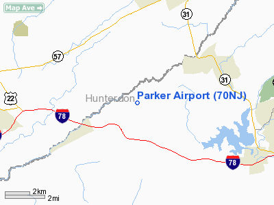
Location & QuickFacts
| FAA Information Effective: | 2008-09-25 |
| Airport Identifier: | 70NJ |
| Airport Status: | Operational |
| Longitude/Latitude: | 075-01-28.6170W/40-40-37.3610N
-75.024616/40.677045 (Estimated) |
| Elevation: | 307 ft / 93.57 m (Estimated) |
| Land: | 13 acres |
| From nearest city: | 2 nautical miles S of Asbury, NJ |
| Location: | Hunterdon County, NJ |
| Magnetic Variation: | 12W (1985) |
Owner & Manager
| Ownership: | Privately owned |
| Owner: | Warren A. Parker |
| Address: | Po Box 153, Rd 2
Asbury, NJ 08802 |
| Phone number: | 908-479-6665 |
| Manager: | Warren A. Parker |
| Address: | Po Box 153, Rd 2
Asbury, NJ 08802 |
| Phone number: | 908-479-6665 |
Airport Operations and Facilities
| Airport Use: | Private
PERSONAL USE. |
| Wind indicator: | Yes |
| Segmented Circle: | No |
| Control Tower: | No |
| Sectional chart: | New York |
| Region: | AEA - Eastern |
| Boundary ARTCC: | ZNY - New York |
| Tie-in FSS: | MIV - Millville |
| FSS Toll Free: | 1-800-WX-BRIEF |
Runway Information
Runway 07/25
| Dimension: | 1600 x 50 ft / 487.7 x 15.2 m |
| Surface: | TURF, |
| |
Runway 07 |
Runway 25 |
| Traffic Pattern: | Left | Right |
|
Radio Navigation Aids
| ID |
Type |
Name |
Ch |
Freq |
Var |
Dist |
| EWR | FAN MARKER | Maryann | | | 11W | 38.2 nm |
| UKT | NDB | Quakertown | | 208.00 | 12W | 19.6 nm |
| DYL | NDB | Doylestown | | 237.00 | 10W | 21.0 nm |
| CAT | NDB | Chatham | | 254.00 | 11W | 27.4 nm |
| NXX | NDB | Willow Grove | | 388.00 | 12W | 29.8 nm |
| LQX | NDB | Carbon | | 339.00 | 12W | 34.4 nm |
| ING | NDB | Ambler | | 275.00 | 11W | 35.2 nm |
| PNJ | NDB | Paterson | | 347.00 | 12W | 42.9 nm |
| HXM | NDB | Humbolt | | 366.00 | 10W | 48.0 nm |
| CYE | NDB | Crystal Lake | | 410.00 | 11W | 48.7 nm |
| NEL | NDB | Lakehurst | | 396.00 | 13W | 49.4 nm |
| NXX | TACAN | Willow Grove | 061X | | 10W | 29.5 nm |
| NEL | TACAN | Lakehurst | 055X | | 11W | 49.3 nm |
| NEL | UHF/NDB | Lakehurst | | 274.80 | 13W | 49.4 nm |
| PNE | VOR | North Philadelphia | | 112.00 | 10W | 35.8 nm |
| BWZ | VOR/DME | Broadway | 089X | 114.20 | 11W | 11.8 nm |
| SBJ | VOR/DME | Solberg | 076X | 112.90 | 10W | 14.1 nm |
| STW | VOR/DME | Stillwater | 033X | 109.60 | 11W | 20.4 nm |
| CKZ | VOR/DME | Pennridge | 025Y | 108.85 | 12W | 21.0 nm |
| ARD | VOR/DME | Yardley | 019X | 108.20 | 10W | 26.0 nm |
| ETX | VOR/DME | East Texas | 039X | 110.20 | 09W | 30.6 nm |
| TEB | VOR/DME | Teterboro | 021X | 108.40 | 11W | 45.0 nm |
| COL | VOR/DME | Colts Neck | 101X | 115.40 | 11W | 45.2 nm |
| HUO | VOR/DME | Huguenot | 108X | 116.10 | 11W | 48.2 nm |
| FJC | VORTAC | Allentown | 122X | 117.50 | 10W | 19.8 nm |
| SAX | VORTAC | Sparta | 104X | 115.70 | 11W | 32.2 nm |
| PTW | VORTAC | Pottstown | 112X | 116.50 | 09W | 36.7 nm |
| RBV | VORTAC | Robbinsville | 085X | 113.80 | 10W | 37.4 nm |
| GXU | VORTAC | Mc Guire | 043X | 110.60 | 11W | 44.7 nm |
| LVZ | VORTAC | Wilkes-barre | 053X | 111.60 | 10W | 46.8 nm |
| PHL | VOT | Philadelphia Intl | | 109.80 | | 49.5 nm |
Remarks
- 30' TREES 50' NORTH OF RY.
Images and information placed above are from
http://www.airport-data.com/airport/70NJ/
We thank them for the data!
| General Info
|
| Country |
United States
|
| State |
NEW JERSEY
|
| FAA ID |
70NJ
|
| Latitude |
40-40-37.361N
|
| Longitude |
075-01-28.617W
|
| Elevation |
307 feet
|
| Near City |
ASBURY
|
We don't guarantee the information is fresh and accurate. The data may
be wrong or outdated.
For more up-to-date information please refer to other sources.
|
|


