 |
|
Coordinates: 40°19′47.592″N 074°20′48.433″W / 40.32988667°N 74.34678694°W / 40.32988667; -74.34678694
| Old Bridge Airport |
| IATA: none – ICAO: none – FAA LID: 3N6 |
| Summary |
| Airport type |
Public use |
| Owner |
Madison Inc. |
| Operator |
Paul Cerniglia |
| Serves |
Old Bridge, New Jersey |
| Location |
Middlesex County, New Jersey |
| Elevation AMSL |
150 ft / 46 m |
| Runways |
| Direction |
Length |
Surface |
| ft |
m |
| 6/24 |
3,594 |
1,095 |
Asphalt |
| Statistics (2008) |
| Aircraft operations |
14,325 |
| Based aircraft |
4 |
| Source: Federal Aviation Administration |
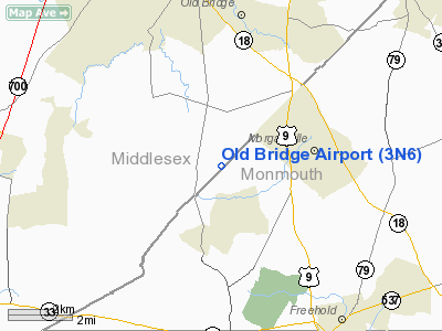
Old Bridge Airport (FAA LID: 3N6) is a public-use airport located five nautical miles (9.26 km) south of the central business district of the township of Old Bridge in Middlesex County, New Jersey, United States. The airport is privately owned. The airport is located next to Old Bridge Township Raceway Park. There is 100LL fuel on the field.
The above content comes from Wikipedia and is published under free licenses – click here to read more.
Location & QuickFacts
| FAA Information Effective: | 2008-09-25 |
| Airport Identifier: | 3N6 |
| Airport Status: | Operational |
| Longitude/Latitude: | 074-20-48.4330W/40-19-47.5920N
-74.346787/40.329887 (Estimated) |
| Elevation: | 87 ft / 26.52 m (Estimated) |
| Land: | 120 acres |
| From nearest city: | 5 nautical miles S of Old Bridge, NJ |
| Location: | Middlesex County, NJ |
| Magnetic Variation: | 10W (1965) |
Owner & Manager
| Ownership: | Privately owned |
| Owner: | Madison Inc.
DBA OLD BRIDGE A/P. |
| Address: | 182 Pension Rd
Englishtown, NJ 07726 |
| Phone number: | 732-446-0303 |
| Manager: | Paul Cerniglia |
| Address: | 182 Pension Rd
Englishtown, NJ 07726 |
| Phone number: | 732-446-0303 |
Airport Operations and Facilities
| Airport Use: | Open to public |
| Wind indicator: | Yes |
| Segmented Circle: | Yes |
| Control Tower: | No |
| Lighting Schedule: | RDO-CTL
ACTVT MIRL RY 06/24; REIL RYS 06 & 24; ROTG BCN - CTAF. |
| Beacon Color: | Clear-Green (lighted land airport) |
| Sectional chart: | New York |
| Region: | AEA - Eastern |
| Boundary ARTCC: | ZNY - New York |
| Tie-in FSS: | MIV - Millville |
| FSS on Airport: | No |
| FSS Toll Free: | 1-800-WX-BRIEF |
| NOTAMs Facility: | MIV (NOTAM-d service avaliable) |
| Federal Agreements: | N |
Airport Communications
| CTAF: | 123.075 |
| Unicom: | 123.075 |
Airport Services
| Fuel available: | 100LL |
| Airframe Repair: | MAJOR |
| Power Plant Repair: | MAJOR |
| Bottled Oxygen: | NONE |
| Bulk Oxygen: | NONE |
Runway Information
Runway 06/24
| Dimension: | 3594 x 50 ft / 1095.5 x 15.2 m |
| Surface: | ASPH, Good Condition |
| Edge Lights: | Medium |
| |
Runway 06 |
Runway 24 |
| Longitude: | 074-21-04.6200W | 074-20-32.2200W |
| Latitude: | 40-19-34.8660N | 40-20-00.2880N |
| Elevation: | 63.00 ft | 86.00 ft |
| Alignment: | 44 | 127 |
| Traffic Pattern: | Left | Right |
| Markings: | Non-precision instrument, Fair Condition | Non-precision instrument, Fair Condition |
| Crossing Height: | 25.00 ft | 40.00 ft |
| Displaced threshold: | 600.00 ft | 400.00 ft |
| VASI: | 2-light PAPI on left side | 2-light PAPI on right side |
| Visual Glide Angle: | 4.00° | 4.00° |
| Runway End Identifier: | Yes | Yes |
| Obstruction: | 80 ft tree, 280.0 ft from runway, 200 ft right of centerline, 1:1 slope to clear
RWY 06 APCH SLOPE 11:1 TO DSPLCD THR.
RWY 06 16 FT HANGAR 53 FT FM RY END 200 FT LEFT OF CNTRLN; 25 FT TREELINE 125 FT FM RY END ACROSS CNTRLN. | 40 ft tree, 400.0 ft from runway, 135 ft left of centerline, 5:1 slope to clear
RY 24 APCH SLOPE 20:1 TO DSPLCD THLD. |
|
Radio Navigation Aids
| ID |
Type |
Name |
Ch |
Freq |
Var |
Dist |
| EWR | FAN MARKER | Maryann | | | 11W | 23.6 nm |
| NEL | NDB | Lakehurst | | 396.00 | 13W | 17.1 nm |
| CAT | NDB | Chatham | | 254.00 | 11W | 25.0 nm |
| OGY | NDB | Bridge | | 414.00 | 12W | 25.6 nm |
| DYL | NDB | Doylestown | | 237.00 | 10W | 35.5 nm |
| NXX | NDB | Willow Grove | | 388.00 | 12W | 37.6 nm |
| PNJ | NDB | Paterson | | 347.00 | 12W | 38.1 nm |
| UKT | NDB | Quakertown | | 208.00 | 12W | 43.9 nm |
| ING | NDB | Ambler | | 275.00 | 11W | 44.8 nm |
| BBN | NDB | Babylon | | 275.00 | 14W | 48.6 nm |
| NEL | TACAN | Lakehurst | 055X | | 11W | 17.6 nm |
| NXX | TACAN | Willow Grove | 061X | | 10W | 37.6 nm |
| NEL | UHF/NDB | Lakehurst | | 274.80 | 13W | 17.1 nm |
| PNE | VOR | North Philadelphia | | 112.00 | 10W | 33.9 nm |
| COL | VOR/DME | Colts Neck | 101X | 115.40 | 11W | 8.6 nm |
| SBJ | VOR/DME | Solberg | 076X | 112.90 | 10W | 23.6 nm |
| ARD | VOR/DME | Yardley | 019X | 108.20 | 10W | 26.1 nm |
| CRI | VOR/DME | Canarsie | 070X | 112.30 | 11W | 26.8 nm |
| JFK | VOR/DME | Kennedy | 106X | 115.90 | 12W | 32.0 nm |
| TEB | VOR/DME | Teterboro | 021X | 108.40 | 11W | 33.8 nm |
| LGA | VOR/DME | La Guardia | 078X | 113.10 | 12W | 34.9 nm |
| BWZ | VOR/DME | Broadway | 089X | 114.20 | 11W | 35.5 nm |
| CKZ | VOR/DME | Pennridge | 025Y | 108.85 | 12W | 43.3 nm |
| STW | VOR/DME | Stillwater | 033X | 109.60 | 11W | 46.6 nm |
| RBV | VORTAC | Robbinsville | 085X | 113.80 | 10W | 10.2 nm |
| GXU | VORTAC | Mc Guire | 043X | 110.60 | 11W | 22.4 nm |
| CYN | VORTAC | Coyle | 081X | 113.40 | 10W | 31.1 nm |
| SAX | VORTAC | Sparta | 104X | 115.70 | 11W | 45.2 nm |
| JFK | VOT | Kennedy | | 115.10 | | 31.8 nm |
| PHL | VOT | Philadelphia Intl | | 109.80 | | 49.7 nm |
Remarks
- NO TOUCH & GO.
- GCO AVBL ON FREQ 121.725 THRU MIV FSS.
- TREES ALONG EAST SIDE OF RWY 06/24.
- GCO AVBL ON FREQ 121.725 THRU ISLIP FSS.
- A RIGHT TFC PAT MUST BE CONDUCTED TO RWY 24.
Images and information placed above are from
http://www.airport-data.com/airport/3N6/
We thank them for the data!
| General Info
|
| Country |
United States
|
| State |
NEW JERSEY
|
| FAA ID |
3N6
|
| Latitude |
40-19-47.592N
|
| Longitude |
074-20-48.433W
|
| Elevation |
87 feet
|
| Near City |
OLD BRIDGE
|
We don't guarantee the information is fresh and accurate. The data may
be wrong or outdated.
For more up-to-date information please refer to other sources.
|
|


