|
|
| Morristown Municipal Airport |
 |
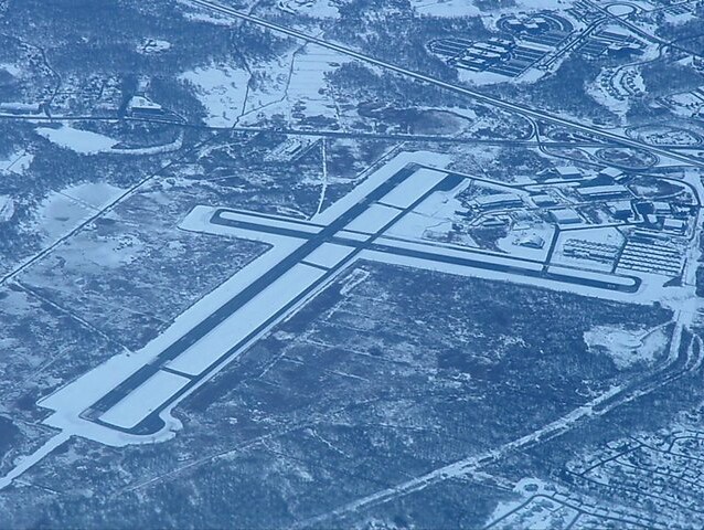
| Morristown Municipal Airport seen from a flight departing Newark |
| IATA: MMU – ICAO: KMMU – FAA LID: MMU |
| Summary |
| Airport type |
Public |
| Operator |
Town of Morristown |
| Serves |
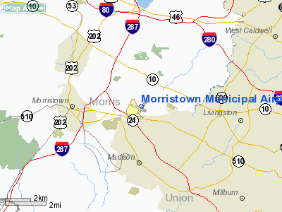
Morristown, New Jersey |
| Location |
Whippany |
| Elevation AMSL |
187 ft / 57 m |
| Coordinates |
40°47′58″N 074°24′54″W / 40.79944°N 74.415°W / 40.79944; -74.415 |
| Website |
www.mmuair.com |
| Runways |
| Direction |
Length |
Surface |
| ft |
m |
| 5/23 |
5,999 |
1,828 |
Asphalt |
| 13/31 |
3,998 |
1,219 |
Asphalt |
Morristown Municipal Airport (IATA: MMU, ICAO: KMMU, FAA LID: MMU) is a public airport located in Whippany, three miles (5 km) east of the central business district (CBD) of Morristown, in Morris County, New Jersey, USA. It is owned by the town of Morristown and operated by DM AIRPORTS, LTD Facilities
Morristown Municipal Airport covers 625 acres (253 ha) and has two runways:
- Runway 5/23: 5,999 x 150 ft (1,828 x 46 m), Surface: Asphalt-Grooved
- Runway 13/31: 3,998 x 150 ft (1,219 x 46 m), Surface: Asphalt-Grooved
FBO's
There are two FBO's on the field: Signature Flight Support FTC FBO
The above content comes from Wikipedia and is published under free licenses – click here to read more.
 |
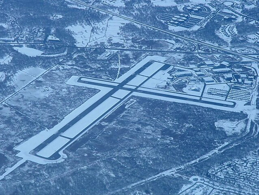
(Click on the photo to enlarge) |
Location & QuickFacts
| FAA Information Effective: | 2008-09-25 |
| Airport Identifier: | MMU |
| Airport Status: | Operational |
| Longitude/Latitude: | 074-24-53.5490W/40-47-57.6600N
-74.414875/40.799350 (Estimated) |
| Elevation: | 187 ft / 57.00 m (Surveyed) |
| Land: | 625 acres |
| From nearest city: | 3 nautical miles E of Morristown, NJ |
| Location: | Morris County, NJ |
| Magnetic Variation: | 13W (2005) |
Owner & Manager
| Ownership: | Publicly owned |
| Owner: | Town Of Morristown |
| Address: | 110 South Street
Morristown, NJ 07960 |
| Phone number: | 973-292-6626 |
| Manager: | William Barkhauer |
| Address: | D.m. Airport Developers, Inc., 8 Airport Road
Morristown, NJ 07960 |
| Phone number: | 973-538-6400 |
Airport Operations and Facilities
| Airport Use: | Open to public |
| Wind indicator: | Yes |
| Segmented Circle: | Yes |
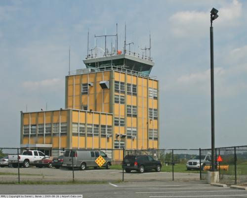
| Control Tower: | Yes |
| Lighting Schedule: | DUSK-DAWN
ACTVT HIRL RY 05/23, MIRL RY 13/31, REIL RYS 05 & 31, MALSR RY 23, & PAPI RY 31 - 118.1. |
| Beacon Color: | Clear-Green (lighted land airport) |
| Landing fee charge: | Yes |
| Sectional chart: | New York |
| Region: | AEA - Eastern |
| Boundary ARTCC: | ZNY - New York |
| Tie-in FSS: | MIV - Millville |
| FSS on Airport: | No |
| FSS Toll Free: | 1-800-WX-BRIEF |
| NOTAMs Facility: | MMU (NOTAM-d service avaliable) |
| Federal Agreements: | NGY3 |
Airport Communications
Airport Services
| Fuel available: | 100LLA |
| Airframe Repair: | MAJOR |
| Power Plant Repair: | MAJOR |
| Bottled Oxygen: | HIGH/LOW |
| Bulk Oxygen: | HIGH/LOW |
Runway Information
Runway 05/23
| Dimension: | 5999 x 150 ft / 1828.5 x 45.7 m |
| Surface: | ASPH, Good Condition |
| Surface Treatment: | Saw-cut or plastic Grooved |
| Weight Limit: | Single wheel: 30000 lbs.
Dual wheel: 80000 lbs. |
| Edge Lights: | High |
| |
Runway 05 |
Runway 23 |
| Longitude: | 074-25-09.2710W | 074-24-23.3010W |
| Latitude: | 40-47-35.1670N | 40-48-23.0520N |
| Elevation: | 182.00 ft | 184.00 ft |
| Alignment: | 36 | 127 |
| ILS Type: | | ILS
|
| Traffic Pattern: | Left | Left |
| Markings: | Precision instrument, Good Condition | Precision instrument, Good Condition |
| Approach lights: | | MALSR |
| Runway End Identifier: | Yes | |
| Obstruction: | 53 ft trees, 560.0 ft from runway, 520 ft right of centerline, 6:1 slope to clear
+6 FT BRUSH 40 FT FM RY END 335 FT R OF CNTRLN. | 37 ft tree, 220.0 ft from runway, 480 ft left of centerline
+23 FT TREES/BRUSH 25 FT FM RWY END 350 FT L CNTRLN. |
|
Runway 13/31
| Dimension: | 3998 x 150 ft / 1218.6 x 45.7 m |
| Surface: | ASPH, Good Condition |
| Surface Treatment: | Saw-cut or plastic Grooved |
| Weight Limit: | Single wheel: 30000 lbs. |
| Edge Lights: | Medium |
| |
Runway 13 |
Runway 31 |
| Longitude: | 074-25-28.3230W | 074-24-40.8080W |
| Latitude: | 40-48-03.3760N | 40-47-47.3520N |
| Elevation: | 187.00 ft | 182.00 ft |
| Alignment: | 114 | 127 |
| Traffic Pattern: | Left | Left |
| Markings: | Basic, Good Condition | Basic, Good Condition |
| Crossing Height: | 0.00 ft | 47.00 ft |
| VASI: | | 2-light PAPI on left side |
| Visual Glide Angle: | 0.00° | 3.00° |
| Runway End Identifier: | | Yes |
| Obstruction: | 41 ft trees, 320.0 ft from runway, 240 ft right of centerline, 2:1 slope to clear | 83 ft trees, 1690.0 ft from runway, 330 ft left of centerline, 17:1 slope to clear |
|
Radio Navigation Aids
| ID |
Type |
Name |
Ch |
Freq |
Var |
Dist |
| EWR | FAN MARKER | Maryann | | | 11W | 11.9 nm |
| SKU | FAN MARKER | Stanwyck | | | 12W | 46.9 nm |
| CAT | NDB | Chatham | | 254.00 | 11W | 3.6 nm |
| PNJ | NDB | Paterson | | 347.00 | 12W | 14.9 nm |
| OGY | NDB | Bridge | | 414.00 | 12W | 27.9 nm |
| SW | NDB | Neely | | 335.00 | 14W | 42.1 nm |
| DYL | NDB | Doylestown | | 237.00 | 10W | 42.7 nm |
| NEL | NDB | Lakehurst | | 396.00 | 13W | 45.5 nm |
| UKT | NDB | Quakertown | | 208.00 | 12W | 46.1 nm |
| SKU | NDB | Stanwyck | | 261.00 | 12W | 46.9 nm |
| BBN | NDB | Babylon | | 275.00 | 14W | 47.6 nm |
| NXX | NDB | Willow Grove | | 388.00 | 12W | 49.6 nm |
| NEL | TACAN | Lakehurst | 055X | | 11W | 45.9 nm |
| NXX | TACAN | Willow Grove | 061X | | 10W | 49.4 nm |
| NEL | UHF/NDB | Lakehurst | | 274.80 | 13W | 45.5 nm |
| TEB | VOR/DME | Teterboro | 021X | 108.40 | 11W | 16.3 nm |
| BWZ | VOR/DME | Broadway | 089X | 114.20 | 11W | 18.5 nm |
| SBJ | VOR/DME | Solberg | 076X | 112.90 | 10W | 19.8 nm |
| STW | VOR/DME | Stillwater | 033X | 109.60 | 11W | 23.8 nm |
| LGA | VOR/DME | La Guardia | 078X | 113.10 | 12W | 24.5 nm |
| CRI | VOR/DME | Canarsie | 070X | 112.30 | 11W | 26.2 nm |
| JFK | VOR/DME | Kennedy | 106X | 115.90 | 12W | 31.0 nm |
| COL | VOR/DME | Colts Neck | 101X | 115.40 | 11W | 31.5 nm |
| HUO | VOR/DME | Huguenot | 108X | 116.10 | 11W | 37.5 nm |
| ARD | VOR/DME | Yardley | 019X | 108.20 | 10W | 39.8 nm |
| CKZ | VOR/DME | Pennridge | 025Y | 108.85 | 12W | 46.8 nm |
| CMK | VOR/DME | Carmel | 113X | 116.60 | 12W | 47.6 nm |
| SAX | VORTAC | Sparta | 104X | 115.70 | 11W | 17.1 nm |
| RBV | VORTAC | Robbinsville | 085X | 113.80 | 10W | 36.1 nm |
| FJC | VORTAC | Allentown | 122X | 117.50 | 10W | 47.5 nm |
| GXU | VORTAC | Mc Guire | 043X | 110.60 | 11W | 48.2 nm |
| JFK | VOT | Kennedy | | 115.10 | | 30.6 nm |
Remarks
- BIRDS & DEER ON & INVOF ARPT.
- ARFF SVCS AVBL 24 HRS DAILY. FOR ARFF SVCS WHEN ATCT CLSD CTC ARFF STATION; CTAF OR 973-455-1953.
- ALL ARRIVAL/DEPARTURE ACFT FOLLOW MANUFACTURERS RECOMMENDED PROCEDURES FOR QUIET OPNS & MINIMUM NOISE.
- ROUTE 80 VISUAL APCH PREFERRED FOR RY 23.
- HELICOPTER OPNS OVER RESIDENTIAL AREAS BLO 1000 FT MSL SHOULD BE AVOIDED.
- STAGE I DEPARTURE FEE 2300-0645.
- DURG SNOW REMOVAL OPNS 15 MINUTE PRIOR NOTICE REQUIRED ON 118.1 & NO PRACTICE LOW APCHS OR TOUCH & GO LDGS.
- INBOUND TFC REQUEST FBO SVCS, INSTRUCTIONS & RAMP ADVISORIES 30 MINUTES PRIOR TO ARRIVAL. AFTER LDG CTC FBO AGAIN 129.6 FOR PREFERRED RAMP ENTRANCE TO DELTA OR ECHO TWYS.
- NOISE ABATEMENT PROC IN EFCT; CTC NOISE ABATEMENT OFC 973-538-3366 EXTN 122.
- US CUSTOMS AVBL MON-FRI 0800-1600; BTN 1601-0759 & WKENDS CALL 973-267-0302 FOR APPOINTMENT. MORRISTOWN CUSTOMS ASSOCIATION FEES APPLY; CTC AMGR 973-538-6400 FOR DETAILS.
- NO TURBOJET LNDG ON RWY 13 & 31 UNLESS THE X-WIND VELOCITY FOR RWY 5/23 EXCEEDS 16 KNOTS.
- INTO-PLANE CONTRACT FUEL 100LL; A WITH & WO ICING INHIBITOR & 0-128 AVOIL AVBL.
- ACFT CARRYING EXPLOSIVE CARGO PPR BEFORE LDG - CALL 973-538-6400.
- FLIGHT NOTIFICATION SVC (ADCUS) AVBL.
- U.S. CUSTOMS USER FEE ARPT.
Images and information placed above are from
http://www.airport-data.com/airport/MMU/
We thank them for the data!
| General Info
|
| Country |
United States
|
| State |
NEW JERSEY
|
| FAA ID |
MMU
|
| Latitude |
40-47-57.660N
|
| Longitude |
074-24-53.549W
|
| Elevation |
187 feet
|
| Near City |
MORRISTOWN
|
We don't guarantee the information is fresh and accurate. The data may
be wrong or outdated.
For more up-to-date information please refer to other sources.
|
|