|
 |
|
||||
|
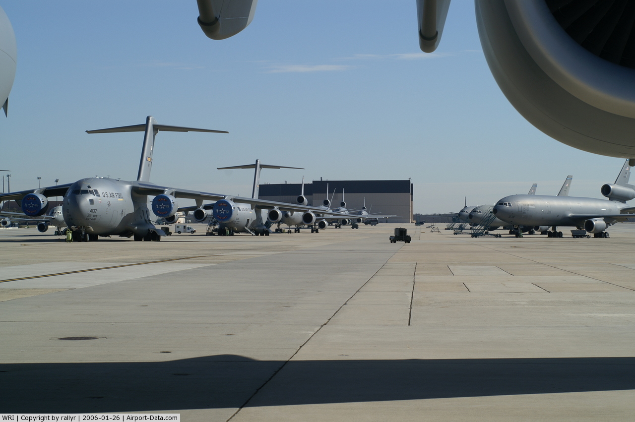
McGuire Air Force Base (AFB) (IATA: WRI, ICAO: KWRI, FAA LID: WRI) is a United States Air Force base located approximately 35 miles (56 km) east of Philadelphia, Pennsylvania. On October 1, 2009, McGuire officially became part of Joint Base McGuire-Dix-Lakehurst. Base officials refer to Joint Base McGuire-Dix-Lakehurst as "JB MDL". The host unit at McGuire AFB is the 87th Air Base Wing (87 ABW), assigned to the Air Mobility Command Eighteenth Air Force. The 87 ABW provides installation management to Joint Base McGuire-Dix-Lakehurst. The wing also provides mission-ready, expeditionary Airmen to support Unified Combatant Commanders in on-going military operations. The wing consists of more than 3,100 officers, enlisted, and civilian personnel from the Air Force, Army and Navy. McGuire AFB was established in 1937 as part of Fort Dix by the United States Army, and control was assumed by the USAAF on 3 July 1942 as Fort Dix Airport. In 1948 it was re-named in honor of Major Thomas B. McGuire, Jr. (1920–1945), who was the second highest scoring American ace during World War II. The 87th Air Base Wing is commanded by Colonel Gina M. Grosso. Its Command Chief Master Sergeant is Chief Master Sergeant Lee Wofford. OverviewMcGuire (part of Joint Base McGuire-Dix-Lakehurst) is home to the 87th Air Base Wing, 305th Air Mobility Wing (305 AMW) and the Air Force Reserve Command's 514th Air Mobility Wing (514 AMW) which comprises C-17 Globemaster III and KC-10 Extender aircraft. McGuire is also home to the 108th Air Refueling Wing (108 ARW) - an Air Mobility Command-gained unit of the New Jersey Air National Guard, flying the KC-135 Stratotanker. The 305th Air Mobility Wing served as the host wing from October 1994 to March 2009, when the newly activated 87th Air Base Wing assumed installation command. The 305th, along with the 21st Expeditionary Mobility Task Force, 108th Air Wing (ANG) , 621st Contingency Response Wing, and the 514th Air Mobility Wing (AFRES), has supported every major type of air mobility mission over the past 15 years. UnitsThe following units are assigned to McGuire Air Force Base :
McGuire the only base in both the Air Mobility Command and the entire U.S. Air Force hosting three AMC-gained flying wings of the Regular Air Force, Air Force Reserve and Air National Guard. McGuire is also host to:
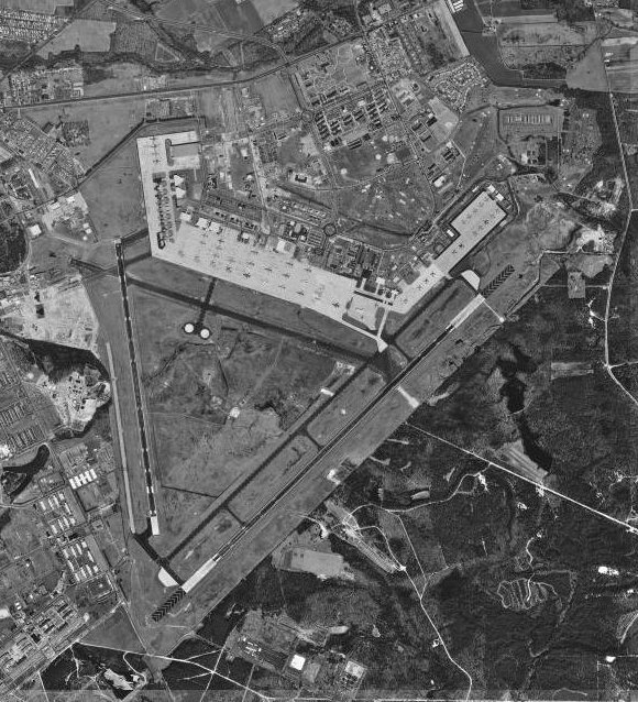
McGuire hosts the flying needs of its mission partners on Joint Base McGuire-Dix-Lakehurst. Air Force and civilian AMC-contracted aircraft use McGuire's two runways to facilitate this mission. Many hundreds of thousands of Air Force, Army, Navy, and Marine Corps personnel have left the United States for overseas locations from McGuire Air Force Base. HistoryMcGuire Air Force Base was established as Fort Dix Airport in 1937 and first opened to military aircraft on January 9, 1941. On January 13, 1948 the United States Air Force renamed the facility McGuire Air Force Base in honor of Major Thomas Buchanan McGuire, Jr, (1920–1945). Medal of Honor recipient and second place Flying ace of World War II, Major McGuire died on January 7, 1945 when his P-38 Lightning spun out of control and crashed on Los Negros Island in the South Pacific as he attempted to aid his wingman during an aerial dogfight. A precursor of the MKULTRA program began in 1945 when the Joint Intelligence Objectives Agency was established and given direct responsibility for Operation Paperclip. Operation Paperclip was a program to recruit former Nazi scientists. Some of these scientists studied torture and brainwashing, and several had just been identified and prosecuted as war criminals during the Nuremberg Trials.[9][10] Several secret U.S. government projects grew out of Operation Paperclip. These projects included Project CHATTER (established 1947), and Project BLUEBIRD (established 1950), which was renamed Project ARTICHOKE in 1951. Their purpose was to study mind-control, interrogation, behavior modification and related topics. Major commands to which assigned.* McGuire put on temporary inactive status, February 15, 1946; inactive status, March 1946; transferred to jurisdiction of Selfridge Fld, Michigan, May 1, 1947; transferred to jurisdiction of Andrews AFB, Maryland, August 1, 1947; transferred from jurisdiction of Andrews Fld to Topeka AFB, Kansas, August 16–28, 1948; reactivated as primary installation, August 29, 1948. During inactive status, field remained under major command jurisdiction. Major units assignedReferences for history introduction, major commands and major units OperationsFlight operations to support Camp Dix at an adjacent airfield took place as early as 1926. Facilities and runways to support an air mission began in 1937 as a Civilian Conservation Corps project. This was on newly acquired land for the great Army Air Forces expansion approved by the Roosevelt Administration. This nascent airfield and wooden structures was named "Rudd Field." To meet the requirements for a possible World War, Rudd Field was renamed Fort Dix Army Air Base in 1939, and underwent massive expansion from 1940–1941. This base had its first permanent Army Air Force occupant by June 1941. During 1943, the 25th Antisubmarine Wing used the airfield to fly antisubmarine patrols over the northeast coast, with B-18 Bolos covering the New York City and Boston shipping lanes. The base closed in February 1946, and for two years it remained an inactive installation until the Cold War caused the newly-created USAF to reopen many former Army Air Force installations to meet its burgeoning requirements. As the Air Force prepared to reopen by the installation as a Strategic Air Command (SAC) installation, Fort Dix AAB was renamed McGuire AFB in January 1948 in honor of USAAF Maj. Thomas B. McGuire, Jr., a World War II P-38 pilot, fighter ace, and Medal of Honor recipient, The U.S. Air Force officially reopened McGuire AFB as a primary installation August 29, 1948. While initially a combat base, operating primarily bombers and fighters of SAC and the Air Defense Command (ADC), the strategic airlift mission and the Eastern Division of the Military Air Transport Service (MATS) (later the 21st Air Force and today's 21st Expeditionary Mobility Task Force) transferred to McGuire from Westover AFB, MA, in 1954. Under MATS (later Military Airlift Command (MAC) and Air Mobility Command, McGuire became the "Gateway to the East," serving the U.S. Military and its allies in Europe, the Middle East and Africa with cargo and transportation. Over the years McGuire's mission aircraft have been: the C-54, C-118, C-135 (McGuire was the first base to operate the world's first all-jet strategic airlifter), C-130, C-141 and C-17 airlifters, as well as KC-97, KC-135 and KC-10 tanker aircraft. From 1967 through 2004, McGuire was the best-known C-141 base in the world, possessing up to a quarter of AMC's fleet of that aircraft. Team McGuire has provided support in almost every major American contingency operation from 1955 to the present, including Operation SAFE HAVEN, Vietnam, NICKEL GRASS, the Grenada rescue effort, Operation DESERT SHIELD/STORM in 1990, and Operation DESERT CALM following the first gulf war. In 1992, McGuire AFB became a major part of the newly activated AMC. A newly created concept, an air mobility wing (AMW) possessing both tankers and airlift aircraft, activated on McGuire in 1994. The storied 305th Air Refueling Wing, "Can Do!" moved to McGuire to become the host 305 AMW on October 1, 1994. The 21st Air Force, coupled with the stand up of the 621st Air Mobility Operations Group (621 AMOG) and its later reorganization to the 621st Contingency Response Wing (621 CRW), partnered with the 305 AMW and spear-headed virtually every contingency over the past 14 years, from Operation JOINT ENDEAVOR in the Balkans to Operation IRAQI FREEDOM. McGuire itself, through its support organizations, has also been a key component in the transport of materials and personnel to global crisis points. In 1999, McGuire served as the lead staging base for the evacuation of Kosovo refugees in Operation OPEN ARMS; McGuire was the rally and staging point for FEMA operations in New York City after the September 11, 2001 attacks; in 2005, the base lent key support for Hurricanes Kartrina and Rita. In 2006, McGuire AFB hosted over 1,800 Lebanese Americans evacuated from the battles there between Israel and Hezbollah insurgents. In 2008, McGuire assumed responsibility for the no-fail "Red Ball Express" aerial port mission, supplying efforts in ENDURING FREEDOM. Today the men and women of McGuire AFB continue to be in the forefront of operations, with regular deployments of airlift and aerial refueling aircraft as well as support elements for combat operations. McGuire hosted a rapidly assembled STRATCOM Joint Task Force satellite recovery team with no prior notice in February 2008, winning praise for its flexibility and support. Team McGuire remains engaged in providing direct combat support to two regional conflicts and provided personnel, resources and aircraft. Due to the Department of Defense (DoD) initiative, McGuire will be the lead service in the first tri-service Joint super-base, combining its infrastructure support with the support of Fort Dix (Army) and Naval Air Engineering Station Lakehurst (Navy). Additionally, the 2005 Base Realignment and Closure Commission (BRAC) commission identified several units to be added to Team McGuire over the next few years, including contingents from every service branch. Construction of many new facilities, a beautification effort, and new privately owned contract family housing, make McGuire one of the premier Air Force installations. Aircraft flown
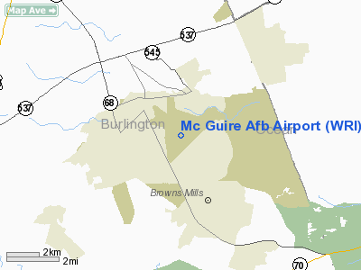
Joint basingBase Realignment and Closure is a congressionally authorized process the Department of Defense has previously used to reorganize its base structure to more efficiently support US forces, increase operational readiness and facilitate joint basing. The current process began with a threat assessment of the future national security environment, followed by the development of a force structure plan and basing requirements to meet these threats. BRAC law set into effect the Joint Base initiative which led to the establishlishment of Joint Base McGuire-Dix-Lakehurst. McGuire will receive assets and support functions from Naval Air Station Joint Reserve Base Willow Grove, which will be closed by BRAC. Under BRAC law, McGuire and Fort Dix, will host Army, Navy, Coast Guard and Marine Corps assets and will build new structures to support these additions. New support facilities will include; Navy Fleet Logistics Operations Facility, C-130 flight simulator, Marine Air Group Headquarters and helicopter hangar, Aviation Support Division/ Aviation Intermediate Maintenance division facility, munitions facility and a joint use reserve training center. Once the BRAC initiative is complete, McGuire will be home to 37 aircraft from NAS JRB Willow Grove; C-130s, C-9s, C-12s and CH-53 Super Stallions. AH-1s' UH-1 Hueys coming from Johnstown. The initiative will also bring over 1,700 joint support personnel. Under a BRAC-directed Joint Base initiative, Fort Dix and NAES Lakehurst have been combined with McGuire AFB to support the three installations as a single entity. While each installation continues to maintain its own operational identity, the consolidation will streamline installation support, while increasing mission effectiveness. Although the installation management functions have been consolidated, the missions of each of the three installations will continue. The Air Force will provide global mobility and expeditionary combat support; the Army will mobilize and train soldiers; and the Navy will continue to assure fixed and rotary wing aircraft operate safely and effectively worldwide. McGuire has a long history of providing a total force global mobility. BRAC and Joint Basing provide the opportunity to grow this into a joint capability. Of the three main armed services participating in JB MDL (Joint Base McGuire Dix Lakehurst) the Air Force and McGuire are the lead Agent. Thus, the 87th ABW is in charge of operating McGuire AFB and its commander is in charge of overseeing all aspects of JB MDL. GeographyMcGuire AFB is located at 40°2′45″N 74°35′9″W / 40.04583°N 74.58583°W (40.045969, -74.585733). According to the United States Census Bureau, the base has a total area of 5.4 km² (2.1 mi²), all land. DemographicsAs of the census of 2000, there were 6,478 people, 1,498 households, and 1,466 families residing in the base. The population density was 1,208.3/km² (3,131.0/mi²). There were 1,652 housing units at an average density of 308.1/km² (798.4/mi²). The racial makeup of the base was 69.30% White, 18.91% African American, 0.71% Native American, 2.76% Asian, 0.12% Pacific Islander, 3.18% from other races, and 5.02% from two or more races. Hispanic or Latino of any race were 8.71% of the population. There were 1,498 households out of which 79.4% had children under the age of 18 living with them, 89.0% were married couples living together, 4.9% had a female householder with no husband present, and 2.1% were non-families. 1.9% of all households were made up of individuals and none had someone living alone who was 65 years of age or older. The average household size was 3.51 and the average family size was 3.53. In the base the population was spread out with 35.6% under the age of 18, 22.8% from 18 to 24, 39.9% from 25 to 44, 1.6% from 45 to 64, and 0.1% who were 65 years of age or older. The median age was 22 years. For every 100 females there were 130.9 males. For every 100 females age 18 and over, there were 153.3 males. The median income for a household in the base was $36,347, and the median income for a family was $36,136. Males had a median income of $22,000 versus $21,659 for females. The per capita income for the base was $12,364. About 5.5% of families and 6.0% of the population were below the poverty line, including 6.7% of those under age 18 and none of those age 65 or over. Hazardous wasteIn July 2007, the United States Environmental Protection Agency issued an order to the US military to clean up the contaminants at McGuire AFB. Areas requiring cleanup include landfills, fire training areas, pesticide mixing shops, fuel storage and leak areas, underground tanks and fuel lines, a PCB (polychlorinated biphenyl) spill site, and a wastewater treatment plant sludge disposal area. [3] EducationThe North Hanover Township School District serves children in public school for grades K–6 from North Hanover Township and from McGuire Air Force Base. Schools are located on the base and in Jacobstown. The Northern Burlington County Regional School District serves children in public school for grades 7 through 12. Students are served from Chesterfield Township, Mansfield Township, North Hanover Township and Springfield Township, along with children of USAF personnel based at McGuire Air Force Base. In popular cultureIn the eighth season of the television series 24, the President and high ranking members of the United Nations are evacuated to McGuire after Manhattan is attacked by terrorists. In the early issues of the Marvel Comic book G.I. Joe: A Real American Hero, McGuire was often used by the fictional G.I. Joe team as a departure and arrival point for various missions, and storage for the teams aircraft. The above content comes from Wikipedia and is published under free licenses – click here to read more.
Location & QuickFacts
Owner & Manager
Airport Operations and Facilities
Airport Services
Runway InformationRunway 06/24
Runway 18/36
Radio Navigation Aids
Remarks
Images and information placed above are from We thank them for the data!
We don't guarantee the information is fresh and accurate. The data may
be wrong or outdated.
|
|||||||||||||||||||||||||||||||||||||||||||||||||||||||||||||||||||||||||||||||||||||||||||||||||||||||||||||||||||||||||||||||||||||||||||||||||||||||||||||||||||||||||||||||||||||||||||||||||||||||||||||||||||||||||||||||||||||||||||||||||||||||||||||||||||||||||||||||||||||||||||||||||||||||||||||||||||||||||||||||||||||||||||||||||||||||||||||||||||||||||||||||||||||||||||||||||||||||||||||||||||||||||||||||||||||||||||||||||||||||||||||||||||||||||||||||||||||||||||||||||||||||||||||||||||||||||||||||||||||||||||||

 |
|
Copyright 2004-2026 © by Airports-Worldwide.com, Vyshenskoho st. 36, Lviv 79010, Ukraine Legal Disclaimer |