 |
|
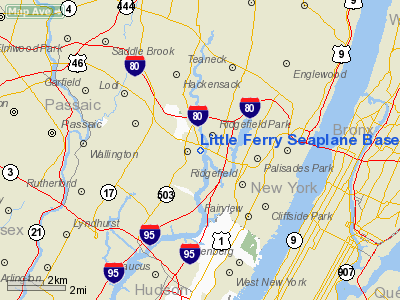
Little Ferry Seaplane Base Airport |
Coordinates: 40°50′34″N 074°01′48″W / 40.84278°N 74.03°W / 40.84278; -74.03
| Little Ferry Seaplane Base |
| IATA: none – ICAO: none – FAA LID: 2N7 |
| Summary |
| Airport type |
Public use |
| Owner |
Anastasios Georgas |
| Operator |
Anastasios Georgas |
| Serves |
Little Ferry, New Jersey |
| Location |
Bergen County, New Jersey |
| Elevation AMSL |
0 ft / 0 m |
| Runways |
| Direction |
Length |
Surface |
| ft |
m |
| 1/19 |
5,500 |
1,676 |
Water |
| Statistics (2009) |
| Aircraft operations |
5 |
| Based aircraft |
0 |
| Source: Federal Aviation Administration |
Little Ferry Seaplane Base (FAA LID: 2N7) is a public-use seaplane base located one nautical mile (1.852 km) east of the central business district of the borough of Little Ferry on the Hackensack River in Bergen County, New Jersey, United States. The base is privately owned.
The above content comes from Wikipedia and is published under free licenses – click here to read more.
Location & QuickFacts
| FAA Information Effective: | 2008-09-25 |
| Airport Identifier: | 2N7 |
| Airport Status: | Operational |
| Longitude/Latitude: | 074-01-58.5040W/40-51-00.3590N
-74.032918/40.850100 (Estimated) |
| Elevation: | 0 ft / 0.00 m (Estimated) |
| Land: | 1 acres |
| From nearest city: | 1 nautical miles E of Little Ferry, NJ |
| Location: | Bergen County, NJ |
| Magnetic Variation: | 13W (1985) |
Owner & Manager
| Ownership: | Privately owned |
| Owner: | Anastasios Georgas |
| Address: | 4 Bergen Turnpike
Little Ferry, NJ 07643 |
| Phone number: | 201-440-1100 |
| Manager: | Anastasios Georgas |
| Address: | 4 Bergen Turnpike
Little Ferry, NJ 07643 |
| Phone number: | 201-440-1100 |
Airport Operations and Facilities
| Airport Use: | Open to public |
| Wind indicator: | Yes |
| Segmented Circle: | No |
| Control Tower: | No |
| Landing fee charge: | No |
| Sectional chart: | New York |
| Region: | AEA - Eastern |
| Traffic Pattern Alt: | 500 ft |
| Boundary ARTCC: | ZNY - New York |
| Tie-in FSS: | MIV - Millville |
| FSS on Airport: | No |
| FSS Toll Free: | 1-800-WX-BRIEF |
| NOTAMs Facility: | MIV (NOTAM-d service avaliable) |
Airport Communications
| CTAF: | 122.800 |
| Unicom: | 122.800 |
Airport Services
Runway Information
Runway 01/19
| Dimension: | 5500 x 150 ft / 1676.4 x 45.7 m |
| Surface: | WATER, |
| |
Runway 01 |
Runway 19 |
| Traffic Pattern: | Left | Right |
| Obstruction: | 50 ft towers, 1000.0 ft from runway, 200 ft left of centerline, 20:1 slope to clear | 85 ft bridge-m, 1500.0 ft from runway, 17:1 slope to clear |
|
Radio Navigation Aids
| ID |
Type |
Name |
Ch |
Freq |
Var |
Dist |
| EWR | FAN MARKER | Maryann | | | 11W | 11.3 nm |
| SKU | FAN MARKER | Stanwyck | | | 12W | 40.8 nm |
| PNJ | NDB | Paterson | | 347.00 | 12W | 7.9 nm |
| OGY | NDB | Bridge | | 414.00 | 12W | 18.3 nm |
| CAT | NDB | Chatham | | 254.00 | 11W | 19.2 nm |
| BBN | NDB | Babylon | | 275.00 | 14W | 31.4 nm |
| SW | NDB | Neely | | 335.00 | 14W | 39.2 nm |
| SKU | NDB | Stanwyck | | 261.00 | 12W | 40.8 nm |
| OP | NDB | Old Field Point Light | | 316.00 | 13W | 42.2 nm |
| PO | NDB | Meier | | 403.00 | 12W | 43.7 nm |
| TEB | VOR/DME | Teterboro | 021X | 108.40 | 11W | 1.3 nm |
| LGA | VOR/DME | La Guardia | 078X | 113.10 | 12W | 8.0 nm |
| CRI | VOR/DME | Canarsie | 070X | 112.30 | 11W | 15.6 nm |
| JFK | VOR/DME | Kennedy | 106X | 115.90 | 12W | 17.7 nm |
| COL | VOR/DME | Colts Neck | 101X | 115.40 | 11W | 32.9 nm |
| CMK | VOR/DME | Carmel | 113X | 116.60 | 12W | 33.0 nm |
| DPK | VOR/DME | Deer Park | 124X | 117.70 | 12W | 33.4 nm |
| BWZ | VOR/DME | Broadway | 089X | 114.20 | 11W | 36.0 nm |
| SBJ | VOR/DME | Solberg | 076X | 112.90 | 10W | 36.1 nm |
| STW | VOR/DME | Stillwater | 033X | 109.60 | 11W | 39.0 nm |
| HUO | VOR/DME | Huguenot | 108X | 116.10 | 11W | 42.1 nm |
| BDR | VOR/DME | Bridgeport | 25X | 108.80 | 12W | 45.2 nm |
| IGN | VOR/DME | Kingston | 123X | 117.60 | 12W | 49.9 nm |
| SAX | VORTAC | Sparta | 104X | 115.70 | 11W | 26.4 nm |
| RBV | VORTAC | Robbinsville | 085X | 113.80 | 10W | 44.3 nm |
| JFK | VOT | Kennedy | | 115.10 | | 17.4 nm |
| ISP | VOT | Long Island Mac Arthur | | 109.40 | | 42.8 nm |
| BDR | VOT | Bridgeport | | 109.25 | | 45.2 nm |
Remarks
- DAYLIGHT USE ONLY.
- EXISTED PRIOR TO 1959.
Images and information placed above are from
http://www.airport-data.com/airport/2N7/
We thank them for the data!
| General Info
|
| Country |
United States
|
| State |
NEW JERSEY
|
| FAA ID |
2N7
|
| Latitude |
40-51-00.359N
|
| Longitude |
074-01-58.504W
|
| Elevation |
0 feet
|
| Near City |
LITTLE FERRY
|
We don't guarantee the information is fresh and accurate. The data may
be wrong or outdated.
For more up-to-date information please refer to other sources.
|
|


