 |
|
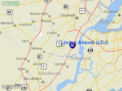
| Linden Airport |
| IATA: LDJ – ICAO: KLDJ – FAA LID: LDJ |
| Summary |
| Airport type |
Public |
| Operator |
City of Linden |
| Location |
Linden, New Jersey |
| Elevation AMSL |
23 ft / 7 m |
| Coordinates |
40°37′03″N 074°14′41″W / 40.6175°N 74.24472°W / 40.6175; -74.24472Coordinates: 40°37′03″N 074°14′41″W / 40.6175°N 74.24472°W / 40.6175; -74.24472 |
| Runways |
| Direction |
Length |
Surface |
| ft |
m |
| 9/27 |
4,137 |
1,261 |
Asphalt |
Linden Airport (IATA: LDJ, ICAO: KLDJ), also known as Linden Municipal Airport, is a small general aviation airport located along U.S. Route 1&9 in Linden, a city in Union County, New Jersey, southwest of New York City. This airport is publicly owned by the City of Linden. History
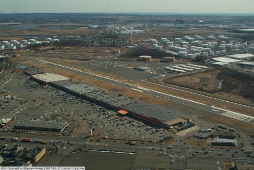
During World War II, a now closed and recently demolished General Motors factory across the street from the airport called Linden Assembly, produced military aircraft. The airport was built to allow testing and transportation of these aircraft. Since 2003, the majority of the airport has been replaced with a shopping center named Aviation Plaza. The airport retains its main building, hangars, and runway 9/27. The traffic helicopters for WABC-TV's Eyewitness News are hangared at Linden.
The airport served as a temporary road racing course in 1954 when Al Keller drove a Jaguar to victory in the then-NASCAR Grand National Division (now known as the Sprint Cup Series). It was the last win by a non-American made nameplate until Kyle Busch, driving a Toyota, won the 2007 Food City 500, spanning 53 years and nine months.
Facilities
Linden Airport covers 188 acres (76 ha) and has one runway:
- Runway 9/27: 4,137 x 100 ft. (1,261 x 30 m), Surface: Asphalt
The above content comes from Wikipedia and is published under free licenses – click here to read more.
 |
(Click on the photo to enlarge) |
Location & QuickFacts
| FAA Information Effective: | 2008-09-25 |
| Airport Identifier: | LDJ |
| Airport Status: | Operational |
| Longitude/Latitude: | 074-14-40.5390W/40-37-02.8100N
-74.244594/40.617447 (Estimated) |
| Elevation: | 23 ft / 7.01 m (Surveyed) |
| Land: | 188 acres |
| From nearest city: | 1 nautical miles SE of Linden, NJ |
| Location: | Union County, NJ |
| Magnetic Variation: | 13W (2000) |
Owner & Manager
| Ownership: | Publicly owned |
| Owner: | City Of Linden |
| Address: | Linden Airport, 1101 West Edgar Road
Linden, NJ 07036 |
| Phone number: | 908-862-5557 |
| Manager: | Paul Dudley |
| Address: | Linden Airport, 1101 West Edgar Road
Linden, NJ 07036 |
| Phone number: | 908-862-5557 |
Airport Operations and Facilities
| Airport Use: | Open to public |
| Wind indicator: | Yes |
| Segmented Circle: | Yes |
| Control Tower: | No |
| Lighting Schedule: | DUSK-DAWN
ACTVT MIRL RY 09/27; VASI RYS 09 & 27 - CTAF. |
| Beacon Color: | Clear-Green (lighted land airport) |
| Landing fee charge: | Yes |
| Sectional chart: | New York |
| Region: | AEA - Eastern |
| Traffic Pattern Alt: | 777 ft |
| Boundary ARTCC: | ZNY - New York |
| Tie-in FSS: | MIV - Millville |
| FSS on Airport: | No |
| FSS Toll Free: | 1-800-WX-BRIEF |
| NOTAMs Facility: | MIV (NOTAM-d service avaliable) |
| Federal Agreements: | NGY |
Airport Communications
| CTAF: | 123.000 |
| Unicom: | 123.000 |
Airport Services
| Fuel available: | 100LLA |
| Airframe Repair: | MINOR |
| Power Plant Repair: | MINOR |
| Bottled Oxygen: | NONE |
| Bulk Oxygen: | NONE |
Runway Information
Runway 09/27
| Dimension: | 4137 x 100 ft / 1261.0 x 30.5 m |
| Surface: | ASPH, Good Condition |
| Weight Limit: | Single wheel: 31500 lbs.
Dual wheel: 42000 lbs. |
| Edge Lights: | Medium |
| |
Runway 09 |
Runway 27 |
| Longitude: | 074-15-06.5270W | 074-14-14.5500W |
| Latitude: | 40-36-57.7490N | 40-37-07.8720N |
| Elevation: | 23.00 ft | 19.00 ft |
| Alignment: | 76 | 127 |
| Traffic Pattern: | Left | Left |
| Markings: | Basic, Good Condition | Basic, Good Condition |
| Crossing Height: | 60.00 ft | 47.00 ft |
| Displaced threshold: | 460.00 ft | 543.00 ft |
| VASI: | 4-box on right side
VASI IS BAFFLED TO CUT OFF THE LGT BEAM AT 6 DEGS EACH SIDE OF RY CNTRLN EXTDD; TOTAL USBL WIDTH IS 12 DEGS. | 4-box on left side |
| Visual Glide Angle: | 3.80° | 3.25° |
| Runway End Identifier: | Yes | Yes |
| Obstruction: | 32 ft pole, 352.0 ft from runway, 30 ft right of centerline, 4:1 slope to clear
APCH RATIO 25:1 TO DSPLCD THLD BASED ON 32 FT POLE 812 FT FM DSPLCD THLD. | 47 ft ant, 554.0 ft from runway, 100 ft right of centerline, 7:1 slope to clear
APCH RATIO23:1 TO DSPLCD THLD BASED ON 47 FT ANTENNA 1097 FT FM DSPLCD THLD. |
|
Radio Navigation Aids
| ID |
Type |
Name |
Ch |
Freq |
Var |
Dist |
| EWR | FAN MARKER | Maryann | | | 11W | 5.8 nm |
| CAT | NDB | Chatham | | 254.00 | 11W | 11.2 nm |
| OGY | NDB | Bridge | | 414.00 | 12W | 16.8 nm |
| PNJ | NDB | Paterson | | 347.00 | 12W | 20.2 nm |
| NEL | NDB | Lakehurst | | 396.00 | 13W | 34.7 nm |
| BBN | NDB | Babylon | | 275.00 | 14W | 39.4 nm |
| DYL | NDB | Doylestown | | 237.00 | 10W | 43.6 nm |
| NXX | NDB | Willow Grove | | 388.00 | 12W | 48.6 nm |
| UKT | NDB | Quakertown | | 208.00 | 12W | 49.5 nm |
| NEL | TACAN | Lakehurst | 055X | | 11W | 35.2 nm |
| NXX | TACAN | Willow Grove | 061X | | 10W | 48.5 nm |
| NEL | UHF/NDB | Lakehurst | | 274.80 | 13W | 34.7 nm |
| PNE | VOR | North Philadelphia | | 112.00 | 10W | 47.6 nm |
| CRI | VOR/DME | Canarsie | 070X | 112.30 | 11W | 16.0 nm |
| TEB | VOR/DME | Teterboro | 021X | 108.40 | 11W | 16.2 nm |
| COL | VOR/DME | Colts Neck | 101X | 115.40 | 11W | 18.8 nm |
| LGA | VOR/DME | La Guardia | 078X | 113.10 | 12W | 19.6 nm |
| JFK | VOR/DME | Kennedy | 106X | 115.90 | 12W | 21.6 nm |
| SBJ | VOR/DME | Solberg | 076X | 112.90 | 10W | 22.8 nm |
| BWZ | VOR/DME | Broadway | 089X | 114.20 | 11W | 28.5 nm |
| STW | VOR/DME | Stillwater | 033X | 109.60 | 11W | 36.4 nm |
| ARD | VOR/DME | Yardley | 019X | 108.20 | 10W | 37.4 nm |
| DPK | VOR/DME | Deer Park | 124X | 117.70 | 12W | 44.1 nm |
| CKZ | VOR/DME | Pennridge | 025Y | 108.85 | 12W | 49.6 nm |
| CMK | VOR/DME | Carmel | 113X | 116.60 | 12W | 49.9 nm |
| RBV | VORTAC | Robbinsville | 085X | 113.80 | 10W | 27.5 nm |
| SAX | VORTAC | Sparta | 104X | 115.70 | 11W | 30.2 nm |
| GXU | VORTAC | Mc Guire | 043X | 110.60 | 11W | 39.9 nm |
| CYN | VORTAC | Coyle | 081X | 113.40 | 10W | 48.9 nm |
| JFK | VOT | Kennedy | | 115.10 | | 21.3 nm |
Remarks
- TPA 800 FT MSL; RY 9 ENTER TFC PAT UPWIND - ENTRIES OTR RYS STD.
- DEPG RWY 27 DEP STRAIGHT OUT TO 800 FT.
- NOISE ABATEMENT PROCEDURES IN EFFECT.
- BIRDS ON & INVOF ARPT.
- TOUCH & GO LANDINGS FOR BASE ASSIGNED ACFT; ALL OTHERS CTC AMGR (908) 862-8800 FOR PPR.
- BANNER TOWING OPNS NORTH OF RY ON GRASS PRIMARILY SUMMER.
- RWY 09/27 RWY SHOULDER MARKINGS NSTD.
Images and information placed above are from
http://www.airport-data.com/airport/LDJ/
We thank them for the data!
| General Info
|
| Country |
United States
|
| State |
NEW JERSEY
|
| FAA ID |
LDJ
|
| Latitude |
40-37-02.810N
|
| Longitude |
074-14-40.539W
|
| Elevation |
23 feet
|
| Near City |
LINDEN
|
We don't guarantee the information is fresh and accurate. The data may
be wrong or outdated.
For more up-to-date information please refer to other sources.
|
|


