|
 |
|
||||
|
Marker Showing Disaster Landing Point
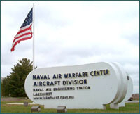
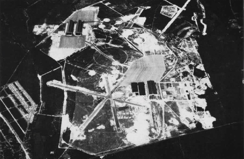
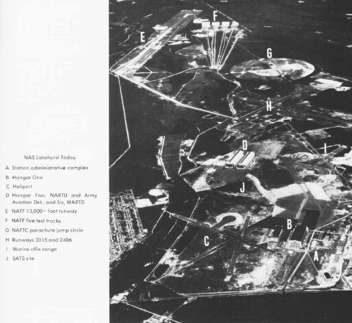
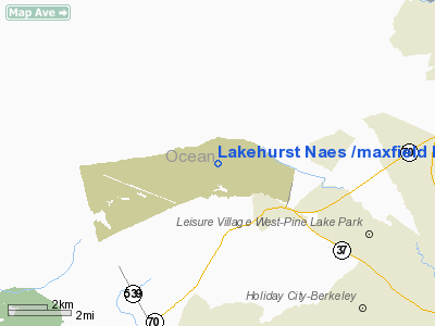
Naval Air Engineering Station Lakehurst or NAES Lakehurst (IATA: NEL, ICAO: KNEL, FAA LID: NEL), also known as Maxfield Field, is a military airport located three miles (5 km) west of the central business district (CBD) of Lakehurst, in Ocean County, New Jersey, USA. It was formerly Naval Air Station Lakehurst, and later Naval Air Engineering Center Lakehurst. Despite the name, the main gate is actually located in nearby Manchester Township, and the majority of the base in Jackson Township. On October 1, 2009, Lakehurst officially became part of Joint Base McGuire-Dix-Lakehurst. Base officials refer to Joint Base McGuire-Dix-Lakehurst as "JB MDL" HistoryIt is most famous as the site of the Hindenburg disaster on May 6, 1937. Despite the notoriety and well documented nature of this incident, today there is a simple memorial that denotes the location of the crash in the field behind the large hangars on base. Also, a ground marker locates where the gondola of the ship hit the ground, it is painted black, and rimmed by a bright yellow painted chain. Prior to this event, the base was also the center of airship development in the United States and housed three of the Navy's four rigid airships, (ZR-1) Shenandoah, (ZR-3) Los Angeles, and (ZRS-4) Akron. A number of the airship hangars built to berth these ships still survive. Hangar One, in which the Shenandoah was built, held the record for the largest "single room" in the world. According to an article in the January, 1925 issue of National Geographic Magazine, the airship hangar "could house three Woolworth Buildings lying side by side." The base housed many Navy blimps in several squadrons before, during, and after WWII. This included the U.S. Navy's ZPG-3W (EZ-1C), which was deactivated in September 1962 . In 2006, after a 44 year hiatus, the U.S. Navy resumed airship operations at Lakehurst with the MZ-3A. The former NAS Lakehurst also hosted the U.S. Navy's first helicopter squadrons; "A" and "C" enlisted training schools for the Aerographer's Mate (AG), Aviation Boatswain Mate (AB, ABE, ABF, ABH), and Parachute Rigger / Aircrew Survival Equipmentman (PR) ratings until their transfer to other Naval Air Technical Training Centers; and an Overhaul & Repair (O&R) facility for fixed-wing aircraft, the forerunner of the former Naval Air Rework Facilities and Naval Aviation Depots (NADEPs) now known as Fleet Readiness Centers (FRCs). Today the base is used for various Naval Aviation development programs. Naval Air Engineering Station Lakehurst an activity of the Naval Air Systems Command (NAVAIRSYSCOM) and is part of the Navy Lakehurst / Fort Dix / McGuire AFB Complex. MissionNaval Air Engineering Station (NAES) Lakehurst (also known as NAVAIR Lakehurst and/or Navy Lakehurst), is the northeast's largest naval aviation installation and home to the Naval Air Warfare Center Aircraft Division, as well as fourteen joint and interagency commands. NAVAIR at NAES Lakehurst is the world leader in Aircraft Launch and Recovery Equipment (ALRE) and Support Equipment (SE). Our mission, the Aircraft Platform Interface (API), assures that fixed and vertical wing aircraft operate safely and effectively from aircraft carriers, air capable ships and expeditionary airfields worldwide. With a rich heritage as the nation's lighter-than-air center, Navy Lakehurst is now the DoD's Aircraft Platform Interface expert. Lakehurst is the world's only provider of full spectrum support for aircraft launch, recovery and support equipment systems for U.S. and Allied Naval Aviation Forces at sea and Marine Corps Expeditionary Aviation Forces ashore. Lakehurst provides these services 24 hours a day, 7 days a week, both from the homebase in New Jersey as well as aboard US Navy deployed ships and Marine Expeditionary Forces. From system development, prototyping and manufacturing, testing, training, and in-service engineering, NAES Lakehurst provides the US Navy and Marine Corps aviation forces with "one-stop shopping" for all their Aircraft Platform Interface (API) needs. When it comes to deployed Navy and Marine Corps aviation, the NAES Lakehurst motto says it all: "Without Us, They Don't Go and They Can't Get Back". NAES Lakehurst is also a joint training and operations base. Host to tenant organizations from Ocean County, the state of New Jersey, the United States Army, United States Air Force, Army National Guard, Air National Guard, United States Navy Reserve, United States Public Health Service and the United States Department of Justice, NAES Lakehurst provides unparalleled mission capability for its tenants while making innovative use of tenant reimbursements to buy down the total installation infrastructure cost to the Department of Defense and the U.S. Taxpayer. Finally, NAES Lakehurst is part of a unique, three base "Mega-Base" complex with the Army's Fort Dix and the Air Force's McGuire AFB. All told, the unique contiguous arrangement of these three bases provides resident organizations with over 42,000 acres (170 km) of unique capabilities to meet their mission needs, while surrounded by 58,000 acres (230 km) of state and federally managed land to protect against encroachment. As such, coupled with its "Heritage of Service", NAES Lakehurst truly represents a "Model for the Future." Chronology
In 2005, the United States Department of Defense announced that Naval Air Engineering Station Lakehurst would be affected by a Base Realignment and Closure. It will be merged with two neighboring military bases, McGuire Air Force Base and Fort Dix, establishing Joint Base McGuire-Dix-Lakehurst, New Jersey. This will be the first base of its kind in the United States. The above content comes from Wikipedia and is published under free licenses – click here to read more.
Location & QuickFacts
Owner & Manager
Airport Operations and Facilities
Airport Services
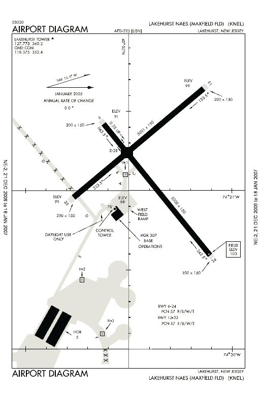
Runway InformationRunway 06/24
Runway 15/33
Radio Navigation Aids
Remarks
Images and information placed above are from We thank them for the data!
We don't guarantee the information is fresh and accurate. The data may
be wrong or outdated.
|
||||||||||||||||||||||||||||||||||||||||||||||||||||||||||||||||||||||||||||||||||||||||||||||||||||||||||||||||||||||||||||||||||||||||||||||||||||||||||||||||||||||||||||||||||||||||||||||||||||||||||||||||||||||||||||||||||||||||||||||||||||||||||||||||||||||||||||||||||||||||||||||||||||||||||||||||||||||||||||||||||||||||||||||||||||||||||||||||||||||||||||||||||||||||||||||||||||||||||||||||||||||||||||||||||||||||

 |
|
Copyright 2004-2026 © by Airports-Worldwide.com, Vyshenskoho st. 36, Lviv 79010, Ukraine Legal Disclaimer |