 |
|
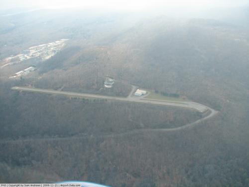 |
(Click on the photo to enlarge) |
Location & QuickFacts
| FAA Information Effective: | 2008-09-25 |
| Airport Identifier: | JY43 |
| Airport Status: | Operational |
| Longitude/Latitude: | 074-20-18.8000W/41-04-59.6000N
-74.338556/41.083222 (Estimated) |
| Elevation: | 921 ft / 280.72 m (Estimated) |
| Land: | 0 acres |
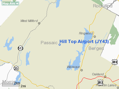
| From nearest city: | 3 nautical miles N of West Milford, NJ |
| Location: | Passaic County, NJ |
| Magnetic Variation: | () |
Owner & Manager
| Ownership: | Privately owned |
| Owner: | John E. & John P. Joseph |
| Address: | 695 Westbrook Road
Ringwood, NJ 07456 |
| Phone number: | 973-835-2394 |
| Manager: | John E. Joseph, Sr |
| Address: | 711 Westbrook Road
West Milford, NJ 07480 |
| Phone number: | 973-248-6401 |
Airport Operations and Facilities
| Airport Use: | Private |
| Wind indicator: | Yes |
| Control Tower: | No |
| Lighting Schedule: | RDO-CTL
ACTVT LIRL RY 09/27 - 123.5 |
| Sectional chart: | New York |
| Region: | AEA - Eastern |
| Boundary ARTCC: | ZNY - New York |
| Tie-in FSS: | MIV - Millville |
| FSS Toll Free: | 1-800-WX-BRIEF |
Runway Information
Runway 09/27
| Dimension: | 2150 x 40 ft / 655.3 x 12.2 m |
| Surface: | ASPH, |
| Edge Lights: | Low
LANDING TO THE WEST THE FIRST ONE-HALF OF THE LIGHTS ARE WHITE AND THE LAST ONE-HALF OF THE LIGHTS ARE AMBER. LANDING TO THE EAST ALL THE LIGHTS ARE RED. |
| |
Runway 09 |
Runway 27 |
| Traffic Pattern: | Left | Left |
| Crossing Height: | 0.00 ft | 35.00 ft |
| VASI: |
NSTD VASI - ONE BOX ON L SIDE OF RY AND ONE BOX R SIDE RY. | nonstandard system |
|
Radio Navigation Aids
| ID |
Type |
Name |
Ch |
Freq |
Var |
Dist |
| EWR | FAN MARKER | Maryann | | | 11W | 23.9 nm |
| SKU | FAN MARKER | Stanwyck | | | 12W | 29.8 nm |
| PNJ | NDB | Paterson | | 347.00 | 12W | 11.8 nm |
| CAT | NDB | Chatham | | 254.00 | 11W | 21.0 nm |
| SW | NDB | Neely | | 335.00 | 14W | 24.7 nm |
| SKU | NDB | Stanwyck | | 261.00 | 12W | 29.8 nm |
| PO | NDB | Meier | | 403.00 | 12W | 34.0 nm |
| OGY | NDB | Bridge | | 414.00 | 12W | 37.3 nm |
| MS | NDB | Monga | | 359.00 | 12W | 47.3 nm |
| BBN | NDB | Babylon | | 275.00 | 14W | 49.9 nm |
| TEB | VOR/DME | Teterboro | 021X | 108.40 | 11W | 18.9 nm |
| HUO | VOR/DME | Huguenot | 108X | 116.10 | 11W | 22.7 nm |
| STW | VOR/DME | Stillwater | 033X | 109.60 | 11W | 24.6 nm |
| LGA | VOR/DME | La Guardia | 078X | 113.10 | 12W | 27.5 nm |
| BWZ | VOR/DME | Broadway | 089X | 114.20 | 11W | 27.8 nm |
| CRI | VOR/DME | Canarsie | 070X | 112.30 | 11W | 34.8 nm |
| SBJ | VOR/DME | Solberg | 076X | 112.90 | 10W | 35.2 nm |
| CMK | VOR/DME | Carmel | 113X | 116.60 | 12W | 36.2 nm |
| JFK | VOR/DME | Kennedy | 106X | 115.90 | 12W | 37.4 nm |
| IGN | VOR/DME | Kingston | 123X | 117.60 | 12W | 42.0 nm |
| COL | VOR/DME | Colts Neck | 101X | 115.40 | 11W | 47.1 nm |
| SAX | VORTAC | Sparta | 104X | 115.70 | 11W | 9.1 nm |
| JFK | VOT | Kennedy | | 115.10 | | 37.1 nm |
Remarks
- TKOF TO THE EAST ONLY AND LAND TO THE WEST ONLY.
- PRVDD VFR OPN/PVT USE.
Images and information placed above are from
http://www.airport-data.com/airport/JY43/
We thank them for the data!
|
|


