 |
|
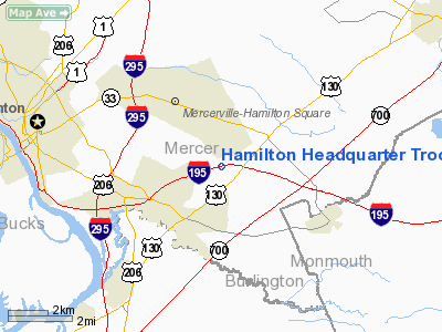
Hamilton Headquarter Troop C Heliport |
Location & QuickFacts
| FAA Information Effective: | 2008-09-25 |
| Airport Identifier: | 1JY4 |
| Airport Status: | Operational |
| Longitude/Latitude: | 074-38-54.0000W/40-12-08.0000N
-74.648333/40.202222 (Estimated) |
| Elevation: | 81 ft / 24.69 m (Estimated) |
| Land: | 1 acres |
| From nearest city: | 4 nautical miles E of Trenton, NJ |
| Location: | Mercer County, NJ |
| Magnetic Variation: | () |
Owner & Manager
| Ownership: | Publicly owned |
| Owner: | New Jersey State Police |
| Address: | P. O. Box 7068
W. Trenton, NJ 08628 |
| Phone number: | 609-880-2000 |
| Manager: | N.j. State Police Aviation Unit |
| Address: | P. O. Box 7068
W. Trenton, NJ 08628 |
| Phone number: | 609-882-3820 |
Airport Operations and Facilities
| Airport Use: | Private |
| Wind indicator: | Yes |
| Control Tower: | No |
| Lighting Schedule: | PHONE REQ
FFOR PERIMETER LGTS CALL 609-882-3820. |
| Sectional chart: | Washington |
| Region: | AEA - Eastern |
| Boundary ARTCC: | ZNY - New York |
| Tie-in FSS: | MIV - Millville |
| FSS Toll Free: | 1-800-WX-BRIEF |
Runway Information
Helipad H1
| Dimension: | 55 x 55 ft / 16.8 x 16.8 m |
| Surface: | CONC, |
| |
Runway H1 |
Runway |
| Traffic Pattern: | Left | Left |
| Markings: | Basic, Good Condition | , |
|
Radio Navigation Aids
| ID |
Type |
Name |
Ch |
Freq |
Var |
Dist |
| EWR | FAN MARKER | Maryann | | | 11W | 36.8 nm |
| NEL | NDB | Lakehurst | | 396.00 | 13W | 17.2 nm |
| NXX | NDB | Willow Grove | | 388.00 | 12W | 22.8 nm |
| DYL | NDB | Doylestown | | 237.00 | 10W | 23.2 nm |
| ING | NDB | Ambler | | 275.00 | 11W | 29.6 nm |
| UKT | NDB | Quakertown | | 208.00 | 12W | 32.6 nm |
| CAT | NDB | Chatham | | 254.00 | 11W | 33.9 nm |
| OGY | NDB | Bridge | | 414.00 | 12W | 41.4 nm |
| NEL | TACAN | Lakehurst | 055X | | 11W | 16.8 nm |
| NXX | TACAN | Willow Grove | 061X | | 10W | 22.9 nm |
| NEL | UHF/NDB | Lakehurst | | 274.80 | 13W | 17.2 nm |
| PNE | VOR | North Philadelphia | | 112.00 | 10W | 18.1 nm |
| ARD | VOR/DME | Yardley | 019X | 108.20 | 10W | 12.3 nm |
| SBJ | VOR/DME | Solberg | 076X | 112.90 | 10W | 23.3 nm |
| COL | VOR/DME | Colts Neck | 101X | 115.40 | 11W | 23.4 nm |
| CKZ | VOR/DME | Pennridge | 025Y | 108.85 | 12W | 31.5 nm |
| BWZ | VOR/DME | Broadway | 089X | 114.20 | 11W | 36.7 nm |
| CRI | VOR/DME | Canarsie | 070X | 112.30 | 11W | 42.4 nm |
| TEB | VOR/DME | Teterboro | 021X | 108.40 | 11W | 47.2 nm |
| JFK | VOR/DME | Kennedy | 106X | 115.90 | 12W | 47.8 nm |
| STW | VOR/DME | Stillwater | 033X | 109.60 | 11W | 48.8 nm |
| LGA | VOR/DME | La Guardia | 078X | 113.10 | 12W | 49.8 nm |
| RBV | VORTAC | Robbinsville | 085X | 113.80 | 10W | 7.0 nm |
| GXU | VORTAC | Mc Guire | 043X | 110.60 | 11W | 11.8 nm |
| CYN | VORTAC | Coyle | 081X | 113.40 | 10W | 25.2 nm |
| PTW | VORTAC | Pottstown | 112X | 116.50 | 09W | 41.9 nm |
| VCN | VORTAC | Cedar Lake | 099X | 115.20 | 10W | 42.6 nm |
| ACY | VORTAC | Atlantic City | 023X | 108.60 | 10W | 45.0 nm |
| OOD | VORTAC | Woodstown | 075X | 112.80 | 10W | 45.5 nm |
| FJC | VORTAC | Allentown | 122X | 117.50 | 10W | 48.5 nm |
| PHL | VOT | Philadelphia Intl | | 109.80 | | 33.9 nm |
| JFK | VOT | Kennedy | | 115.10 | | 47.5 nm |
Images and information placed above are from
http://www.airport-data.com/airport/1JY4/
We thank them for the data!
|
|


