|
|
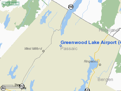
| Greenwood Lake Airport |
 |
| IATA: none – ICAO: none – FAA LID: 4N1 |
| Summary |
| Airport type |
Public |
| Operator |
New Jersey Department of Transportation |
| Location |
West Milford, New Jersey |
| Elevation AMSL |
791 ft / 241 m |
| Coordinates |
41°07′42″N 074°20′48″W / 41.12833°N 74.34667°W / 41.12833; -74.34667Coordinates: 41°07′42″N 074°20′48″W / 41.12833°N 74.34667°W / 41.12833; -74.34667 |
| Runways |
| Direction |
Length |
Surface |
| ft |
m |
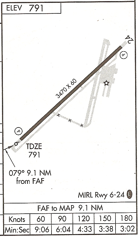
| 6/24 |
3,470 |
1,058 |
Asphalt |
| Statistics (2008) |
| Aircraft operations |
16,270 |
| Based aircraft |
63 |
| Source: Federal Aviation Administration |
Greenwood Lake Airport (FAA LID: 4N1) is a general aviation airport in West Milford, Passaic County, New Jersey, United States. This public-use airport is owned by the New Jersey Department of Transportation. It covers an area of 150 acres (61 ha) and has one runway.
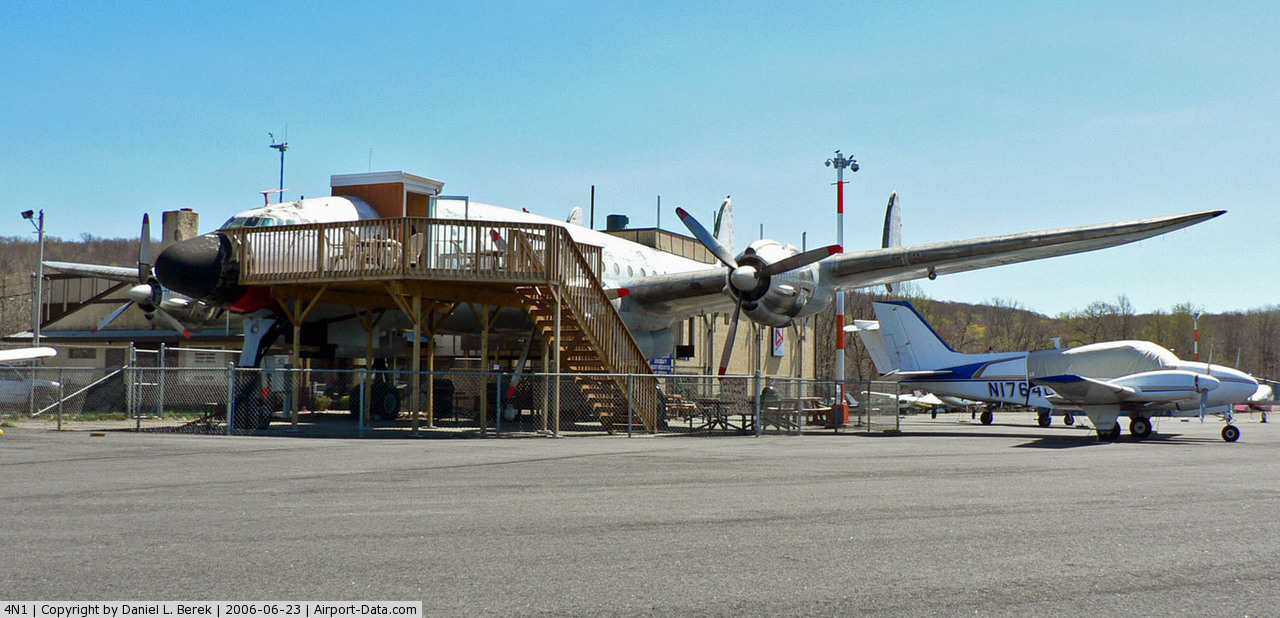
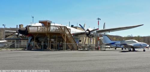
An old Lockheed Constellation sits on the ramp. This aircraft is no longer flyable, and has been built into part of the terminal building.
Trivia
- When Jungle Habitat was opened in 1972, the on-field FBO offered aerial tours in Cessna 152 and Cessna 172 aircraft painted with tiger and leopard stripes.
The above content comes from Wikipedia and is published under free licenses – click here to read more.
 |
(Click on the photo to enlarge) |
Location & QuickFacts
| FAA Information Effective: | 2008-09-25 |
| Airport Identifier: | 4N1 |
| Airport Status: | Operational |
| Longitude/Latitude: | 074-20-48.2300W/41-07-41.6320N
-74.346731/41.128231 (Estimated) |
| Elevation: | 791 ft / 241.10 m (Estimated) |
| Land: | 150 acres |
| From nearest city: | 1 nautical miles E of West Milford, NJ |
| Location: | Passaic County, NJ |
| Magnetic Variation: | 13W (1995) |
Owner & Manager
| Ownership: | Publicly owned |
| Owner: | N.j. Dept. Transportation |
| Address: | 1035 Parkway Ave. P.o. Box 610
Trenton, NJ 08625 |
| Phone number: | 609-530-2900 |
| Manager: | Tim Wagner |
| Address: | 126a Airport Rd Box 1
West Milford, NJ 07480 |
| Phone number: | 973-728-7721 |
Airport Operations and Facilities
| Airport Use: | Open to public |
| Wind indicator: | Yes |
| Segmented Circle: | No |
| Control Tower: | No |
| Lighting Schedule: | DUSK-DAWN
ACTVT MIRL RY 06/24 - CTAF. PAPI RYS 06 & 24 OPR 24 HRS. |
| Beacon Color: | Clear-Green (lighted land airport) |
| Landing fee charge: | No |
| Sectional chart: | New York |
| Region: | AEA - Eastern |
| Traffic Pattern Alt: | 1009 ft |
| Boundary ARTCC: | ZNY - New York |
| Tie-in FSS: | MIV - Millville |
| FSS on Airport: | No |
| FSS Toll Free: | 1-800-WX-BRIEF |
| NOTAMs Facility: | MIV (NOTAM-d service avaliable) |
| Federal Agreements: | N |
Airport Communications
Airport Services
| Fuel available: | 100LL |
| Airframe Repair: | MAJOR |
| Power Plant Repair: | MAJOR |
| Bottled Oxygen: | NONE |
| Bulk Oxygen: | NONE |
Runway Information
Runway 06/24
| Dimension: | 3470 x 60 ft / 1057.7 x 18.3 m
RWY 06 THLD RELOCATED 340 FT NE AND RWY 24 THLD RELOCATED 190 FT SW. |
| Surface: | ASPH, Good Condition |
| Edge Lights: | Medium |
| |
Runway 06 |
Runway 24 |
| Longitude: | 074-21-03.8760W | 074-20-30.5360W |
| Latitude: | 41-07-30.5660N | 41-07-53.8030N |
| Elevation: | 789.00 ft | 789.00 ft |
| Alignment: | 48 | 127 |
| Traffic Pattern: | Right | Left |
| Markings: | Non-precision instrument, Good Condition | Non-precision instrument, Good Condition |
| Crossing Height: | 39.00 ft | 44.00 ft |
| VASI: | 2-light PAPI on left side | 2-light PAPI on left side |
| Visual Glide Angle: | 5.75°
RWY 06 NSTD GLIDE ANGLE DUE TO TERRAIN. | 3.50° |
| Runway End Identifier: | No | No |
| Obstruction: | 192 ft trees, 1988.0 ft from runway, 170 ft right of centerline, 9:1 slope to clear | 23 ft tree, 230.0 ft from runway, 132 ft left of centerline, 1:1 slope to clear
17 FT TREE, 95 FT FM RY END, 90 FT L CNTRLN. |
|
Radio Navigation Aids
| ID |
Type |
Name |
Ch |
Freq |
Var |
Dist |
| EWR | FAN MARKER | Maryann | | | 11W | 26.6 nm |
| SKU | FAN MARKER | Stanwyck | | | 12W | 27.6 nm |
| PNJ | NDB | Paterson | | 347.00 | 12W | 14.1 nm |
| SW | NDB | Neely | | 335.00 | 14W | 22.2 nm |
| CAT | NDB | Chatham | | 254.00 | 11W | 23.6 nm |
| SKU | NDB | Stanwyck | | 261.00 | 12W | 27.6 nm |
| PO | NDB | Meier | | 403.00 | 12W | 31.9 nm |
| OGY | NDB | Bridge | | 414.00 | 12W | 39.7 nm |
| MS | NDB | Monga | | 359.00 | 12W | 44.8 nm |
| HUO | VOR/DME | Huguenot | 108X | 116.10 | 11W | 20.2 nm |
| TEB | VOR/DME | Teterboro | 021X | 108.40 | 11W | 21.2 nm |
| STW | VOR/DME | Stillwater | 033X | 109.60 | 11W | 25.0 nm |
| BWZ | VOR/DME | Broadway | 089X | 114.20 | 11W | 29.3 nm |
| LGA | VOR/DME | La Guardia | 078X | 113.10 | 12W | 29.5 nm |
| CMK | VOR/DME | Carmel | 113X | 116.60 | 12W | 35.8 nm |
| CRI | VOR/DME | Canarsie | 070X | 112.30 | 11W | 37.2 nm |
| SBJ | VOR/DME | Solberg | 076X | 112.90 | 10W | 37.4 nm |
| JFK | VOR/DME | Kennedy | 106X | 115.90 | 12W | 39.6 nm |
| IGN | VOR/DME | Kingston | 123X | 117.60 | 12W | 40.0 nm |
| COL | VOR/DME | Colts Neck | 101X | 115.40 | 11W | 49.8 nm |
| SAX | VORTAC | Sparta | 104X | 115.70 | 11W | 9.4 nm |
| JFK | VOT | Kennedy | | 115.10 | | 39.3 nm |
Remarks
- RY 06/24 STEEP ROCK LEDGES LCTD JUST BYD BOTH RY ENDS.
- ARPT SUBJECT TO GUSTING WIND & FREQUEND XWINDS.
- SOME RY AND TY LGTS TALLER THAN STANDARD.
- GCO AVBL ON FREQ 121.725 THRU NYAI FSS.
- DEER AND BIRDS ON AND INVOF ARPT.
- RECOMMENDED THAT WIRES RWY 6 APCH BE MKD WITH PLASTIC BALLS OR PUT UNDERGND (WIRES NOW MKD & LGTS MOUNTED ON POLES).
Images and information placed above are from
http://www.airport-data.com/airport/4N1/
We thank them for the data!
| General Info
|
| Country |
United States
|
| State |
NEW JERSEY
|
| FAA ID |
4N1
|
| Latitude |
41-07-41.632N
|
| Longitude |
074-20-48.230W
|
| Elevation |
791 feet
|
| Near City |
WEST MILFORD
|
We don't guarantee the information is fresh and accurate. The data may
be wrong or outdated.
For more up-to-date information please refer to other sources.
|
|