 |
|
Location & QuickFacts
| FAA Information Effective: | 2008-09-25 |
| Airport Identifier: | NJ55 |
| Airport Status: | Operational |
| Longitude/Latitude: | 074-01-58.4990W/40-19-00.3980N
-74.032916/40.316777 (Estimated) |
| Elevation: | 25 ft / 7.62 m (Estimated) |
| Land: | 0 acres |
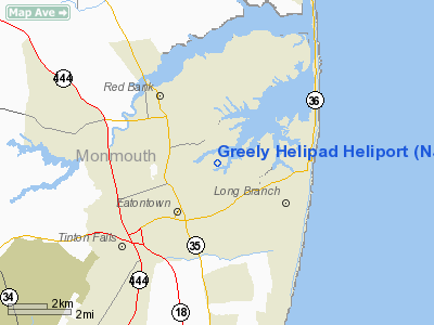
| From nearest city: | 0 nautical miles of Fort Monmouth, NJ |
| Location: | Monmouth County, NJ |
| Magnetic Variation: | 12W (1985) |
Owner & Manager
| Ownership: | Army owned |
| Owner: | Us Army Atca-aso |
| Address: | Cameron Station
Alexandria, VA 22314 |
| Address: |
|
Airport Operations and Facilities
| Airport Use: | Private |
| Segmented Circle: | No |
| Control Tower: | No |
| Sectional chart: | New York |
| Region: | AEA - Eastern |
| Boundary ARTCC: | ZNY - New York |
| Tie-in FSS: | MIV - Millville |
| FSS on Airport: | No |
| FSS Toll Free: | 1-800-WX-BRIEF |
| NOTAMs Facility: | MIV |
Runway Information
Helipad H1
| Dimension: | 50 x 50 ft / 15.2 x 15.2 m |
| Surface: | TURF, |
| |
Runway H1 |
Runway |
| Traffic Pattern: | Left | Left |
|
Radio Navigation Aids
| ID |
Type |
Name |
Ch |
Freq |
Var |
Dist |
| EWR | FAN MARKER | Maryann | | | 11W | 24.3 nm |
| OGY | NDB | Bridge | | 414.00 | 12W | 16.6 nm |
| NEL | NDB | Lakehurst | | 396.00 | 13W | 21.5 nm |
| CAT | NDB | Chatham | | 254.00 | 11W | 31.3 nm |
| BBN | NDB | Babylon | | 275.00 | 14W | 36.5 nm |
| PNJ | NDB | Paterson | | 347.00 | 12W | 38.2 nm |
| DYL | NDB | Doylestown | | 237.00 | 10W | 49.9 nm |
| NEL | TACAN | Lakehurst | 055X | | 11W | 22.3 nm |
| NEL | UHF/NDB | Lakehurst | | 274.80 | 13W | 21.5 nm |
| PNE | VOR | North Philadelphia | | 112.00 | 10W | 47.0 nm |
| COL | VOR/DME | Colts Neck | 101X | 115.40 | 11W | 5.8 nm |
| CRI | VOR/DME | Canarsie | 070X | 112.30 | 11W | 18.9 nm |
| JFK | VOR/DME | Kennedy | 106X | 115.90 | 12W | 22.5 nm |
| LGA | VOR/DME | La Guardia | 078X | 113.10 | 12W | 29.2 nm |
| TEB | VOR/DME | Teterboro | 021X | 108.40 | 11W | 32.0 nm |
| SBJ | VOR/DME | Solberg | 076X | 112.90 | 10W | 36.2 nm |
| ARD | VOR/DME | Yardley | 019X | 108.20 | 10W | 40.3 nm |
| DPK | VOR/DME | Deer Park | 124X | 117.70 | 12W | 43.9 nm |
| BWZ | VOR/DME | Broadway | 089X | 114.20 | 11W | 46.2 nm |
| RBV | VORTAC | Robbinsville | 085X | 113.80 | 10W | 22.3 nm |
| GXU | VORTAC | Mc Guire | 043X | 110.60 | 11W | 31.8 nm |
| CYN | VORTAC | Coyle | 081X | 113.40 | 10W | 35.2 nm |
| JFK | VOT | Kennedy | | 115.10 | | 22.3 nm |
Remarks
- (E137-1) PPR, CTC ARMY FLT OPERS THRU FT MONMOUTH AUTOVON 992-6115.
- (E137-2) MAKE APCH & DEP TO CENTER OF PARADE GROUND & HOVER TO PRK RAMP IN NE CORNER.
- (E137-3) OPEN DAYS TO VIP CODE 6 OR ABOVE & ALL EMERG. CTN: SURROUNDED BY BLDG, PLINE & TREES.
- (E137-4) FUEL AVBL LAKEFRONT NAS. CTC OPERNS AT LEAST 15 MIN PRIOR TO LNDG SO FIRE TRUCK MAY BE DISPATCHED. APCH FROM W OR E QUAD ONLY.
Images and information placed above are from
http://www.airport-data.com/airport/NJ55/
We thank them for the data!
| General Info
|
| Country |
United States
|
| State |
NEW JERSEY
|
| FAA ID |
NJ55
|
| Latitude |
40-19-00.398N
|
| Longitude |
074-01-58.499W
|
| Elevation |
25 feet
|
| Near City |
FORT MONMOUTH
|
We don't guarantee the information is fresh and accurate. The data may
be wrong or outdated.
For more up-to-date information please refer to other sources.
|
|


