 |
|
Coordinates: 39°56′03.4″N 074°48′26.1″W / 39.934278°N 74.80725°W / 39.934278; -74.80725
| Flying W Airport |
| IATA: none – ICAO: none – FAA LID: N14 |
| Summary |
| Airport type |
Public use |
| Owner |
Cave Holdings - Flying W, LLC |
| Operator |
Mindy Redner |
| Serves |
Lumberton Township, New Jersey |
| Location |
Burlington County, New Jersey |
| Elevation AMSL |
49 ft / 15 m |
| Runways |
| Direction |
Length |
Surface |
| ft |
m |
| 1/19 |
3,496 |
1,066 |
Asphalt |
| Statistics (2008) |
| Aircraft operations |
34.989 |
| Based aircraft |
122 |
| Source: Federal Aviation Administration |
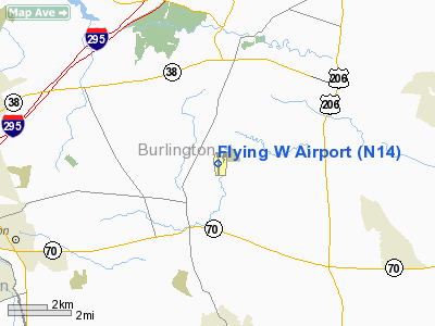
Flying W Airport (FAA LID: N14) is a public-use airport located one nautical miles (1.852 km) southwest of the central business district of Lumberton Township in Burlington County, New Jersey, United States. The airport is privately owned.. The street address is 66 Fostertown Road, Medford, NJ 08055.
The above content comes from Wikipedia and is published under free licenses – click here to read more.
Location & QuickFacts
| FAA Information Effective: | 2008-09-25 |
| Airport Identifier: | N14 |
| Airport Status: | Operational |
| Longitude/Latitude: | 074-48-26.1000W/39-56-03.4000N
-74.807250/39.934278 (Estimated) |
| Elevation: | 49 ft / 14.94 m (Surveyed) |
| Land: | 170 acres |
| From nearest city: | 1 nautical miles SW of Lumberton, NJ |
| Location: | Burlington County, NJ |
| Magnetic Variation: | 13W (2000) |
Owner & Manager
| Ownership: | Privately owned |
| Owner: | Cave Holdings-flying W, Llc |
| Address: | 66 Fostertown Rd
Medford, NJ 08055 |
| Phone number: | 609-261-7880 |
| Manager: | Mindy Redner |
| Address: | 60 Fostertown Rd
Medford, NJ 08055 |
| Phone number: | 609-267-7673 |
Airport Operations and Facilities
| Airport Use: | Open to public |
| Wind indicator: | Yes |
| Segmented Circle: | Yes |
| Control Tower: | No |
| Lighting Schedule: | DUSK-DAWN
ACTVT MIRL, PAPI, REIL AND TWY LGTS - CTAF. |
| Beacon Color: | Clear-Green (lighted land airport) |
| Landing fee charge: | No |
| Sectional chart: | Washington |
| Region: | AEA - Eastern |
| Boundary ARTCC: | ZDC - Washington |
| Responsible ARTCC: | ZNY - New York |
| Tie-in FSS: | MIV - Millville |
| FSS on Airport: | No |
| FSS Toll Free: | 1-800-WX-BRIEF |
| NOTAMs Facility: | MIV (NOTAM-d service avaliable) |
| Federal Agreements: | N |
Airport Communications
| CTAF: | 122.800 |
| Unicom: | 122.800 |
Airport Services
| Fuel available: | 100LLA |
| Airframe Repair: | MAJOR |
| Power Plant Repair: | MAJOR |
Runway Information
Runway 01/19
| Dimension: | 3496 x 75 ft / 1065.6 x 22.9 m |
| Surface: | ASPH, Good Condition |
| Edge Lights: | Medium |
| |
Runway 01 |
Runway 19 |
| Longitude: | 074-48-25.1455W | 074-48-26.9540W |
| Latitude: | 39-55-46.1769N | 39-56-20.7011N |
| Elevation: | 35.00 ft | 49.00 ft |
| Alignment: | 127 | 127 |
| Traffic Pattern: | Right | Left |
| Markings: | Basic, Good Condition | Basic, Good Condition |
| VASI: | 2-light PAPI on left side | 2-light PAPI on left side |
| Visual Glide Angle: | 3.50° | 3.25° |
| Runway End Identifier: | Yes | Yes |
| Obstruction: | 85 ft trees, 262.0 ft from runway, 169 ft right of centerline
TREE +36 FT HIGH, 43 FT FM THLD, 102 FT R. | 52 ft trees, 641.0 ft from runway, 255 ft right of centerline, 8:1 slope to clear |
|
Radio Navigation Aids
| ID |
Type |
Name |
Ch |
Freq |
Var |
Dist |
| NXX | NDB | Willow Grove | | 388.00 | 12W | 21.8 nm |
| NEL | NDB | Lakehurst | | 396.00 | 13W | 22.7 nm |
| ING | NDB | Ambler | | 275.00 | 11W | 24.8 nm |
| DYL | NDB | Doylestown | | 237.00 | 10W | 28.1 nm |
| RNB | NDB | Rainbow | | 363.00 | 11W | 34.5 nm |
| UKT | NDB | Quakertown | | 208.00 | 12W | 37.1 nm |
| NEL | TACAN | Lakehurst | 055X | | 11W | 21.8 nm |
| NXX | TACAN | Willow Grove | 061X | | 10W | 22.1 nm |
| NEL | UHF/NDB | Lakehurst | | 274.80 | 13W | 22.7 nm |
| PNE | VOR | North Philadelphia | | 112.00 | 10W | 12.9 nm |
| ARD | VOR/DME | Yardley | 019X | 108.20 | 10W | 19.7 nm |
| CKZ | VOR/DME | Pennridge | 025Y | 108.85 | 12W | 35.3 nm |
| COL | VOR/DME | Colts Neck | 101X | 115.40 | 11W | 37.4 nm |
| SBJ | VOR/DME | Solberg | 076X | 112.90 | 10W | 39.1 nm |
| GXU | VORTAC | Mc Guire | 043X | 110.60 | 11W | 10.7 nm |
| CYN | VORTAC | Coyle | 081X | 113.40 | 10W | 18.7 nm |
| RBV | VORTAC | Robbinsville | 085X | 113.80 | 10W | 21.6 nm |
| VCN | VORTAC | Cedar Lake | 099X | 115.20 | 10W | 25.0 nm |
| OOD | VORTAC | Woodstown | 075X | 112.80 | 10W | 29.1 nm |
| ACY | VORTAC | Atlantic City | 023X | 108.60 | 10W | 30.7 nm |
| PTW | VORTAC | Pottstown | 112X | 116.50 | 09W | 38.7 nm |
| MXE | VORTAC | Modena | 079X | 113.20 | 09W | 39.8 nm |
| DQO | VORTAC | Dupont | 087X | 114.00 | 10W | 40.0 nm |
| PHL | VOT | Philadelphia Intl | | 109.80 | | 20.5 nm |
Remarks
- EAST-WEST RAVINE CROSSES EXTD CNTRLN RWY 01, 100 FT FM THLD.
- DEEP RETENTION POND 23 FT WEST OF PARALLEL TWY CNTRLN, NORTH OF OPS BLDG.
- GCO AVBL ON FREQ 121.725 THRU NYAI FSS .
Images and information placed above are from
http://www.airport-data.com/airport/N14/
We thank them for the data!
| General Info
|
| Country |
United States
|
| State |
NEW JERSEY
|
| FAA ID |
N14
|
| Latitude |
39-56-03.400N
|
| Longitude |
074-48-26.100W
|
| Elevation |
49 feet
|
| Near City |
LUMBERTON
|
We don't guarantee the information is fresh and accurate. The data may
be wrong or outdated.
For more up-to-date information please refer to other sources.
|
|


