|
|
Coordinates: 40°52′31″N 074°16′53″W / 40.87528°N 74.28139°W / 40.87528; -74.28139
| Essex County Airport |
 |
| IATA: CDW – ICAO: KCDW – FAA LID: CDW |
| Summary |
| Airport type |
Public |
| Owner |
Essex County Improvement Authority |
| Serves |
Caldwell, New Jersey, U.S. |
| Location |
Fairfield Township, Essex County, New Jersey, U.S. |
| Elevation AMSL |
173 ft / 53 m |
| Website |
www.flycdw.com |
| Runways |
| Direction |
Length |
Surface |
| ft |
m |
| 4/22 |
4,553 |
1,388 |
Asphalt |
| 10/28 |
3,721 |
1,134 |
Asphalt |
| Statistics (2009) |
| Aircraft operations |
245,872 |
| Based aircraft |
281 |
| Source: Federal Aviation Administration |
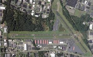
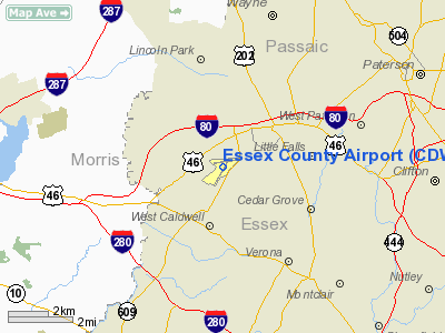
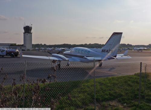
Airport layout diagram Essex County Airport (IATA: CDW, ICAO: KCDW, FAA LID: CDW) is a public airport located two miles (3 km) north of the central business district of Caldwell, a borough of northwestern Essex County in the U.S. state of New Jersey. It is owned by the Essex County Improvement Authority and is a popular general aviation airport for aircraft traveling to New York City and northern New Jersey.
Although the FAA officially lists the airport's location as Caldwell and the FAA/IATA identifier "CDW" is an abbreviation of "Caldwell Wright" from the history of this field, the airport buildings and grounds are located entirely in Fairfield Township. The FAA control tower at Essex County Airport is officially called Caldwell Tower. History
In April 1929 Essex Airport Corporation was formed by Walter Marvin and six other individuals. The intention of the company was to open an airport to serve Montclair, New Jersey, a town seven miles away. The tract of land that Essex Airport Corporation intended for the airport was the Fairfield Dairy Company land that had also been used during WWI as a temporary airfield for the Naval Rifle Range which had been located along the Passaic River in Pine Brook. Some of the early references to airport have the designation “Marvin Airport”, named after Walter Marvin.
The airport gained national attention when John F. Kennedy, Jr., who based his private aircraft there, crashed hours after departing the airport en route for Martha's Vineyard Airport with his wife and sister-in-law on July 16, 1999.
Traffic
For the 12-month period ending January 1, 2006, the airport had 245,872 aircraft operations, an average of 673 per day: 98% general aviation, 2% air taxi and <1% military. At that time there were 281 aircraft based at this airport: 79% single-engine, 19% multi-engine and 2% helicopter.
Facilities
Essex County Airport covers an area of 275 acres (111 ha) which contains two asphalt paved runways: 4/22 measuring 4,553 x 80 ft (1,388 x 24 m) and 10/28 measuring 3,721 x 75 ft (1,134 x 23 m).
Businesses and government
- Air Bound Aviation - Fixed Base Operator
- Air Fleet Training Systems - flight school
- Avantair - Fixed Base Operator & fractional operator
- C&W Aero Services - aircraft maintenance
- Century Flight Academy - flight school
- Paragon Aircraft - aircraft maintenance
- Pro Star Pilatus - aircraft sales
- RGI Aviation - flight school
- United States Coast Guard Auxiliary - Air Station Caldwell, Flotilla 10-20
The above content comes from Wikipedia and is published under free licenses – click here to read more.
 |
(Click on the photo to enlarge) |
Location & QuickFacts
| FAA Information Effective: | 2008-09-25 |
| Airport Identifier: | CDW |
| Airport Status: | Operational |
| Longitude/Latitude: | 074-16-52.8840W/40-52-30.8020N
-74.281357/40.875223 (Estimated) |
| Elevation: | 173 ft / 52.73 m (Surveyed) |
| Land: | 275 acres |
| From nearest city: | 2 nautical miles N of Caldwell, NJ |
| Location: | Essex County, NJ |
| Magnetic Variation: | 13W (1985) |
Owner & Manager
| Ownership: | Publicly owned |
| Owner: | Essex County Improvement Authority |
| Address: | 155 Passaic Avenue
Fairfield, NJ 07004 |
| Phone number: | 973-575-0952 |
| Manager: | Tom Gomez |
| Address: | 155 Passaic Avenue
Fairfield, NJ 07004 |
| Phone number: | 973-227-4567 |
Airport Operations and Facilities
| Airport Use: | Open to public |
| Wind indicator: | Yes |
| Segmented Circle: | No |
| Control Tower: | Yes |
| Lighting Schedule: | DUSK-DAWN
WHEN ATCT CLSD, MIRL RY 10/28 AND HIRL RY 04/22 PRESET MEDIUM INTST. REIL RY 22 AVBL HIGH INTST ONLY. ACTVT HIRL RY 04/22 & REIL RY 22 - CTAF. |
| Beacon Color: | Clear-Green (lighted land airport)
AIRPORT BEACON LOCATED ON TOP OF CONTROL TOWER |
| Landing fee charge: | Yes |
| Sectional chart: | New York |
| Region: | AEA - Eastern |
| Boundary ARTCC: | ZNY - New York |
| Tie-in FSS: | MIV - Millville |
| FSS on Airport: | No |
| FSS Toll Free: | 1-800-WX-BRIEF |
| NOTAMs Facility: | CDW (NOTAM-d service avaliable) |
| Federal Agreements: | NGY |
Airport Communications
| CTAF: | 119.800 |
| Unicom: | 122.950 |
Airport Services
| Fuel available: | 100LLA |
| Airframe Repair: | MAJOR |
| Power Plant Repair: | MAJOR |
| Bottled Oxygen: | LOW |
| Bulk Oxygen: | NONE |
Runway Information
Runway 04/22
| Dimension: | 4553 x 80 ft / 1387.8 x 24.4 m |
| Surface: | ASPH, Good Condition |
| Weight Limit: | Single wheel: 30000 lbs. |
| Edge Lights: | High |
| |
Runway 04 |
Runway 22 |
| Longitude: | 074-17-10.8310W | 074-16-41.5650W |
| Latitude: | 40-52-03.9210N | 40-52-43.0390N |
| Elevation: | 173.00 ft | 173.00 ft |
| Alignment: | 30 | 127 |
| ILS Type: | | LOCALIZER
|
| Traffic Pattern: | Left | Right |
| Markings: | Basic, Good Condition | Basic, Good Condition |
| Crossing Height: | 0.00 ft | 42.00 ft |
| Displaced threshold: | 371.00 ft | 135.00 ft |
| VASI: | | 4-light PAPI on right side
RY 22 PAPI UNUSABLE BYD 5 DEGREES RIGHT OF CENTERLINE DUE TO OBSTRUCTION. |
| Visual Glide Angle: | 0.00° | 3.00° |
| Runway End Identifier: | No | Yes |
| Obstruction: | 42 ft tree, 220.0 ft from runway, 137 ft left of centerline
APCH RATIO 15:1 TO DSPLCD THR. | 88 ft trees, 400.0 ft from runway, 245 ft right of centerline, 2:1 slope to clear
APCH RATIO 6:1 TO DSPLCD THLD.
6 FT FENCE, 200 FT FM RY END, ACROSS CNTRLN. |
|
Runway 10/28
| Dimension: | 3721 x 75 ft / 1134.2 x 22.9 m |
| Surface: | ASPH, Good Condition |
| Weight Limit: | Single wheel: 12500 lbs. |
| Edge Lights: | Medium |
| |
Runway 10 |
Runway 28 |
| Longitude: | 074-17-12.8340W | 074-16-24.7710W |
| Latitude: | 40-52-37.5810N | 40-52-41.9590N |
| Elevation: | 170.00 ft | 173.00 ft |
| Alignment: | 83 | 127 |
| Traffic Pattern: | Left | Right |
| Markings: | Basic, Good Condition | Basic, Good Condition |
| Displaced threshold: | 166.00 ft | 825.00 ft |
| Runway End Identifier: | No | No |
| Obstruction: | 35 ft tree, 264.0 ft from runway
RY 10 APCH SLOPE 13:1 TO DSPLCD THLD. | 42 ft tree, 423.0 ft from runway, 123 ft left of centerline, 5:1 slope to clear
RY 28 APCH RATIO 32:1 TO DSPLCD THLD.
6 FT FENCE, 195 FT FM RY END, 120 FT LT OF CNTRLN. |
|
Radio Navigation Aids
| ID |
Type |
Name |
Ch |
Freq |
Var |
Dist |
| EWR | FAN MARKER | Maryann | | | 11W | 11.2 nm |
| SKU | FAN MARKER | Stanwyck | | | 12W | 40.7 nm |
| PNJ | NDB | Paterson | | 347.00 | 12W | 7.3 nm |
| CAT | NDB | Chatham | | 254.00 | 11W | 10.5 nm |
| OGY | NDB | Bridge | | 414.00 | 12W | 25.9 nm |
| SW | NDB | Neely | | 335.00 | 14W | 36.8 nm |
| SKU | NDB | Stanwyck | | 261.00 | 12W | 40.7 nm |
| BBN | NDB | Babylon | | 275.00 | 14W | 42.6 nm |
| PO | NDB | Meier | | 403.00 | 12W | 44.4 nm |
| NEL | NDB | Lakehurst | | 396.00 | 13W | 50.0 nm |
| NEL | UHF/NDB | Lakehurst | | 274.80 | 13W | 50.0 nm |
| TEB | VOR/DME | Teterboro | 021X | 108.40 | 11W | 10.1 nm |
| LGA | VOR/DME | La Guardia | 078X | 113.10 | 12W | 19.1 nm |
| CRI | VOR/DME | Canarsie | 070X | 112.30 | 11W | 23.7 nm |
| BWZ | VOR/DME | Broadway | 089X | 114.20 | 11W | 25.0 nm |
| SBJ | VOR/DME | Solberg | 076X | 112.90 | 10W | 27.4 nm |
| JFK | VOR/DME | Kennedy | 106X | 115.90 | 12W | 27.4 nm |
| STW | VOR/DME | Stillwater | 033X | 109.60 | 11W | 27.7 nm |
| COL | VOR/DME | Colts Neck | 101X | 115.40 | 11W | 34.3 nm |
| HUO | VOR/DME | Huguenot | 108X | 116.10 | 11W | 35.1 nm |
| CMK | VOR/DME | Carmel | 113X | 116.60 | 12W | 40.0 nm |
| DPK | VOR/DME | Deer Park | 124X | 117.70 | 12W | 44.7 nm |
| ARD | VOR/DME | Yardley | 019X | 108.20 | 10W | 47.1 nm |
| SAX | VORTAC | Sparta | 104X | 115.70 | 11W | 16.4 nm |
| RBV | VORTAC | Robbinsville | 085X | 113.80 | 10W | 41.6 nm |
| JFK | VOT | Kennedy | | 115.10 | | 27.1 nm |
Remarks
- TURBO JET ACFT LNDG & TKOFS RESTRICTED TO RY 04/22; LNDG RY 10/28 RESTRICTED TO 12500 LBS & BELOW.
- DEER & BIRDS ON & INVOF ARPT.
- LCL OPNS SUSPENDED FROM 2300-0700 MON THRU SAT 2300 SAT UNTIL 1000 SUN.
- FIXED WING VFR ACFT DEP: RY 4 - FROM DEP END RY HEADING FOR 1 MI THEN IF REMAINING IN THE PAT TURN TO CROSSWIND; IF DEP PAT CONTINUE STRAIGHT OUT OR EXIT WITH 45 DEG LEFT TURN AFTER REACHING PAT ALT.
- FIXED WING VFR ACFT DEP: RY 10 - FROM DEP END TURN LEFT HEADING 080 UNTIL 900 FT MSL THEN IF REMAINING IN THE PATTERN TURN TO CROSSWIND; IF DEPARTING PATTERN CONTINUE STRAIGHT OUT OR EXIT WITH A 45 DEG LEFT TURN AFTER REACHING PAT ALT.
- FIXED WING VFR ACFT DEP: RY 22 - FROM DEP END TURN RIGHT HEADING 230 UNTIL 900 FT MSL THEN IF REMAINING IN THE PATTERN TURN TO CROSSWIND; IF DEPARTING PATTERN CONTINUE STRAIGHT OUT OR EXIT WITH A 45 DEG RIGHT TURN AFTER REACHING PAT ALT.
- FIXED WING VFR ACFT DEP: RY 28 - FROM DEP END RY HEADING FOR 1 MI THEN IF REMAINING IN THE PAT TURN TO CROSSWIND; IF DEPARTING PAT CONTINUE STRAIGHT OUT OR EXIT WITH A 45 DEG RIGHT TURN AFTER REACHING PAT ALT.
- PILOTS BE ALERT -- THE TETERBORO VOR/DME OR GPS-A; THE PASSAIC RIVER VISUAL RY 06 & CEDAR GROVE VISUAL RY 01 APCHS TRANSIT ESSEX COUNTY ARPT CLASS D AIRSPACE. TRAFFIC PASSES NORTH OF THE ARPT DESCENDING FROM 3000 FT MSL TO 2000 FT MSL.
- PILOTS BE ALERT -- THE MORRISTOWN ILS & NDB OR GPS RY 23 APCHS TRANSIT ESSEX COUNTY ARPT CLASS D AIRSPACE. TRAFFIC PASSES TWO MILES WEST OF THE ARPT DESCENDING THROUGH 2000 FT MSL.
- 7 DEG APCH SLOPE RQRD TO CLEAR TREES TO LNDG THR RY 22.
Images and information placed above are from
http://www.airport-data.com/airport/CDW/
We thank them for the data!
| General Info
|
| Country |
United States
|
| State |
NEW JERSEY
|
| FAA ID |
CDW
|
| Latitude |
40-52-30.802N
|
| Longitude |
074-16-52.884W
|
| Elevation |
173 feet
|
| Near City |
CALDWELL
|
We don't guarantee the information is fresh and accurate. The data may
be wrong or outdated.
For more up-to-date information please refer to other sources.
|
|