|
|
Coordinates: 39°42′19.713″N 075°01′58.411″W / 39.70547583°N 75.03289194°W / 39.70547583; -75.03289194
| Cross Keys Airport |
| IATA: none – ICAO: none – FAA LID: 17N |
| Summary |
| Airport type |
Public use |
| Owner |
Cross Keys Airport Inc. |
| Operator |
Hank Ostrosky |
| Serves |
Cross Keys, New Jersey |
| Location |
Gloucester County, New Jersey |
| Elevation AMSL |
162 ft / 49 m |
| Runways |
| Direction |
Length |
Surface |
| ft |
m |
| 9/27 |
3,500 |
1,067 |
Asphalt |
| Statistics (2009) |
| Aircraft operations |
30,600 |
| Based aircraft |
45 |
| Source: Federal Aviation Administration |
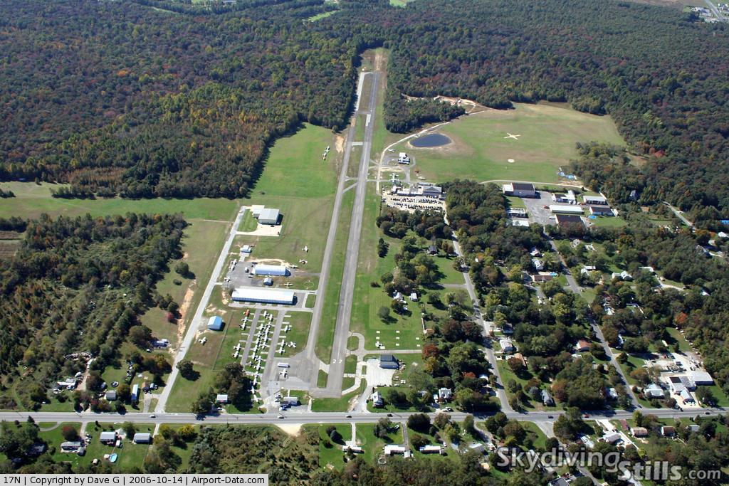
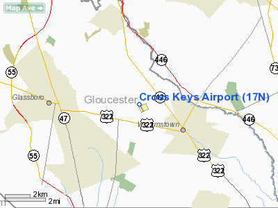
Cross Keys Airport (FAA LID: 17N) is a public-use airport located one nautical miles (1.852 km) south of the Cross Keys area of Monroe Township in Gloucester County, New Jersey, United States. The airport is privately owned.. A skydiving operation is based at the airport.
History
Cross Keys Airport made international news on May 25, 2006 when several F-16 jets escorted a Cessna aircraft to land there after it strayed into a 30 mile restricted area temporarily imposed during the visit of President George W. Bush to a town in Pennsylvania. The pilot was said to be "in radio contact... compliant."
The above content comes from Wikipedia and is published under free licenses – click here to read more.
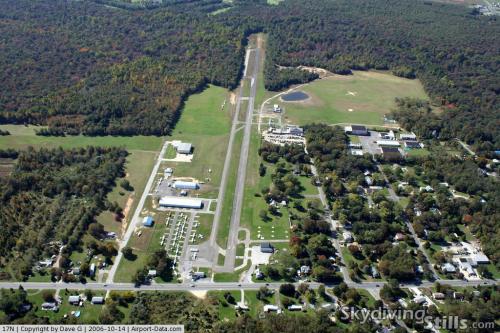 |
(Click on the photo to enlarge) |
Location & QuickFacts
| FAA Information Effective: | 2008-09-25 |
| Airport Identifier: | 17N |
| Airport Status: | Operational |
| Longitude/Latitude: | 075-01-58.8110W/39-42-19.7130N
-75.033003/39.705476 (Estimated) |
| Elevation: | 162 ft / 49.38 m (Estimated) |
| Land: | 280 acres |
| From nearest city: | 1 nautical miles S of Cross Keys, NJ |
| Location: | Gloucester County, NJ |
| Magnetic Variation: | 10W (1980) |
Owner & Manager
| Ownership: | Privately owned |
| Owner: | Cross Keys Airport Inc |
| Address: | 1531 N. Tuckahoe Road
Williamstown, NJ 08094 |
| Phone number: | 856-629-3033 |
| Manager: | Andrew Weiner |
| Address: | 1531 N. Tuckahoe Road
Williamstown, NJ 08094 |
| Phone number: | 856-629-3033 |
Airport Operations and Facilities
| Airport Use: | Open to public |
| Wind indicator: | Yes
ARPT WINDSOCK LCTD ON HANGAR SOUTH OF RY. |
| Segmented Circle: | Yes |
| Control Tower: | No |
| Lighting Schedule: | RDO-CTL
ACTVT LIRL RY 09/27 - CTAF. |
| Landing fee charge: | No |
| Sectional chart: | Washington |
| Region: | AEA - Eastern |
| Traffic Pattern Alt: | 838 ft |
| Boundary ARTCC: | ZDC - Washington |
| Responsible ARTCC: | ZNY - New York |
| Tie-in FSS: | MIV - Millville |
| FSS on Airport: | No |
| FSS Toll Free: | 1-800-WX-BRIEF |
| NOTAMs Facility: | MIV (NOTAM-d service avaliable) |
| Federal Agreements: | N |
Airport Communications
| CTAF: | 122.800 |
| Unicom: | 122.800 |
Airport Services
| Fuel available: | 100LL |
| Airframe Repair: | MAJOR |
| Power Plant Repair: | MAJOR |
| Bottled Oxygen: | NONE |
| Bulk Oxygen: | NONE |
Runway Information
Runway 09/27
| Dimension: | 3500 x 50 ft / 1066.8 x 15.2 m |
| Surface: | ASPH, Poor Condition
RWY 09/27 ASPH CRACKED/LOOSE. |
| Weight Limit: | Single wheel: 13000 lbs. |
| Edge Lights: | Non-standard lighting system
RY 09/27 NSTD LIRL. ALL LIGHT SPACING NSTD. RY 27 RY END LGTS MISSING. RY 09 NO YELLOW CAUTION ZONE LGTS. |
| |
Runway 09 |
Runway 27 |
| Longitude: | 075-02-20.3140W | 075-01-37.2730W |
| Latitude: | 39-42-14.9490N | 39-42-24.5010N |
| Elevation: | 137.00 ft | 161.00 ft |
| Alignment: | 74 | 127 |
| Traffic Pattern: | Right | Left |
| Markings: | Basic, Fair Condition
RY 09/27 MKGS FADED. | Nonstandard, Fair Condition |
| Displaced threshold: | 0.00 ft | 200.00 ft
DSPLCD THLD MARKED WITH LGTS. |
| Runway End Identifier: | | No |
| Centerline Lights: | No | No |
| Touchdown Lights: | No | No |
| Obstruction: | 60 ft trees, 230.0 ft from runway, 80 ft left of centerline
TREES ARE 125' R & L OF CNTRL EXTNDD.
+60 FT TREES 200 FT RT & LFT OF EXTD CTLN AT APP END. | 73 ft tree, 370.0 ft from runway, 135 ft right of centerline, 2:1 slope to clear
APP RATIO 8:1 TO DSPLCD THLD.
+40 FT TREE 180 FT FM RY END & 25 FT R. APP RATIO 9:1 TO DSPLCD THLD. |
|
Radio Navigation Aids
| ID |
Type |
Name |
Ch |
Freq |
Var |
Dist |
| RNB | NDB | Rainbow | | 363.00 | 11W | 17.9 nm |
| ING | NDB | Ambler | | 275.00 | 11W | 27.8 nm |
| NXX | NDB | Willow Grove | | 388.00 | 12W | 29.5 nm |
| NEL | NDB | Lakehurst | | 396.00 | 13W | 38.1 nm |
| DYL | NDB | Doylestown | | 237.00 | 10W | 38.1 nm |
| UKT | NDB | Quakertown | | 208.00 | 12W | 44.9 nm |
| NXX | TACAN | Willow Grove | 061X | | 10W | 29.9 nm |
| NEL | TACAN | Lakehurst | 055X | | 11W | 37.2 nm |
| DOV | TACAN | Dover | 037X | | 09W | 39.9 nm |
| NEL | UHF/NDB | Lakehurst | | 274.80 | 13W | 38.1 nm |
| PNE | VOR | North Philadelphia | | 112.00 | 10W | 22.7 nm |
| ARD | VOR/DME | Yardley | 019X | 108.20 | 10W | 33.4 nm |
| CKZ | VOR/DME | Pennridge | 025Y | 108.85 | 12W | 42.8 nm |
| VCN | VORTAC | Cedar Lake | 099X | 115.20 | 10W | 10.5 nm |
| OOD | VORTAC | Woodstown | 075X | 112.80 | 10W | 13.2 nm |
| ACY | VORTAC | Atlantic City | 023X | 108.60 | 10W | 25.9 nm |
| DQO | VORTAC | Dupont | 087X | 114.00 | 10W | 26.6 nm |
| GXU | VORTAC | Mc Guire | 043X | 110.60 | 11W | 27.2 nm |
| CYN | VORTAC | Coyle | 081X | 113.40 | 10W | 28.6 nm |
| MXE | VORTAC | Modena | 079X | 113.20 | 09W | 32.1 nm |
| ENO | VORTAC | Smyrna | 051X | 111.40 | 09W | 36.2 nm |
| SIE | VORTAC | Sea Isle | 095X | 114.80 | 09W | 38.2 nm |
| RBV | VORTAC | Robbinsville | 085X | 113.80 | 10W | 38.8 nm |
| PTW | VORTAC | Pottstown | 112X | 116.50 | 09W | 39.4 nm |
| PHL | VOT | Philadelphia Intl | | 109.80 | | 13.9 nm |
Remarks
- DUE TO PARACHUTE DROP ZONE ON NORTH SIDE OF ARPT ALL TRAFFIC IS TO REMAIN SOUTH OF RY 09/27.
- RY 27 ROAD, FENCE, BLDGS, & TREES NEAR APCH END.
- DEER & BIRDS ON & INVOF ARPT.
- SOME RWY HOLD MARKINGS ON TWYS NSTD DIMENSIONS, CONFIGURATION AND/OR PLACEMENT.
- GCO AVBL ON FREQ 121.725 THRU ISLIP FSS.
Images and information placed above are from
http://www.airport-data.com/airport/17N/
We thank them for the data!
| General Info
|
| Country |
United States
|
| State |
NEW JERSEY
|
| FAA ID |
17N
|
| Latitude |
39-42-19.713N
|
| Longitude |
075-01-58.811W
|
| Elevation |
162 feet
|
| Near City |
CROSS KEYS
|
We don't guarantee the information is fresh and accurate. The data may
be wrong or outdated.
For more up-to-date information please refer to other sources.
|
|