 |
|
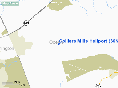
Location & QuickFacts
| FAA Information Effective: | 2008-09-25 |
| Airport Identifier: | 36NJ |
| Airport Status: | Operational |
| Longitude/Latitude: | 074-26-28.5420W/40-03-48.4110N
-74.441262/40.063447 (Estimated) |
| Elevation: | 130 ft / 39.62 m (Estimated) |
| Land: | 15 acres |
| From nearest city: | 4 nautical miles SW of Cassville, NJ |
| Location: | Ocean County, NJ |
| Magnetic Variation: | 12W (1985) |
Owner & Manager
| Ownership: | Publicly owned |
| Owner: | Nj Forest Fire Service |
| Address: | Cn 404 501 East State St
Trenton, NJ 08625 |
| Phone number: | 609-292-2977 |
| Manager: | David B. Harrison |
| Address: |
|
Airport Operations and Facilities
| Airport Use: | Private |
| Wind indicator: | Yes |
| Segmented Circle: | No |
| Control Tower: | No |
| Landing fee charge: | No |
| Sectional chart: | New York |
| Region: | AEA - Eastern |
| Boundary ARTCC: | ZNY - New York |
| Tie-in FSS: | MIV - Millville |
| FSS on Airport: | No |
| FSS Toll Free: | 1-800-WX-BRIEF |
Runway Information
Runway 09/27
| Dimension: | 1800 x 200 ft / 548.6 x 61.0 m |
| Surface: | TURF, Fair Condition |
| |
Runway 09 |
Runway 27 |
| Traffic Pattern: | Left | Right |
| Displaced threshold: | 100.00 ft | 500.00 ft |
|
Radio Navigation Aids
| ID |
Type |
Name |
Ch |
Freq |
Var |
Dist |
| EWR | FAN MARKER | Maryann | | | 11W | 40.2 nm |
| NEL | NDB | Lakehurst | | 396.00 | 13W | 5.0 nm |
| NXX | NDB | Willow Grove | | 388.00 | 12W | 33.2 nm |
| DYL | NDB | Doylestown | | 237.00 | 10W | 35.3 nm |
| ING | NDB | Ambler | | 275.00 | 11W | 39.0 nm |
| OGY | NDB | Bridge | | 414.00 | 12W | 39.7 nm |
| CAT | NDB | Chatham | | 254.00 | 11W | 40.7 nm |
| UKT | NDB | Quakertown | | 208.00 | 12W | 44.9 nm |
| NEL | TACAN | Lakehurst | 055X | | 11W | 4.4 nm |
| NXX | TACAN | Willow Grove | 061X | | 10W | 33.3 nm |
| NEL | UHF/NDB | Lakehurst | | 274.80 | 13W | 5.0 nm |
| PNE | VOR | North Philadelphia | | 112.00 | 10W | 26.2 nm |
| COL | VOR/DME | Colts Neck | 101X | 115.40 | 11W | 19.7 nm |
| ARD | VOR/DME | Yardley | 019X | 108.20 | 10W | 24.3 nm |
| SBJ | VOR/DME | Solberg | 076X | 112.90 | 10W | 34.1 nm |
| CRI | VOR/DME | Canarsie | 070X | 112.30 | 11W | 41.4 nm |
| CKZ | VOR/DME | Pennridge | 025Y | 108.85 | 12W | 43.6 nm |
| JFK | VOR/DME | Kennedy | 106X | 115.90 | 12W | 46.0 nm |
| BWZ | VOR/DME | Broadway | 089X | 114.20 | 11W | 47.5 nm |
| GXU | VORTAC | Mc Guire | 043X | 110.60 | 11W | 7.8 nm |
| RBV | VORTAC | Robbinsville | 085X | 113.80 | 10W | 8.7 nm |
| CYN | VORTAC | Coyle | 081X | 113.40 | 10W | 14.8 nm |
| ACY | VORTAC | Atlantic City | 023X | 108.60 | 10W | 37.0 nm |
| VCN | VORTAC | Cedar Lake | 099X | 115.20 | 10W | 39.9 nm |
| OOD | VORTAC | Woodstown | 075X | 112.80 | 10W | 47.3 nm |
| PHL | VOT | Philadelphia Intl | | 109.80 | | 38.8 nm |
| JFK | VOT | Kennedy | | 115.10 | | 45.8 nm |
Remarks
- RESTRICTED TO STATE OF NJ PERSONNEL.
Images and information placed above are from
http://www.airport-data.com/airport/36NJ/
We thank them for the data!
| General Info
|
| Country |
United States
|
| State |
NEW JERSEY
|
| FAA ID |
36NJ
|
| Latitude |
40-03-48.411N
|
| Longitude |
074-26-28.542W
|
| Elevation |
130 feet
|
| Near City |
CASSVILLE
|
We don't guarantee the information is fresh and accurate. The data may
be wrong or outdated.
For more up-to-date information please refer to other sources.
|
|


