 |
|
Location & QuickFacts
| FAA Information Effective: | 2008-09-25 |
| Airport Identifier: | 3JY2 |
| Airport Status: | Operational |
| Longitude/Latitude: | 074-26-35.7000W/40-52-13.8000N
-74.443250/40.870500 (Estimated) |
| Elevation: | 3 ft / 0.91 m (Estimated) |
| Land: | 0 acres |
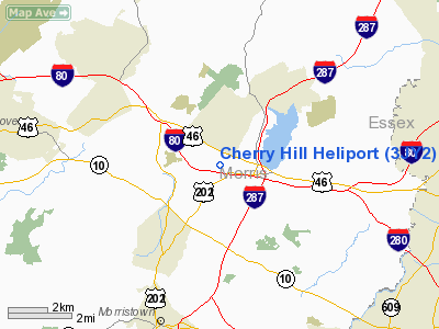
| From nearest city: | 1 nautical miles NW of Parsippany-troy Hills, NJ |
| Location: | Morris County, NJ |
| Magnetic Variation: | () |
Owner & Manager
| Ownership: | Privately owned |
| Owner: | Ti Parsippany Inc.
HAROLD ROSEN, PRESIDENT, PHONE 212-522-1309. |
| Address: | 260 Cherry Hill Rd
Parsippany, NJ 07054 |
| Phone number: | 973-257-7656 |
| Manager: | Fred Horwood
DIRECTOR OF FACILITIES. |
| Address: | Time Inc., 1271 Avenue Of The Americas
New York, NY 10020 |
| Phone number: | 212-522-1212 |
Airport Operations and Facilities
| Airport Use: | Private |
| Wind indicator: | Yes |
| Control Tower: | No |
| Lighting Schedule: | RDO CTL
ACTIVATE PERIMETER LGTS ON FREQ 123.075. |
| Sectional chart: | New York |
| Region: | AEA - Eastern |
| Boundary ARTCC: | ZNY - New York |
| Tie-in FSS: | MIV - Millville |
| FSS Toll Free: | 1-800-WX-BRIEF |
Airport Communications
Runway Information
Helipad H1
| Dimension: | 50 x 50 ft / 15.2 x 15.2 m |
| Surface: | ASPH, |
| |
Runway H1 |
Runway |
| Traffic Pattern: | Left | Left |
|
Radio Navigation Aids
| ID |
Type |
Name |
Ch |
Freq |
Var |
Dist |
| EWR | FAN MARKER | Maryann | | | 11W | 15.4 nm |
| SKU | FAN MARKER | Stanwyck | | | 12W | 43.4 nm |
| CAT | NDB | Chatham | | 254.00 | 11W | 7.8 nm |
| PNJ | NDB | Paterson | | 347.00 | 12W | 14.0 nm |
| OGY | NDB | Bridge | | 414.00 | 12W | 31.3 nm |
| SW | NDB | Neely | | 335.00 | 14W | 38.2 nm |
| SKU | NDB | Stanwyck | | 261.00 | 12W | 43.4 nm |
| DYL | NDB | Doylestown | | 237.00 | 10W | 44.6 nm |
| UKT | NDB | Quakertown | | 208.00 | 12W | 47.3 nm |
| PO | NDB | Meier | | 403.00 | 12W | 47.6 nm |
| BBN | NDB | Babylon | | 275.00 | 14W | 49.6 nm |
| NEL | NDB | Lakehurst | | 396.00 | 13W | 49.9 nm |
| NEL | UHF/NDB | Lakehurst | | 274.80 | 13W | 49.9 nm |
| TEB | VOR/DME | Teterboro | 021X | 108.40 | 11W | 17.4 nm |
| BWZ | VOR/DME | Broadway | 089X | 114.20 | 11W | 17.8 nm |
| STW | VOR/DME | Stillwater | 033X | 109.60 | 11W | 20.7 nm |
| SBJ | VOR/DME | Solberg | 076X | 112.90 | 10W | 22.0 nm |
| LGA | VOR/DME | La Guardia | 078X | 113.10 | 12W | 26.2 nm |
| CRI | VOR/DME | Canarsie | 070X | 112.30 | 11W | 29.4 nm |
| HUO | VOR/DME | Huguenot | 108X | 116.10 | 11W | 33.1 nm |
| JFK | VOR/DME | Kennedy | 106X | 115.90 | 12W | 33.8 nm |
| COL | VOR/DME | Colts Neck | 101X | 115.40 | 11W | 36.0 nm |
| ARD | VOR/DME | Yardley | 019X | 108.20 | 10W | 42.7 nm |
| CMK | VOR/DME | Carmel | 113X | 116.60 | 12W | 46.2 nm |
| CKZ | VOR/DME | Pennridge | 025Y | 108.85 | 12W | 48.2 nm |
| SAX | VORTAC | Sparta | 104X | 115.70 | 11W | 12.6 nm |
| RBV | VORTAC | Robbinsville | 085X | 113.80 | 10W | 40.2 nm |
| FJC | VORTAC | Allentown | 122X | 117.50 | 10W | 46.8 nm |
| JFK | VOT | Kennedy | | 115.10 | | 33.4 nm |
Remarks
- PRVDD VFR OPNS, PVT USE, AREA IS MARKED AND WIND INDICATOR MAINTAINED.
Images and information placed above are from
http://www.airport-data.com/airport/3JY2/
We thank them for the data!
|
|


