|
|
Central Jersey Rgnl Airport |
| Central Jersey Regional Airport |
 |
| IATA: JVI – ICAO: none – FAA LID: 47N |
| Summary |
| Airport type |
Public |
| Owner |
Central Jersey Airport Services |
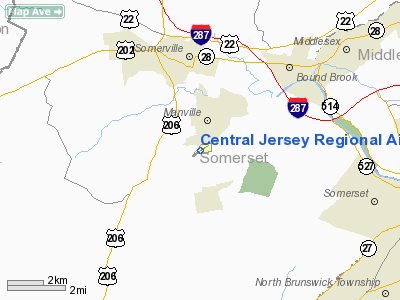
| Location |
Manville, New Jersey |
| Elevation AMSL |
86 ft / 26 m |
| Coordinates |
40°31′28″N 074°35′54″W / 40.52444°N 74.59833°W / 40.52444; -74.59833 |
| Website |
www.CentralJerseyAirport.com |
| Runways |
| Direction |
Length |
Surface |
| ft |
m |
| 7/25 |
3,509 |
1,070 |
Asphalt |
| Source: Federal Aviation Administration |
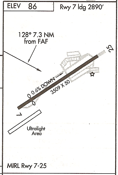
Central Jersey Regional Airport (IATA: JVI, FAA LID: 47N), formerly known as Kupper Airport, is a privately owned, public use airport in Somerset County, New Jersey, located in Hillsborough Township on the border with Manville. On the airport property is the Van Nest - Weston Burying Ground, a small cemetery. Facilities
Runways
Central Jersey Regional Airport covers an area of 119 acres (48 ha) which contains one runway:
- Runway 7/25: 3,509 x 50 ft (1,070 x 15 m), Surface: Asphalt
On field
- Fuel: 100LL
- Parking
- Aircraft service
- Aircraft rental
- Pilot lounge and supplies
- Pizza & Pasta Restaurant
Off field
- Ramada Inn 4 mi 732-560-9880
- Double Tree Hotel 732-469-2600
- Car rental Dollar 732-563-9800
The above content comes from Wikipedia and is published under free licenses – click here to read more.
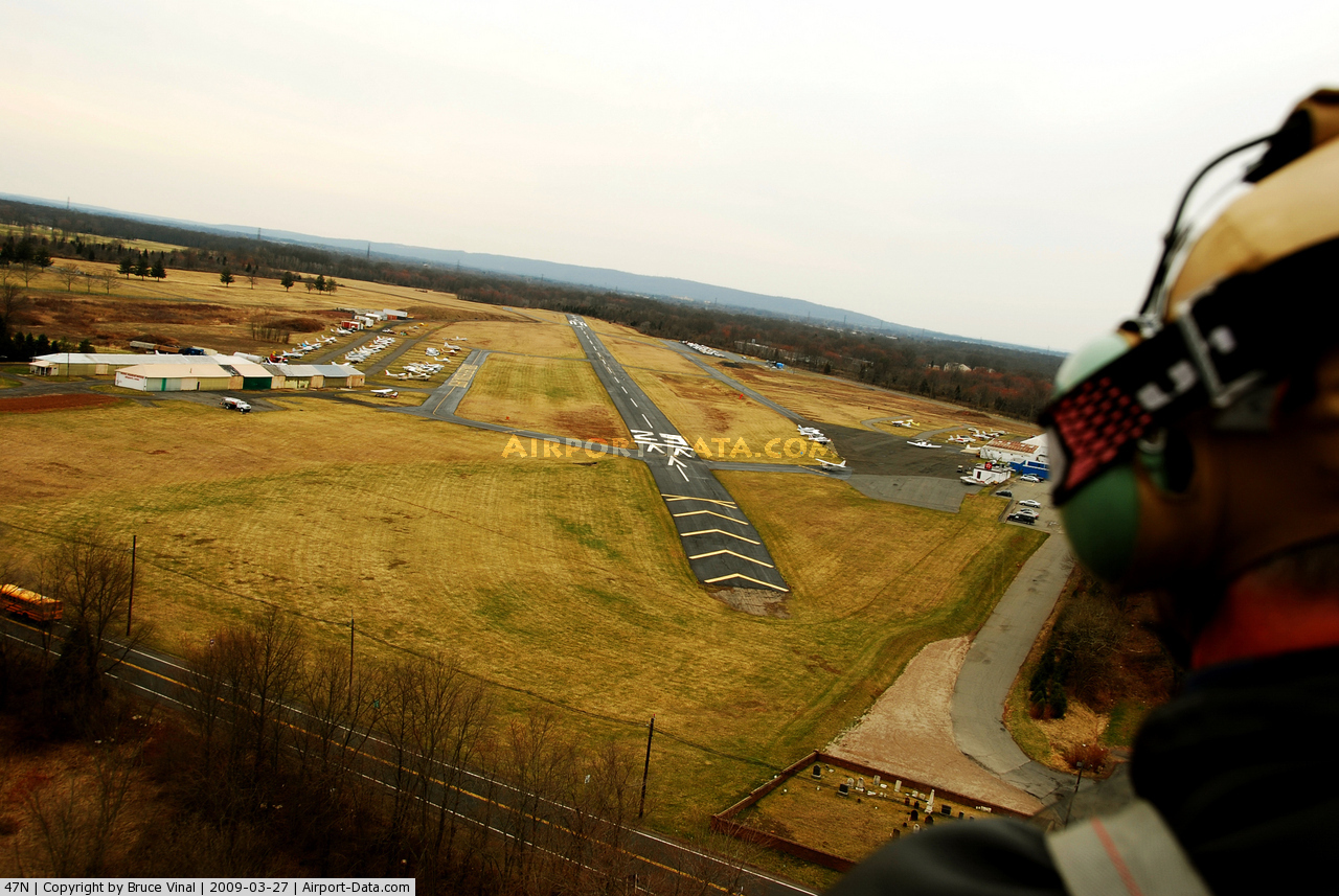
 |
(Click on the photo to enlarge) |
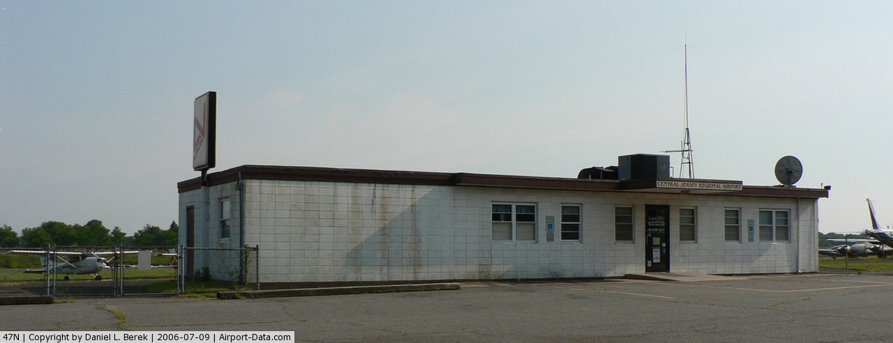
 |
(Click on the photo to enlarge) |
Location & QuickFacts
| FAA Information Effective: | 2008-09-25 |
| Airport Identifier: | 47N |
| Airport Status: | Operational |
| Longitude/Latitude: | 074-35-54.2110W/40-31-27.7830N
-74.598392/40.524384 (Estimated) |
| Elevation: | 86 ft / 26.21 m (Surveyed) |
| Land: | 119 acres |
| From nearest city: | 1 nautical miles S of Manville, NJ |
| Location: | Somerset County, NJ |
| Magnetic Variation: | 13W (2000) |
Owner & Manager
| Ownership: | Privately owned |
| Owner: | Central Jersey Airport Svcs Llc |
| Address: | Po Box 358
Manville, NJ 08835 |
| Phone number: | 908-526-2822 |
| Manager: | Greg Burchette |
| Address: | Po Box 358
Manville, NJ 08835 |
| Phone number: | 908-526-2822 |
Airport Operations and Facilities
| Airport Use: | Open to public |
| Wind indicator: | Yes |
| Segmented Circle: | No |
| Control Tower: | No |
| Lighting Schedule: | DUSK-DAWN |
| Beacon Color: | Clear-Green (lighted land airport) |
| Landing fee charge: | No |
| Sectional chart: | New York |
| Region: | AEA - Eastern |
| Traffic Pattern Alt: | 1000 ft |
| Boundary ARTCC: | ZNY - New York |
| Tie-in FSS: | MIV - Millville |
| FSS on Airport: | No |
| FSS Toll Free: | 1-800-WX-BRIEF |
| NOTAMs Facility: | MIV (NOTAM-d service avaliable) |
| Federal Agreements: | NGY |
Airport Communications
| CTAF: | 122.700 |
| Unicom: | 122.700 |
Airport Services
| Fuel available: | 100LL |
| Airframe Repair: | MAJOR |
| Power Plant Repair: | MAJOR |
| Bottled Oxygen: | NONE |
| Bulk Oxygen: | NONE |
Runway Information
Runway 07/25
| Dimension: | 3509 x 50 ft / 1069.5 x 15.2 m
PVED OVERRUN APP END RWY 25, 216 FT LONG. UNUSABLE, STEEP SLOPE. |
| Surface: | ASPH, Good Condition |
| Weight Limit: | Single wheel: 30000 lbs. |
| Edge Lights: | Non-standard lighting system
FIRST 272 FT RY 25 UNLGTD. RY 25 END LTS LCTD 150 FT PRIOR TO END OF PAVEMENT, ONLY ONE LT ON EACH SIDE. RY 07 THLD LTS LCTD 37 FT PRIOR TO DISPLACED THLD, 585 FT FM PAVEMENT END. LAST HALF OF RY LTS DO NOT HAVE SPLIT CLEAR/AMBER LENSES. |
| |
Runway 07 |
Runway 25 |
| Longitude: | 074-36-13.0660W | 074-35-35.3570W |
| Latitude: | 40-31-18.1090N | 40-31-37.4560N |
| Elevation: | 86.00 ft | 64.00 ft |
| Alignment: | 56 | 127 |
| Traffic Pattern: | Left | Left |
| Markings: | Non-precision instrument, Good Condition | Basic, Good Condition |
| Displaced threshold: | 619.00 ft | 0.00 ft |
| Obstruction: | 23 ft rr, 200.0 ft from runway | 31 ft trees, 558.0 ft from runway, 11:1 slope to clear
+42 FT TREE, 128 FT FM RWY END, 220 FT R. |
|
Radio Navigation Aids
| ID |
Type |
Name |
Ch |
Freq |
Var |
Dist |
| EWR | FAN MARKER | Maryann | | | 11W | 21.6 nm |
| CAT | NDB | Chatham | | 254.00 | 11W | 15.1 nm |
| DYL | NDB | Doylestown | | 237.00 | 10W | 26.5 nm |
| NEL | NDB | Lakehurst | | 396.00 | 13W | 31.2 nm |
| NXX | NDB | Willow Grove | | 388.00 | 12W | 32.1 nm |
| UKT | NDB | Quakertown | | 208.00 | 12W | 32.5 nm |
| PNJ | NDB | Paterson | | 347.00 | 12W | 32.5 nm |
| OGY | NDB | Bridge | | 414.00 | 12W | 32.8 nm |
| ING | NDB | Ambler | | 275.00 | 11W | 39.5 nm |
| NEL | TACAN | Lakehurst | 055X | | 11W | 31.4 nm |
| NXX | TACAN | Willow Grove | 061X | | 10W | 32.0 nm |
| NEL | UHF/NDB | Lakehurst | | 274.80 | 13W | 31.2 nm |
| PNE | VOR | North Philadelphia | | 112.00 | 10W | 32.6 nm |
| SBJ | VOR/DME | Solberg | 076X | 112.90 | 10W | 7.4 nm |
| BWZ | VOR/DME | Broadway | 089X | 114.20 | 11W | 19.4 nm |
| ARD | VOR/DME | Yardley | 019X | 108.20 | 10W | 21.6 nm |
| COL | VOR/DME | Colts Neck | 101X | 115.40 | 11W | 23.8 nm |
| STW | VOR/DME | Stillwater | 033X | 109.60 | 11W | 30.9 nm |
| TEB | VOR/DME | Teterboro | 021X | 108.40 | 11W | 31.3 nm |
| CRI | VOR/DME | Canarsie | 070X | 112.30 | 11W | 32.6 nm |
| CKZ | VOR/DME | Pennridge | 025Y | 108.85 | 12W | 32.6 nm |
| LGA | VOR/DME | La Guardia | 078X | 113.10 | 12W | 36.5 nm |
| JFK | VOR/DME | Kennedy | 106X | 115.90 | 12W | 38.3 nm |
| ETX | VOR/DME | East Texas | 039X | 110.20 | 09W | 49.7 nm |
| RBV | VORTAC | Robbinsville | 085X | 113.80 | 10W | 19.9 nm |
| GXU | VORTAC | Mc Guire | 043X | 110.60 | 11W | 30.9 nm |
| SAX | VORTAC | Sparta | 104X | 115.70 | 11W | 32.8 nm |
| FJC | VORTAC | Allentown | 122X | 117.50 | 10W | 40.9 nm |
| CYN | VORTAC | Coyle | 081X | 113.40 | 10W | 43.2 nm |
| PTW | VORTAC | Pottstown | 112X | 116.50 | 09W | 47.6 nm |
| JFK | VOT | Kennedy | | 115.10 | | 38.0 nm |
| PHL | VOT | Philadelphia Intl | | 109.80 | | 49.3 nm |
Remarks
- HVY ULTRALIGHT ACTIVITY MAY-OCT S OF RWY 07/25.
- GCO AVBL ON FREQ 121.725 THRU MIV FSS.
- BANNER TOW OPERATIONS SW OF RUNWAY 07
- EXISTED PRIOR TO 19599
Images and information placed above are from
http://www.airport-data.com/airport/47N/
We thank them for the data!
| General Info
|
| Country |
United States
|
| State |
NEW JERSEY
|
| FAA ID |
47N
|
| Latitude |
40-31-27.783N
|
| Longitude |
074-35-54.211W
|
| Elevation |
86 feet
|
| Near City |
MANVILLE
|
We don't guarantee the information is fresh and accurate. The data may
be wrong or outdated.
For more up-to-date information please refer to other sources.
|
|