 |
|
Coordinates: 39°46′42.314″N 074°56′52.094″W / 39.77842056°N 74.94780389°W / 39.77842056; -74.94780389
| Camden County Airport |
| IATA: none – ICAO: none – FAA LID: 19N |
| Summary |
| Airport type |
Public use |
| Owner |
Albion Airport, Inc. |
| Operator |
Karl Kleinberg |
| Serves |
Berlin, New Jersey |
| Location |
Camden County, New Jersey |
| Elevation AMSL |
150 ft / 46 m |
| Runways |
| Direction |
Length |
Surface |
| ft |
m |
| 5/23 |
3,102 |
945 |
Asphalt |
| Statistics (2008) |
| Aircraft operations |
3,182 |
| Based aircraft |
28 |
| Source: Federal Aviation Administration |
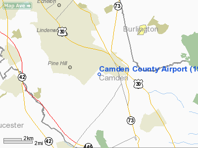
Camden County Airport (FAA LID: 19N) is a public-use airport located one nautical mile (1.852 km) southwest of the central business district of the borough of Berlin in Camden County, New Jersey, United States. The airport is privately owned.
The above content comes from Wikipedia and is published under free licenses – click here to read more.
Location & QuickFacts
| FAA Information Effective: | 2008-09-25 |
| Airport Identifier: | 19N |
| Airport Status: | Operational |
| Longitude/Latitude: | 074-56-52.0940W/39-46-42.3140N
-74.947804/39.778421 (Estimated) |
| Elevation: | 150 ft / 45.72 m (Estimated) |
| Land: | 75 acres |
| From nearest city: | 1 nautical miles SW of Berlin, NJ |
| Location: | Camden County, NJ |
| Magnetic Variation: | 12W (2000) |
Owner & Manager
| Ownership: | Privately owned |
| Owner: | Albion Airport, Inc. |
| Address: | 817 Watsontown Rd.
Berlin, NJ 08009 |
| Phone number: | 856-767-1233 |
| Manager: | Karl Kleinberg |
| Address: | 817 Watsontown Rd
Berlin, NJ 08009 |
| Phone number: | 856-767-1233 |
Airport Operations and Facilities
| Airport Use: | Open to public |
| Wind indicator: | Yes |
| Segmented Circle: | No |
| Control Tower: | No |
| Lighting Schedule: | DUSK-DAWN
ACTVT MIRL RYS 05/23, REIL RYS 05 & 23, PLASI RY 23, BCN - CTAF. |
| Beacon Color: | Clear-Green (lighted land airport) |
| Landing fee charge: | No |
| Sectional chart: | Washington |
| Region: | AEA - Eastern |
| Traffic Pattern Alt: | 1000 ft |
| Boundary ARTCC: | ZDC - Washington |
| Responsible ARTCC: | ZNY - New York |
| Tie-in FSS: | MIV - Millville |
| FSS on Airport: | No |
| FSS Toll Free: | 1-800-WX-BRIEF |
| NOTAMs Facility: | MIV (NOTAM-d service avaliable) |
| Federal Agreements: | N |
Airport Communications
| CTAF: | 123.000 |
| Unicom: | 123.000 |
Airport Services
| Fuel available: | 100LLA |
| Airframe Repair: | MAJOR |
| Power Plant Repair: | MAJOR |
Runway Information
Runway 05/23
| Dimension: | 3102 x 45 ft / 945.5 x 13.7 m |
| Surface: | ASPH, Good Condition |
| Edge Lights: | Medium |
| |
Runway 05 |
Runway 23 |
| Longitude: | 074-57-04.3290W | 074-56-39.8980W |
| Latitude: | 39-46-30.2530N | 39-46-54.4250N |
| Elevation: | 150.00 ft | 141.00 ft |
| Alignment: | 38 | 127 |
| Traffic Pattern: | Left | Left |
| Markings: | Non-precision instrument, Fair Condition | Non-precision instrument, Fair Condition |
| Displaced threshold: | 744.00 ft | 240.00 ft |
| VASI: | | pulsating/steady burning on right side |
| Runway End Identifier: | Yes | Yes
REIL RY 23 OTS INDEFLY. |
| Obstruction: | 38 ft tree, 211.0 ft from runway, 68 ft left of centerline
+74 FT TREE, DIST 16 FT, 82 FT L, 0:1 BASED ON DSPLCD THLD.
+28 FT POLE, 7 FT FM RY END, 74 FT L. | 78 ft tree, 253.0 ft from runway, 196 ft left of centerline
+47 FT TREE, DIST 6 FT, 140 FT R, 0:1 BASED ON DSPLCD THLD.
+44 FT TREE, 37 FT FM RY END, 206 FT R. |
|
Radio Navigation Aids
| ID |
Type |
Name |
Ch |
Freq |
Var |
Dist |
| RNB | NDB | Rainbow | | 363.00 | 11W | 23.3 nm |
| ING | NDB | Ambler | | 275.00 | 11W | 26.0 nm |
| NXX | NDB | Willow Grove | | 388.00 | 12W | 26.3 nm |
| NEL | NDB | Lakehurst | | 396.00 | 13W | 32.4 nm |
| DYL | NDB | Doylestown | | 237.00 | 10W | 34.4 nm |
| UKT | NDB | Quakertown | | 208.00 | 12W | 42.0 nm |
| NXX | TACAN | Willow Grove | 061X | | 10W | 26.6 nm |
| NEL | TACAN | Lakehurst | 055X | | 11W | 31.5 nm |
| DOV | TACAN | Dover | 037X | | 09W | 45.7 nm |
| NEL | UHF/NDB | Lakehurst | | 274.80 | 13W | 32.4 nm |
| PNE | VOR | North Philadelphia | | 112.00 | 10W | 18.5 nm |
| ARD | VOR/DME | Yardley | 019X | 108.20 | 10W | 28.6 nm |
| CKZ | VOR/DME | Pennridge | 025Y | 108.85 | 12W | 40.0 nm |
| COL | VOR/DME | Colts Neck | 101X | 115.40 | 11W | 48.4 nm |
| SBJ | VOR/DME | Solberg | 076X | 112.90 | 10W | 49.3 nm |
| VCN | VORTAC | Cedar Lake | 099X | 115.20 | 10W | 14.5 nm |
| OOD | VORTAC | Woodstown | 075X | 112.80 | 10W | 18.5 nm |
| GXU | VORTAC | Mc Guire | 043X | 110.60 | 11W | 21.3 nm |
| CYN | VORTAC | Coyle | 081X | 113.40 | 10W | 24.0 nm |
| ACY | VORTAC | Atlantic City | 023X | 108.60 | 10W | 25.9 nm |
| DQO | VORTAC | Dupont | 087X | 114.00 | 10W | 31.1 nm |
| RBV | VORTAC | Robbinsville | 085X | 113.80 | 10W | 32.9 nm |
| MXE | VORTAC | Modena | 079X | 113.20 | 09W | 34.4 nm |
| PTW | VORTAC | Pottstown | 112X | 116.50 | 09W | 38.8 nm |
| SIE | VORTAC | Sea Isle | 095X | 114.80 | 09W | 41.6 nm |
| ENO | VORTAC | Smyrna | 051X | 111.40 | 09W | 42.1 nm |
| PHL | VOT | Philadelphia Intl | | 109.80 | | 14.8 nm |
Images and information placed above are from
http://www.airport-data.com/airport/19N/
We thank them for the data!
| General Info
|
| Country |
United States
|
| State |
NEW JERSEY
|
| FAA ID |
19N
|
| Latitude |
39-46-42.314N
|
| Longitude |
074-56-52.094W
|
| Elevation |
150 feet
|
| Near City |
BERLIN
|
We don't guarantee the information is fresh and accurate. The data may
be wrong or outdated.
For more up-to-date information please refer to other sources.
|
|


