 |
|
Coordinates: 39°28′23.414″N 075°11′06.665″W / 39.47317056°N 75.18518472°W / 39.47317056; -75.18518472
| Bucks Airport |
| IATA: none – ICAO: none – FAA LID: 00N |
| Summary |
| Airport type |
Public use |
| Owner/Operator |
J. Di Orio |
| Serves |
Bridgeton, New Jersey |
| Location |
Cumberland County, New Jersey |
| Elevation AMSL |
105 ft / 35 m |
| Runways |
| Direction |
Length |
Surface |
| ft |
m |
| 18/36 |
1,900 |
579 |
Turf |
| Statistics (2008) |
| Aircraft operations |
1,200 |
| Based aircraft |
21 |
| Source: Federal Aviation Administration |
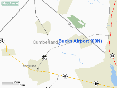
Bucks Airport (FAA LID: 00N) is a public-use airport located three nautical miles (5.556 km) northeast of the central business district of the city of Bridgeton in Cumberland County, New Jersey, United States, The airport is privately owned.
The above content comes from Wikipedia and is published under free licenses – click here to read more.
Location & QuickFacts
| FAA Information Effective: | 2008-09-25 |
| Airport Identifier: | 00N |
| Airport Status: | Operational |
| Longitude/Latitude: | 075-11-06.6650W/39-28-23.4140N
-75.185185/39.473171 (Estimated) |
| Elevation: | 105 ft / 32.00 m (Estimated) |
| Land: | 63 acres |
| From nearest city: | 3 nautical miles NE of Bridgeton, NJ |
| Location: | Cumberland County, NJ |
| Magnetic Variation: | 11W (1985) |
Owner & Manager
| Ownership: | Privately owned |
| Owner: | J. Di Orio |
| Address: | 14 Briarwood La
Bridgeton, NJ 08302 |
| Phone number: | 856-455-3990 |
| Manager: | J. Di Orio |
| Address: | 14 Briarwood La
Bridgeton, NJ 08302 |
| Phone number: | 856-455-3990 |
Airport Operations and Facilities
| Airport Use: | Open to public |
| Wind indicator: | Yes |
| Segmented Circle: | No |
| Control Tower: | No |
| Lighting Schedule: | PHONE REQ
FOR LIRL RY 18/36 CALL 856-455-3990. |
| Landing fee charge: | No |
| Sectional chart: | Washington |
| Region: | AEA - Eastern |
| Traffic Pattern Alt: | 900 ft |
| Boundary ARTCC: | ZDC - Washington |
| Tie-in FSS: | MIV - Millville |
| FSS on Airport: | No |
| FSS Toll Free: | 1-800-WX-BRIEF |
| NOTAMs Facility: | MIV (NOTAM-d service avaliable) |
Airport Communications
Airport Services
| Airframe Repair: | NONE |
| Power Plant Repair: | NONE |
| Bottled Oxygen: | NONE |
| Bulk Oxygen: | NONE |
Runway Information
Runway 18/36
| Dimension: | 1900 x 150 ft / 579.1 x 45.7 m |
| Surface: | TURF, Good Condition |
| Edge Lights: | Low |
| |
Runway 18 |
Runway 36 |
| Traffic Pattern: | Left | Left |
| Obstruction: | 27 ft tree, 15.0 ft from runway, 120 ft right of centerline | 38 ft tree, 135.0 ft from runway, 90 ft right of centerline, 3:1 slope to clear |
|
Radio Navigation Aids
| ID |
Type |
Name |
Ch |
Freq |
Var |
Dist |
| RNB | NDB | Rainbow | | 363.00 | 11W | 4.0 nm |
| ING | NDB | Ambler | | 275.00 | 11W | 39.5 nm |
| APG | NDB | Aberdeen | | 349.00 | 11W | 42.9 nm |
| NXX | NDB | Willow Grove | | 388.00 | 12W | 43.1 nm |
| DOV | TACAN | Dover | 037X | | 09W | 24.3 nm |
| NXX | TACAN | Willow Grove | 061X | | 10W | 43.4 nm |
| PNE | VOR | North Philadelphia | | 112.00 | 10W | 37.5 nm |
| ATR | VOR/DME | Waterloo | 073X | 112.60 | 09W | 39.9 nm |
| PPM | VOR/DME | Phillips | 021X | 108.40 | 09W | 45.7 nm |
| ARD | VOR/DME | Yardley | 019X | 108.20 | 10W | 48.6 nm |
| VCN | VORTAC | Cedar Lake | 099X | 115.20 | 10W | 10.8 nm |
| OOD | VORTAC | Woodstown | 075X | 112.80 | 10W | 11.2 nm |
| ENO | VORTAC | Smyrna | 051X | 111.40 | 09W | 21.1 nm |
| DQO | VORTAC | Dupont | 087X | 114.00 | 10W | 23.1 nm |
| ACY | VORTAC | Atlantic City | 023X | 108.60 | 10W | 28.3 nm |
| SIE | VORTAC | Sea Isle | 095X | 114.80 | 09W | 28.9 nm |
| MXE | VORTAC | Modena | 079X | 113.20 | 09W | 34.9 nm |
| CYN | VORTAC | Coyle | 081X | 113.40 | 10W | 40.6 nm |
| GXU | VORTAC | Mc Guire | 043X | 110.60 | 11W | 42.2 nm |
| PTW | VORTAC | Pottstown | 112X | 116.50 | 09W | 48.2 nm |
| PHL | VOT | Philadelphia Intl | | 109.80 | | 24.0 nm |
Remarks
- ARPT CLSD TO ALL TRANSIENT ACFT JAN 1 - APR 1 BECAUSE OF SOFT RY CONDITIONS; FOR PPR CALL 856-455-3990.
- RWY 36 +55 TO +65 FT TREES, 500 FT SHORT OF THLD, 40-75 FT R. +46 FT MKD PLINE, 330 FT SHORT OF THLD.
- ARPT EXISTED PRIOR TO MAY 15 1959.
Images and information placed above are from
http://www.airport-data.com/airport/00N/
We thank them for the data!
| General Info
|
| Country |
United States
|
| State |
NEW JERSEY
|
| FAA ID |
00N
|
| Latitude |
39-28-23.414N
|
| Longitude |
075-11-06.665W
|
| Elevation |
105 feet
|
| Near City |
BRIDGETON
|
We don't guarantee the information is fresh and accurate. The data may
be wrong or outdated.
For more up-to-date information please refer to other sources.
|
|


