 |
|
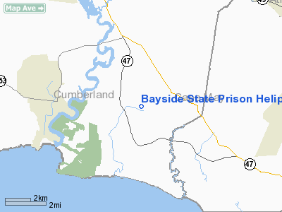
Bayside State Prison Heliport |
Location & QuickFacts
| FAA Information Effective: | 2008-09-25 |
| Airport Identifier: | JY32 |
| Airport Status: | Operational |
| Longitude/Latitude: | 074-57-07.0000W/39-14-30.0000N
-74.951944/39.241667 (Estimated) |
| Elevation: | 15 ft / 4.57 m (Estimated) |
| Land: | 0 acres |
| From nearest city: | 2 nautical miles SE of Leesburg, NJ |
| Location: | Cumberland County, NJ |
| Magnetic Variation: | 12W (2000) |
Owner & Manager
| Ownership: | Publicly owned |
| Owner: | Bayside State Prison |
| Address: | 4293 Route 47
Leesburg, NJ 08327 |
| Phone number: | 856-785-0040 |
| Manager: | Fred Vineyard, Asst Engr. |
| Address: | Bayside State Prison, Route 47
Leesburg, NJ 08327 |
| Phone number: | 856-785-0040 |
Airport Operations and Facilities
| Airport Use: | Private |
| Wind indicator: | Yes |
| Segmented Circle: | No |
| Control Tower: | No |
| Lighting Schedule: | DUSK-DAWN |
| Sectional chart: | Washington |
| Region: | AEA - Eastern |
| Boundary ARTCC: | ZDC - Washington |
| Tie-in FSS: | MIV - Millville |
| FSS Toll Free: | 1-800-WX-BRIEF |
Runway Information
Helipad H1
| Dimension: | 100 x 120 ft / 30.5 x 36.6 m |
| Surface: | CONC, Good Condition |
| |
Runway H1 |
Runway |
| Traffic Pattern: | Left | Left |
|
Radio Navigation Aids
| ID |
Type |
Name |
Ch |
Freq |
Var |
Dist |
| RNB | NDB | Rainbow | | 363.00 | 11W | 13.6 nm |
| DOV | TACAN | Dover | 037X | | 09W | 24.9 nm |
| ATR | VOR/DME | Waterloo | 073X | 112.60 | 09W | 28.6 nm |
| SIE | VORTAC | Sea Isle | 095X | 114.80 | 09W | 11.3 nm |
| VCN | VORTAC | Cedar Lake | 099X | 115.20 | 10W | 17.8 nm |
| ACY | VORTAC | Atlantic City | 023X | 108.60 | 10W | 21.7 nm |
| ENO | VORTAC | Smyrna | 051X | 111.40 | 09W | 26.3 nm |
| OOD | VORTAC | Woodstown | 075X | 112.80 | 10W | 28.8 nm |
| DQO | VORTAC | Dupont | 087X | 114.00 | 10W | 40.2 nm |
| CYN | VORTAC | Coyle | 081X | 113.40 | 10W | 42.2 nm |
| GXU | VORTAC | Mc Guire | 043X | 110.60 | 11W | 49.0 nm |
| PHL | VOT | Philadelphia Intl | | 109.80 | | 40.2 nm |
Remarks
- PRVDD A CLEAR INGRESS/EGRESS FOR A 8:1 SLOPE AND APPROPRIATE MARKINGS AND A LGTD WIND SOCK.
Images and information placed above are from
http://www.airport-data.com/airport/JY32/
We thank them for the data!
| General Info
|
| Country |
United States
|
| State |
NEW JERSEY
|
| FAA ID |
JY32
|
| Latitude |
39-14-30.000N
|
| Longitude |
074-57-07.000W
|
| Elevation |
15 feet
|
| Near City |
LEESBURG
|
We don't guarantee the information is fresh and accurate. The data may
be wrong or outdated.
For more up-to-date information please refer to other sources.
|
|


