 |
|
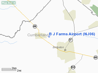
Location & QuickFacts
| FAA Information Effective: | 2008-09-25 |
| Airport Identifier: | NJ06 |
| Airport Status: | Operational |
| Longitude/Latitude: | 075-16-23.6820W/39-27-27.4120N
-75.273245/39.457614 (Estimated) |
| Elevation: | 100 ft / 30.48 m (Estimated) |
| Land: | 0 acres |
| From nearest city: | 3 nautical miles E of Shiloh, NJ |
| Location: | Cumberland County, NJ |
| Magnetic Variation: | 11W (1990) |
Owner & Manager
| Ownership: | Privately owned |
| Owner: | Frank Bartinger |
| Address: | 50 Minches Corner Road
Bridgeton, NJ 08302 |
| Phone number: | 609-451-7005 |
| Manager: | Frank Bartinger |
| Address: | 50 Minches Corner Road
Bridgeton, NJ 08302 |
| Phone number: | 609-451-7005 |
Airport Operations and Facilities
| Airport Use: | Private |
| Wind indicator: | Yes |
| Segmented Circle: | No |
| Control Tower: | No |
| Sectional chart: | Washington |
| Region: | AEA - Eastern |
| Boundary ARTCC: | ZDC - Washington |
| Tie-in FSS: | MIV - Millville |
| FSS Toll Free: | 1-800-WX-BRIEF |
Runway Information
Runway 09/27
| Dimension: | 1500 x 50 ft / 457.2 x 15.2 m |
| Surface: | TURF, |
| |
Runway 09 |
Runway 27 |
| Traffic Pattern: | Left | Left |
| Displaced threshold: | 0.00 ft | 300.00 ft |
| Obstruction: | | 15 ft plines, 200.0 ft from runway |
|
Radio Navigation Aids
| ID |
Type |
Name |
Ch |
Freq |
Var |
Dist |
| RNB | NDB | Rainbow | | 363.00 | 11W | 6.8 nm |
| APG | NDB | Aberdeen | | 349.00 | 11W | 38.9 nm |
| ING | NDB | Ambler | | 275.00 | 11W | 40.2 nm |
| NXX | NDB | Willow Grove | | 388.00 | 12W | 44.4 nm |
| DOV | TACAN | Dover | 037X | | 09W | 21.5 nm |
| NXX | TACAN | Willow Grove | 061X | | 10W | 44.7 nm |
| PNE | VOR | North Philadelphia | | 112.00 | 10W | 39.5 nm |
| ATR | VOR/DME | Waterloo | 073X | 112.60 | 09W | 39.0 nm |
| PPM | VOR/DME | Phillips | 021X | 108.40 | 09W | 41.7 nm |
| OOD | VORTAC | Woodstown | 075X | 112.80 | 10W | 10.8 nm |
| VCN | VORTAC | Cedar Lake | 099X | 115.20 | 10W | 15.0 nm |
| ENO | VORTAC | Smyrna | 051X | 111.40 | 09W | 17.7 nm |
| DQO | VORTAC | Dupont | 087X | 114.00 | 10W | 20.4 nm |
| SIE | VORTAC | Sea Isle | 095X | 114.80 | 09W | 31.0 nm |
| ACY | VORTAC | Atlantic City | 023X | 108.60 | 10W | 32.3 nm |
| MXE | VORTAC | Modena | 079X | 113.20 | 09W | 33.2 nm |
| CYN | VORTAC | Coyle | 081X | 113.40 | 10W | 44.6 nm |
| GXU | VORTAC | Mc Guire | 043X | 110.60 | 11W | 45.6 nm |
| PTW | VORTAC | Pottstown | 112X | 116.50 | 09W | 47.8 nm |
| PHL | VOT | Philadelphia Intl | | 109.80 | | 24.8 nm |
Remarks
- (E111A) 22 FT TREES AT W END & N SHOULD BE 279 FT FM RY CL & HOUSE N OF E END OF RY SHOULD BE 223 FT FM RY.
- PRVDD CTC IS MADE WITH THE PHILADELPHIA TWR ON 118.35 (215) 492-4123 PRIOR TO OPS; COORD OPS WITH WIDE SKY & BUCKS ARPT; & RY 27 THR IS DSPLCD AN ADDITIONAL 100 FT (TOTAL OF 300 FT) TO PRVDD A 20:1 APCH.
Images and information placed above are from
http://www.airport-data.com/airport/NJ06/
We thank them for the data!
| General Info
|
| Country |
United States
|
| State |
NEW JERSEY
|
| FAA ID |
NJ06
|
| Latitude |
39-27-27.412N
|
| Longitude |
075-16-23.682W
|
| Elevation |
100 feet
|
| Near City |
SHILOH
|
We don't guarantee the information is fresh and accurate. The data may
be wrong or outdated.
For more up-to-date information please refer to other sources.
|
|


