|
 |
|
||||
|
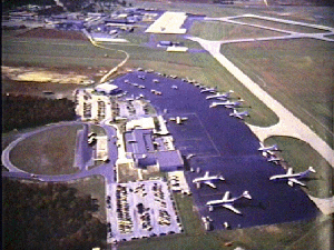
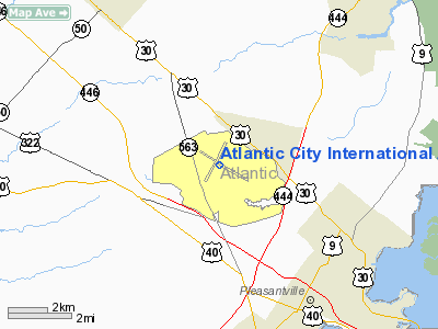
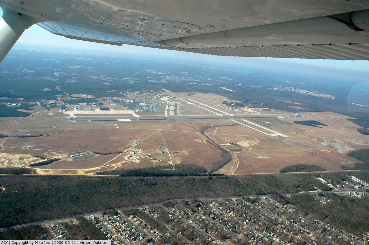
Atlantic City International Airport (IATA: ACY, ICAO: KACY, FAA LID: ACY) is a joint civil-military public airport located nine nautical miles (17 km) northwest of the central business district of Atlantic City, in Atlantic County, New Jersey. Situated in Pomona, it is the major component of a national aviation area that lies on portions of three municipalities: Egg Harbor Township, Galloway Township, and Hamilton Township. The airport is accessible via Exit 9 on the Atlantic City Expressway. The facility is owned and operated by the South Jersey Transportation Authority. The facility also serves as a base for the New Jersey Air National Guard's 177th Fighter Wing operating the F-16C/D Fighting Falcon, and the United States Coast Guard's Coast Guard Air Station Atlantic City operating the HH-65 Dolphin. The airport is adjacent to the William J. Hughes FAA Technical Center, a major research and testing hub for the Federal Aviation Administration, and a training center for the Federal Air Marshal Service. It is also an abort landing site for the Space Shuttle. The airport is served by Spirit Airlines and AirTran Airways. Additionally, Harrah's Entertainment is offering service to select destinations east of the Mississippi River via its Total Rewards Air. This service is being offered as a scheduled charter and only during the summer months. Flights are offered through Gold Transportation on a Sky King or Pace Airlines 737, or similar aircraft. The South Jersey Transportation Authority has outlined plans for massive terminal expansions (on top of current initiatives) which might be necessary if more air carriers wish to serve the airport. Total passenger traffic at the airport in 2010 was 947,000, making it the 115th busiest airport in the country. HistoryIn 1942, Naval Air Station Atlantic City was constructed on 2,444 acres (9.89 km) of leased private land in Egg Harbor Township, New Jersey. The mission of NAS Atlantic City was to train various carrier air groups consisting of fighter, bomber and torpedo squadrons and their crews for combat. In August 1943, NAS Atlantic City changed its mission to strictly fighter training consisting of low and high altitude gunnery tactics, field carrier landing practice, carrier qualifications, bombing, formation tactics, fighter direction, night operations and an associated ground school curriculum. NAS Atlantic City was decommissioned in June 1958 and transferred to the Airways Modernization Board (AMB). Concurrent with the Navy's departure, the then-177th Fighter Squadron of the New Jersey Air National Guard relocated to Atlantic City from their former base at Newark with their F-84F Thunderstreak aircraft. In November 1958, the then-Federal Aviation Agency, now Federal Aviation Administration (FAA), took over operations of the AMB. The FAA expanded the former U.S. Navy land parcel to approximately 5,000 acres (20 km) and established the National Aviation Facilities Experimental Center research facility that eventually became the William J. Hughes Technical Center. The South Jersey Transportation Authority (SJTA) initially leased portions of the airport from the FAA and now serves as the airport owner and operator of the facility. In the past, ACY has been served by US Airways with jet service to Pittsburgh and turboprops to Philadelphia, Baltimore, and Washington, as well as Continental Express on turboprops and regional jets to Cleveland Hopkins International Airport by Continental Express carrier ExpressJet Airlines on Embraer ERJ series regional jets. Delta Air Lines also offered service to Boston on Delta Connection regional jets operated by Atlantic Coast Airlines until a few years ago. Delta Connection with its partner Comair, also operated flights to Cincinnati and Orlando, which was terminated on May 1, 2007. WestJet served ACY with service to Toronto, it was the first and only international service to and from the airport. However, WestJet ended service on May 9, 2010 leaving the airport without any international service. The airport is currently undergoing a $40 million terminal and taxiway expansion project which will more than double the size of current facilities. Atlantic City Air National Guard BaseSince 1958, ACY has also been home to Atlantic City ANGB and the 177th Fighter Wing (177 FW), an Air Combat Command (ACC)-gained unit of the New Jersey Air National Guard operating the F-16C/D Fighting Falcon. Since October 1998, the wing has had an active involvement in Operation Noble Eagle, Operation Southern Watch, Operation Northern Watch, Operation Enduring Freedom and Operation Iraqi Freedom. As an Air National Guard unit, the 177 FW has dual Federal and State missions. Its Federal mission is "To Provide Combat Ready Citizen-Airmen, Aircraft and Equipment for Worldwide Deployment in Support of USAF Objectives." Its State of New Jersey mission is to "Support the citizens of New Jersey by protecting life and property, preserving the peace, order, and public safety when called upon by the Governor." Coast Guard Air Station Atlantic CityACY is also home to Coast Guard Air Station Atlantic City. CGAS Atlantic City was opened on 18 May 1998 and is the newest and largest single airframe unit and facility of the Coast Guard's Air Stations. It is a product of the merging of the former CGAS Brooklyn/Floyd Bennett Field, NY and Group Air Station Cape May, NJ into one unit. CGAS Atlantic City consists of 10 HH-65C Dolphin helicopters and it maintains two Dolphin helicopters in 30-minute response status. Approximately, 250 aviation personnel comprise the facility's full-time staff, augmented by additional part-time Coast Guard Reserve and Coast Guard Auxiliary personnel. CGAS Atlantic City also provides aircrews and aircraft to the Washington, D.C. area as part of Operation Noble Eagle, the Department of Defense USNORTHCOM / NORAD mission to protect the airspace around the nation's capital. Facilities and aircraftAtlantic City International Airport covers an area of 5,000 acres (2,023 ha) at an elevation of 75 feet (23 m) above mean sea level. It has two runways: 4/22 is 6,144 by 150 feet (1,873 x 46 m) with an asphalt and concrete surface; 13/31 is 10,000 by 150 feet (3,048 x 46 m) with an asphalt surface. For the 12-month period ending December 31, 2009, the airport had 99,587 aircraft operations, an average of 272 per day: 50% military, 14% scheduled commercial, 35% general aviation and 1% air taxi. At that time there were 70 aircraft based at this airport: 20% single-engine, 14% multi-engine, 19% jet, 16% helicopter and 31% military. TerminalAtlantic City International Airport has one terminal, serving all of its flights. Several charter carriers operate out of the terminal, along with the scheduled flights of Spirit and AirTran. The terminal has a small layout, making it an alternative to Philadelphia International Airport or Newark Liberty International Airport. Passengers enter the terminal on the lower-level. This level houses the check-in counters, along with a small grille, a gift shop, and rental-car offices. Baggage claim is also on this level, with two carousels. After check-in, passengers proceed to the security checkpoint, which is also on this level. After the security checkpoint are stairs and escalators which lead to the departures level. The 7 gates are housed here, with several open for use by charters, and several in use by the scheduled carriers. All gate areas are uniform, with no customization by the airlines. Also on the second level, there is a cafe, a bar, and a newsstand. Free Wi-Fi is available throughout the terminal, along with a free-access computer terminal available for public use. Airlines and destinations
Restaurants and Lounges
The above content comes from Wikipedia and is published under free licenses – click here to read more.
Location & QuickFacts
Owner & Manager
Airport Operations and Facilities
Airport Services
Runway InformationRunway 04/22
Runway 13/31
Radio Navigation Aids
Remarks
Images and information placed above are from We thank them for the data!
We don't guarantee the information is fresh and accurate. The data may
be wrong or outdated.
|
||||||||||||||||||||||||||||||||||||||||||||||||||||||||||||||||||||||||||||||||||||||||||||||||||||||||||||||||||||||||||||||||||||||||||||||||||||||||||||||||||||||||||||||||||||||||||||||||||||||||||||||||||||||||||||||||||||||||||||||||||||||||||||||||||||||||||||||||||||||||||||||||||||||||||||||||||||||||||||||||||||||||||||||||||||||||||||||||||||||||||||||||||||||||||||||||||||||||||||||||||||||||||||||||||||||||||||||||||||||||||||||||

 |
|
Copyright 2004-2026 © by Airports-Worldwide.com, Vyshenskoho st. 36, Lviv 79010, Ukraine Legal Disclaimer |