 |
|
 |
(Click on the photo to enlarge) |
Location & QuickFacts
| FAA Information Effective: | 2008-09-25 |
| Airport Identifier: | 1NJ9 |
| Airport Status: | Operational |
| Longitude/Latitude: | 074-33-03.5760W/41-17-28.3400N
-74.550993/41.291206 (Estimated) |
| Elevation: | 540 ft / 164.59 m (Estimated) |
| Land: | 6 acres |
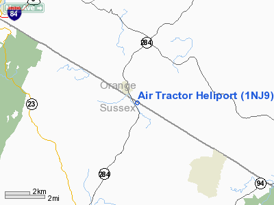
| From nearest city: | 1 nautical miles NW of Sussex, NJ |
| Location: | Sussex County, NJ |
| Magnetic Variation: | 13W (1985) |
Owner & Manager
| Ownership: | Privately owned |
| Owner: | Air Tractor |
| Address: | Po Box 604
Sussex, NJ 07461 |
| Phone number: | 201-875-5458 |
| Manager: | Donald Robertson |
| Address: | Po Box 604
Sussex, NJ 07461 |
| Phone number: | 201-875-5458 |
Airport Operations and Facilities
| Airport Use: | Private |
| Wind indicator: | Yes |
| Segmented Circle: | Yes |
| Control Tower: | No |
| Sectional chart: | New York |
| Region: | AEA - Eastern |
| Boundary ARTCC: | ZNY - New York |
| Tie-in FSS: | MIV - Millville |
| FSS Toll Free: | 1-800-WX-BRIEF |
Runway Information
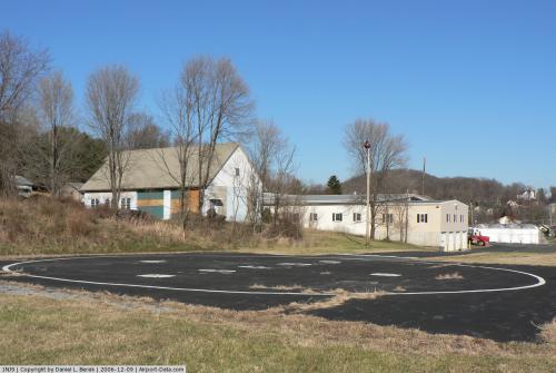
Helipad H1
| Dimension: | 30 x 30 ft / 9.1 x 9.1 m
HELIPAD TRIANGLE IN SHAPE WITH EACH SIDE 30 FT IN LENGTH. |
| Surface: | TURF, |
| |
Runway H1 |
Runway |
| Traffic Pattern: | Left | Left |
|
Radio Navigation Aids
| ID |
Type |
Name |
Ch |
Freq |
Var |
Dist |
| SKU | FAN MARKER | Stanwyck | | | 12W | 26.9 nm |
| EWR | FAN MARKER | Maryann | | | 11W | 39.0 nm |
| SW | NDB | Neely | | 335.00 | 14W | 18.7 nm |
| SKU | NDB | Stanwyck | | 261.00 | 12W | 26.9 nm |
| PNJ | NDB | Paterson | | 347.00 | 12W | 27.5 nm |
| PO | NDB | Meier | | 403.00 | 12W | 31.4 nm |
| MS | NDB | Monga | | 359.00 | 12W | 31.8 nm |
| CAT | NDB | Chatham | | 254.00 | 11W | 33.5 nm |
| HUO | VOR/DME | Huguenot | 108X | 116.10 | 11W | 7.4 nm |
| STW | VOR/DME | Stillwater | 033X | 109.60 | 11W | 22.9 nm |
| BWZ | VOR/DME | Broadway | 089X | 114.20 | 11W | 32.1 nm |
| TEB | VOR/DME | Teterboro | 021X | 108.40 | 11W | 34.6 nm |
| IGN | VOR/DME | Kingston | 123X | 117.60 | 12W | 39.8 nm |
| LGA | VOR/DME | La Guardia | 078X | 113.10 | 12W | 43.0 nm |
| SBJ | VOR/DME | Solberg | 076X | 112.90 | 10W | 43.4 nm |
| CMK | VOR/DME | Carmel | 113X | 116.60 | 12W | 43.8 nm |
| SAX | VORTAC | Sparta | 104X | 115.70 | 11W | 13.5 nm |
| LHY | VORTAC | Lake Henry | 045X | 110.80 | 10W | 43.5 nm |
Images and information placed above are from
http://www.airport-data.com/airport/1NJ9/
We thank them for the data!
| General Info
|
| Country |
United States
|
| State |
NEW JERSEY
|
| FAA ID |
1NJ9
|
| Latitude |
41-17-28.340N
|
| Longitude |
074-33-03.576W
|
| Elevation |
540 feet
|
| Near City |
SUSSEX
|
We don't guarantee the information is fresh and accurate. The data may
be wrong or outdated.
For more up-to-date information please refer to other sources.
|
|


