 |
|
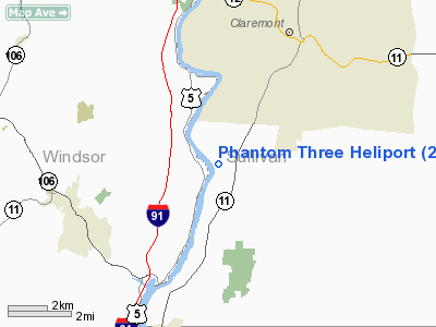
Location & QuickFacts
| FAA Information Effective: | 2008-09-25 |
| Airport Identifier: | 25NH |
| Airport Status: | Operational |
| Longitude/Latitude: | 072-23-23.0000W/43-19-01.6000N
-72.389722/43.317111 (Estimated) |
| Elevation: | 410 ft / 124.97 m (Estimated) |
| Land: | 0 acres |
| From nearest city: | 5 nautical miles SW of Charlestown, NH |
| Location: | Sullivan County, NH |
| Magnetic Variation: | () |
Owner & Manager
| Ownership: | Privately owned |
| Owner: | Merriam-graves Corp. |
| Address: | 806 River Rd
Charlestown, NH 03603 |
| Phone number: | 603-542-8768 |
| Manager: | Henry K. Wakeman Iii |
| Address: | 806 River Rd
Charlestown, NH 03603 |
| Phone number: | 603-542-8768 |
Airport Operations and Facilities
| Airport Use: | Private |
| Wind indicator: | Yes |
| Control Tower: | No |
| Sectional chart: | New York |
| Region: | ANE - New England |
| Boundary ARTCC: | ZBW - Boston |
| Tie-in FSS: | BGR - Bangor |
| FSS Toll Free: | 1-800-WX-BRIEF |
Runway Information
Helipad H1
| Dimension: | 40 x 40 ft / 12.2 x 12.2 m |
| Surface: | TURF, |
| |
Runway H1 |
Runway |
| Traffic Pattern: | Left | Left |
|
Radio Navigation Aids
| ID |
Type |
Name |
Ch |
Freq |
Var |
Dist |
| R | FAN MARKER | Chitt | | | 14W | 31.9 nm |
| LCI | FAN MARKER | Laconia | | | | 44.0 nm |
| CNH | NDB | Claremont | | 233.00 | 16W | 3.2 nm |
| SXD | NDB | Springfield | | 265.00 | 15W | 9.1 nm |
| IVV | NDB | White River | | 379.00 | 16W | 15.0 nm |
| LAH | NDB | Hanover | | 276.00 | 15W | 24.9 nm |
| VWD | NDB | Mount Snow | | 224.00 | 15W | 31.3 nm |
| DYO | NDB | Smuto | | 221.00 | 15W | 34.0 nm |
| LC | NDB | Blnap | | 328.00 | 16W | 39.5 nm |
| CO | NDB | Epsom | | 216.00 | 16W | 42.8 nm |
| ORE | NDB | Orange | | 205.00 | 15W | 45.2 nm |
| AS | NDB | Chern | | 359.00 | 16W | 45.6 nm |
| LEB | VOR/DME | Lebanon | 084X | 113.70 | 15W | 23.0 nm |
| RUT | VOR/DME | Rutland | 47X | 111.00 | 15W | 27.5 nm |
| CAM | VOR/DME | Cambridge | 097X | 115.00 | 14W | 46.1 nm |
| MPV | VOR/DME | Montpelier | 045X | 110.80 | 16W | 46.3 nm |
| EEN | VORTAC | Keene | 031X | 109.40 | 14W | 31.7 nm |
| CON | VORTAC | Concord | 076X | 112.90 | 15W | 36.1 nm |
| GDM | VORTAC | Gardner | 043X | 110.60 | 14W | 48.6 nm |
Remarks
- DO NOT CONDUCT DEPARTURES TO THE NORTH & NORTHEAST DUE TO TALL TREES.
- PRVDD PR USE; PRIMARY APCH/DEP 025 DEG & 205 DEG;VFT OPNS; AREA IS MKD; & WIND INDICATOR IS MAINTAINED.
Images and information placed above are from
http://www.airport-data.com/airport/25NH/
We thank them for the data!
|
|


